Stonehenge may be the most famous, but fascinating prehistoric monuments and sites can be found across England.
Beyond Stonehenge: Where To Find Lesser-Known Prehistoric Sites in England
Stonehenge may be the most famous, but fascinating prehistoric monuments and sites can be found across England.
Beyond Stonehenge: Where To Find Lesser-Known Prehistoric Sites in England
The original article from which this post comes from was first published in June 2014 for The Celtic Guide, a free to download magazine.
Water – it is life giving and for some life changing. It shows us a reflection of ourselves and without it we and all around us would cease to exist. It is essential to our being. Many cultures, past and present, have recognised this simple fact. For the ancient Egyptians it was from water that all creation began, in ancient Mesopotamia water was regarded as a symbol of absolute wisdom. In many situations water is given anthropomorphic qualities which are almost always female. Interpretations of the meaning behind the names for the Rivers Dee and Don in Scotland range from ‘the goddess’ to ‘the mother’. Identification with the female is common thread across the world’s cultures.
Today the most sacred river to Hindus is the river Ganges; it is worshipped as the goddess Ganga who descended from heaven to earth. To bathe in the waters of the Ganges is to wash away your sins; her waters are seen as both pure and purifying. It is also believed the Ganges flows in heaven, earth and the netherworld and is regarded as a crossing point of all beings, the living and the dead. Thus it is very desirable to have the ashes of a loved one scattered on the Ganges. This belief in the sanctity of the river, and all rivers, began early in Indian culture and has continued uninterrupted for several thousand years.
Heading far to the west and much closer to home, we arrive in Britain and ask ourselves was water important to our ancestors? The answer would be a definitive “Yes”. In fact, the importance of watery places in Britain’s past is a given for archaeologists and other like-minded individuals. There have over the years been numerous outstanding excavations and archaeological finds to back this up.
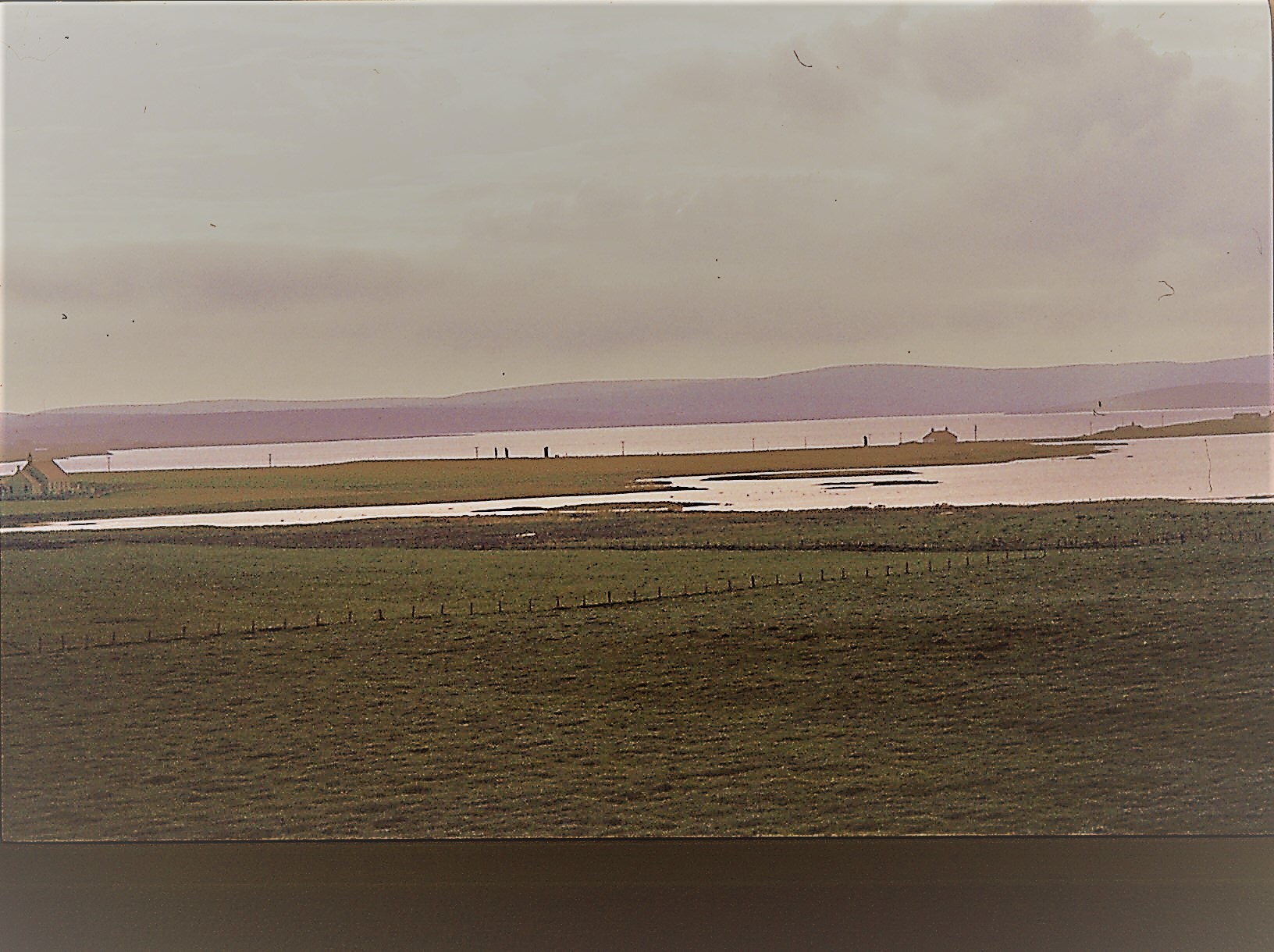
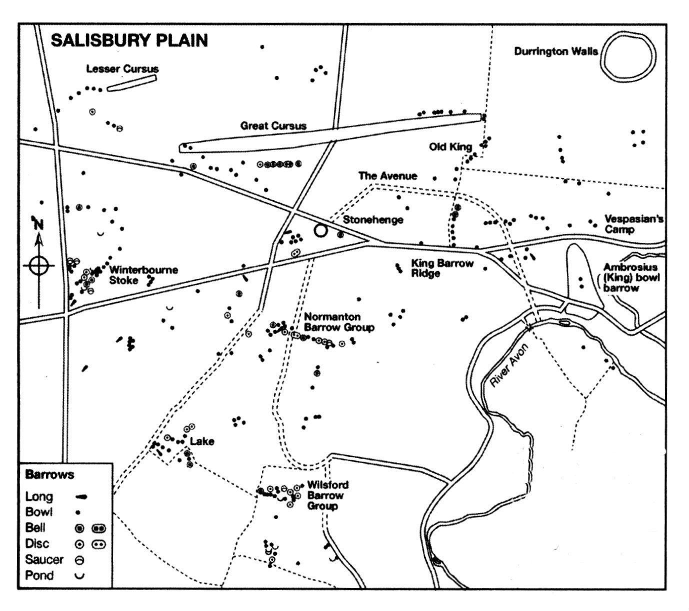
The relationship people had with water in both Britain and Irelands past can be seen as far back as the Neolithic. During this time people were beginning to make their mark on the landscape constructing sizable and (fairly) permanent monuments such as Stonehenge, Ness of Brodgar and New Grange. Such sites are usually part of a wider ‘sacred’ landscape, often surrounded by many other monuments of varying type and size but what is of interest to us here is their relationship to water. Thus the Stonehenge sacred landscape is bounded by the River Avon in the south and east, whilst New Grange and associated sites are nestled in what is known as the Bend in the Boyne (the river Boyne). The Ness of Brodgar, as well as a large number of other sites, in Orkney is situated on thin strip of land with the saltwater Loch of Stenness on one side and the freshwater Loch of Harry on the other. In this landscape there is very little to differentiate the water from the sky.
The reasons for the placement of such sites near rivers may never be fully understood but it is possible to say the symbolism is inherent but as Francis Pryor says in his book Britain BC (2003) “…it would be very easy to oversimplify our reading of that complex, layered symbolism that contained within it the shared histories of the people who created, nourished and guarded it. To say, for example, that water symbolised a soul’s journey to the next world is banal. It may have done – indeed it probably did – but it also marked boundaries in this world, and provided corridors along which people could move without crossing too many tribal frontiers.”
The Neolithic would have been a very alien world to our modern minds and trying to assess the symbolism of a natural phenomenon is fraught with numerous pitfalls. Regardless, it is important to take heed the role of waterways in Neolithic life. The lifestyle of the Neolithic would have been reasonably mobile, with people moving around the landscape following the seasons.
“Where people moved around the land, pathways between places would be emphasised, and monuments placed beside them. Given the scale of many Neolithic monuments, they may also have been placed at locales where groups were in closer proximity at certain times of the year.” (Barnatt J. ‘Monuments in the Landscape: Thoughts from the Peak’ Prehistoric Ritual and Religion. Eds. A Gibson and D. Simpson).
After the Neolithic we have the Bronze Age, a period heralded, as the name would suggest, by the appearance of metal objects (bronze, copper and gold) within the archaeological record. We also see an increasing (albeit gradual) degree of sedentary behaviour, with family type groups concentrating their activities at permanently laid out farms and fields. Many (but not all) of the monuments of the Bronze Age began to reflect this more localised behaviour with smaller monuments being built by these groups for their own use. The monuments are now found in all manner of landscapes and it would it appear that water is no longer of importance. However, excavations at sites such as Flag Fen, Lincolnshire and the finds from Duddington Loch, Edinburgh or the Rivers Thames, Trent or Witham to name a few all suggest that watery places were still of great ritual importance.
In the early days of discovery such finds were often attributed to accidental loss however the excavations at Flag Fen have seem to indicate the majority of the items deposited were done intentionally and with no desire to retrieve them. In 1984 Francis Pryor began excavating a post alignment at Flag Fen. It was 10m wide and consisted of five roughly parallel rows of posts. During the 1989 dig season the excavators began to find some unusual artefacts, some three hundred and twenty metal objects, mostly made of bronze and dating from the Bronze Age. Swords, daggers, jewellery, axe-heads, spearheads and pieces of a metal shield were amongst the artefacts uncovered. Interestingly every object had been deliberately damaged before being placed carefully into the water. The deliberate destruction of artefacts prior to deposition at Flag Fen is not an isolated example.
At Duddington Loch a number of bronze objects were found, mostly weapons, and once more all had been broken or burnt prior to deposition. Still in Scotland, Late Bronze Age swords were found in the River Tay and three Late Bronze Age shields were recovered from a bog in Yetholm, Roxburgshire. Another feature of Bronze Age deposition is its longevity, At Flag Fen and the bog sites of Ireland such as Dowris, Co. Offaly; Mooghaun, Co. Clare and the Bog of Cullen in Co. Tipperary deposition did not occur as a single event rather it was the result of many individual events over a number of years. In the case of the Irish bogs over two hundred bronze artefacts have been found, deposited over a number of years.
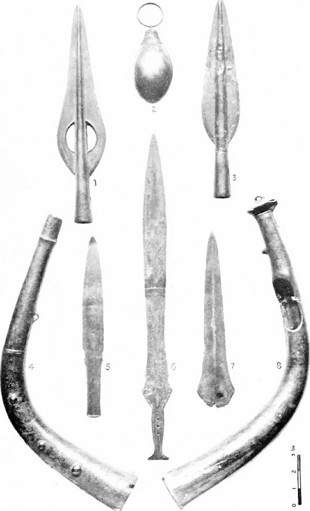
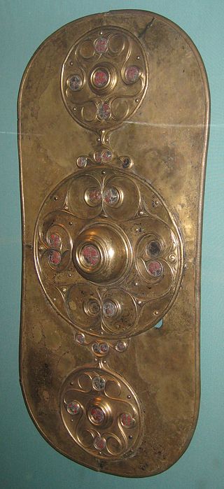
The tradition of deposition in watery places continues into the Iron Age. Still the weapons appear in rivers, for example, the Battersea Shield found in the River Thames, a horned helmet from under the Waterloo Bridge and the Witham Shield from the River Witham. An excavation at Fiskerton in Lincolnshire also discovered a causeway that led to Lindsey a significant patch of dry land which is essentially an island bounded by the rivers Humber and Trent to the north and east and the Witham and fens to the south. Here the archaeologists found swords, spearheads and other artefacts deposited into the wet ground. Interestingly it has been suggested that the deposits coincided with periods when the causeway was being rebuilt around the time of lunar eclipses.
Similar to the Bronze Age, the bogs and lakes of the west seem to be the place of choice for ritual deposition. The most well known is Llyn Cerrig Bach (originally a lake) in Anglesey. From here some one hundred and fifty objects were recovered. The finds from Lylyn Cerrig Bach are regarded as the most important collection of La Tene style metalwork in Britain to be found. The artefacts found included two slave chains, swords, spearheads, a bronze trumpet, cauldrons, iron bars, blacksmith tools and animal bones. Once more all had been deliberately broken and deposited over a long period of time, approximately from 300BC to 100AD. In fact there may have been a double whammy of sacredness here, as it has been suggested that islands represented sacred spaces because they were bounded by water on all sides.
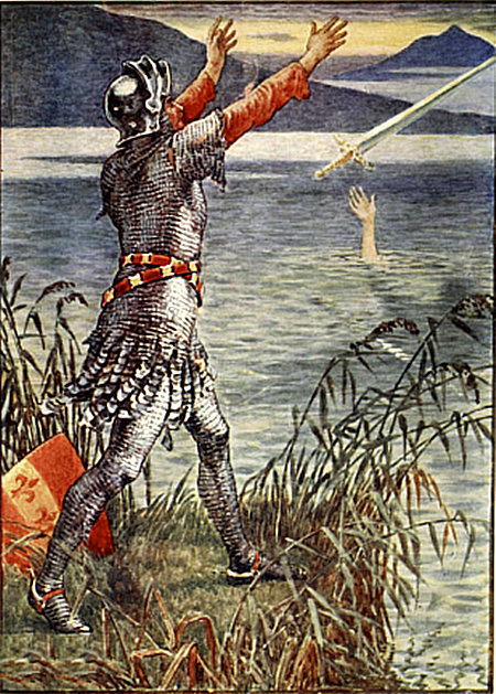
This connection between water and the deposition of weapons is embodied by the later legends of King Arthur. In Malory’s version King Arthur instructs Sir Bedivere “…take thou Excalibur, my good sword, and go with it to yonder waterside, and when thou comest there I charge thee throw my sword in that water”. For some this could be regarded as a cultural memory, a continuation of a ritual performed by our ancestors for many generations.
But it is not only lakes and rivers that were important there were also the peat bogs. Finds from peat bogs are of a relatively common occurrence given the use of peat for fuel. Of course the most famous of all bog deposits are the human bodies. Bog bodies are well known in several European contexts for example, Tollund Man found in a Danish bog. However, there are also examples from Germany, Holland, Norway and Sweden. The tradition goes right back to the Mesolithic and culminates in the Iron Age and early Roman period.
One of the most dramatic discoveries in Britain was that of ‘Lindow Man’ found in a peat bog at Lindow Moss in Cheshire. The remains were of a young male (mid 20s) who had been violently killed from a blow to his head, strangled and a cut to his throat. A detailed examination of the remains suggests he was of a high status. His teeth were healthy, his nails manicured and his beard and moustache neatly trimmed, in addition there were none of the usual signs on the bones that he had ever done any heavy manual labour. Radiocarbon dating has his death and deposition at somewhere in the mid first century AD.
Many reasons for such a grisly deposition have been put forth, from murder and violent robbery to human sacrifice. Sacrifice in the Iron Age was well known and took many forms either as the sacrifice of an object, an animal or a person.
“The Celts did not love their deities; they made contracts with them as they did in their own society. By making offerings into pits, wells, springs, peat bogs and all watery places, no doubt with the solemn attendant ritual, the druids were in fact ‘binding’ the gods into making reciprocal gifts to mankind…” (A Ross ‘Ritual and Druids’ in The Celtic World ed M Green).
It would seem that the greater the ‘ask’ the greater the sacrifice. The Lindow man was deposited at a time of turmoil in Britain, northern England was not properly subjugated by the Romans until well into the first century AD, perhaps he represents a last ditch attempt by the Druids asking for the Gods intervention? Perhaps his grisly death is a reflection of ‘destroying’ an object before it is deposited into its watery grave? Throughout Britan and Ireland there have been almost two hundred documented cases of bodies found in bogs. Not all are dated to the Iron Age and not all can be given a ritual explanation.
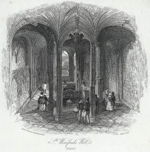
Any discussion on the sacredness of watery places needs to include springs and wells. Unfortunately, the majority of springs have been tampered with, cleared out and utilised to such a degree in our history the evidence is very sparse indeed. Some prehistoric sites are associated with springs through proximity such as Swallowhead springs which is near the Neolithic monuments of Silbury Hill and West Kennet long barrow. However, the best preserved piece of evidence comes from the town of Bath. Here we have the very famous Roman baths based around the springs dedicated to the goddess Sulis Minerva. The impressive complex of baths and temples built by the Romans began some fifteen years after the Boudiccan rebellion. It does seem this was an attempt to do honour to a local deity – Sulis – by aligning it with one of the more significant Roman deities – Minerva. It is well recorded by the Romans the importance of this site to the local people. Thousands of coins of both Roman and Celtic type have been found in or near the hot springs in addition to many curse tablets of a Roman date.
This tradition of offerings to a spring or well continues into the modern day. Throwing a coin into a well to make a wish is a common practice as is the tradition of well dressing. Every summer throughout the counties of Britain wells are cleaned up and made pretty. The longevity of this practice is well attested, in 960 a canon was issued that expressly forbade the ‘worship of fountains’ and yet it could not be suppressed, eventually the church turned these pagan sites into Christian holy wells. In some cases the well or spring has a special tree nearby, a Clootie tree. The clootie is a piece of cloth that has been dipped in the spring’s water and then tied to the tree, after which a supplication is given to the saint or deity of the spring. Many of these springs are associated with healing, in some cases the clootie represents the ailment and it is believed that once it has perished then so will the ailment.


Furthermore it is not unusual for a church to be built near a sacred spring or well such as St Oswalds in Cumbria or at Golant in Cornwall. Some have even embraced the sacred well as is the case for St Winefride’s well in Holywell, Wales. In fact the overall sanctity continues well into the Christian era, monasteries can be found on islands (St Michael’s Mount or Lindisfarne) and many other Christian religious houses are situated close to rivers.
This article merely scratches the surface but from reading and research it soon becomes apparent that water in all its forms has played a major role in the history and prehistory of our world. It has defined where we live and it has defined how we live, indeed if we live at all. That our ancestors’ revered water should be of no surprise to us and yet often it is.
“Water is life’s mater and matrix, mother and medium. There is no life without water.” Albert Szent-Gyorgi
“Nothing is weaker than water, yet for overcoming what is hard and strong, nothing surpasses it.” Lao Tzu
A recent interesting blog from the British Museum which talks about the Thames – “Secrets of the Thames”.
Stonehenge – a name that evokes a great many emotions in a great many people. For some it is a place of pilgrimage, a place to connect with the ancestors and for others it is seen as a tourist trap or something to tick off the bucket list. For centuries it has captured our imagination; never has a heritage site been so controversial – something which continues to this day. In this post it is not my intention to give a full on thesis about Stonehenge, there are plenty of books/websites who do this already. Instead it is simply an overview of what is currently understood about the site, its surrounding landscape and my own personal thoughts.
Stonehenge is situated on the Salisbury Plains, to the south is the busy A303, a main road between the south-west and London, and for many years the equally busy A344 ran alongside the site. This latter road was removed sometime ago to improve the visitors experience. Today there are ongoing discussions regarding the upgrading of the A303 and a proposed tunnel. It is a highly emotive subject, on one hand I understand the need to improve the road situation (ask anyone who is stuck in a traffic jam on the A303) but as an archaeologist I am also aware of the sensitive nature of the surrounding heritage landscape (and yes I am on the fence). Mike Pitts in his recent post discusses the pros and cons for those of you who are interested.
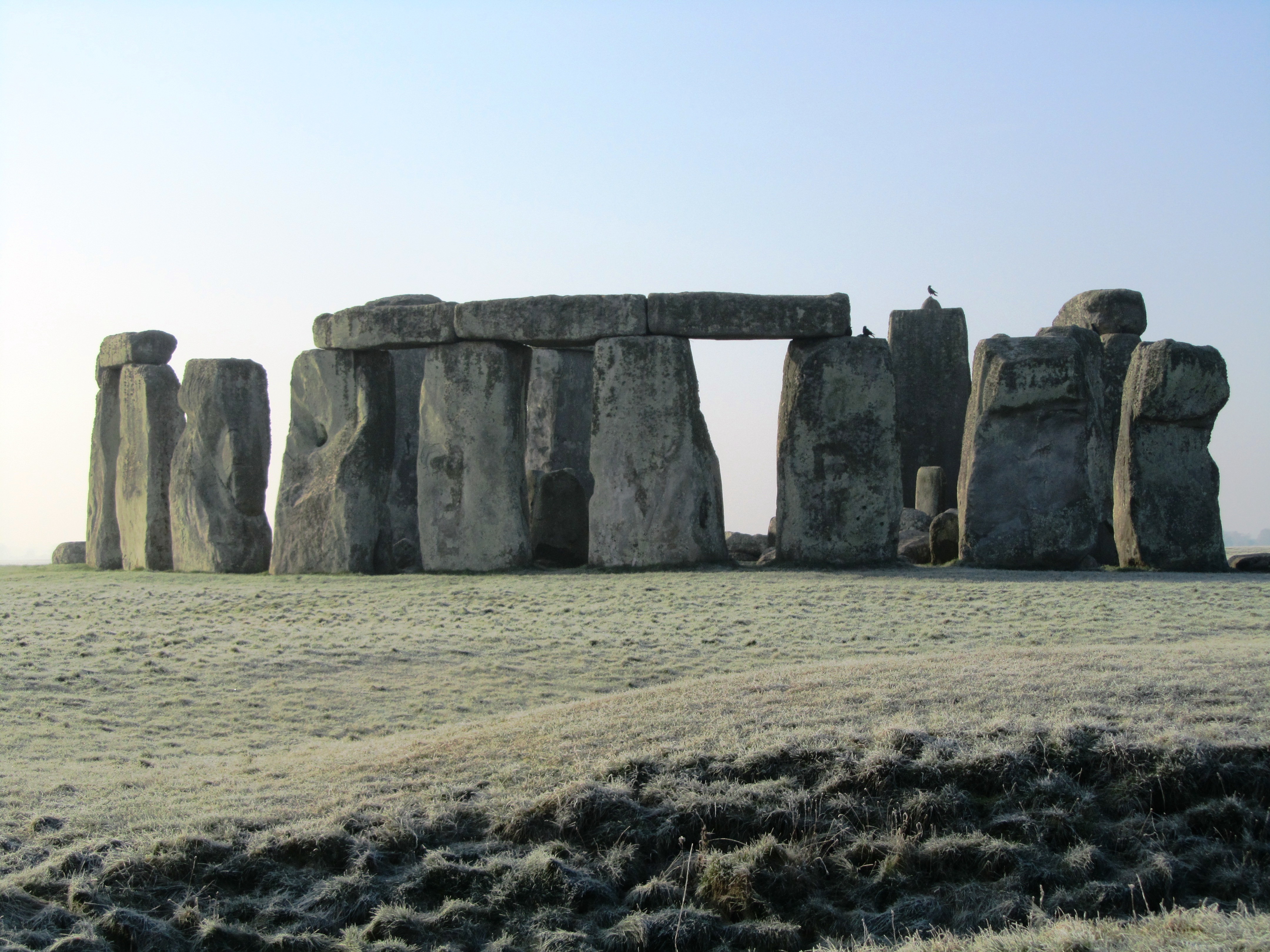
For the visitor today the focus is on the large stone circle with its trilithons, they marvel at how it could have been built by ‘primitive man’ often leading to suggestions of alien intervention and lost technologies. But such thoughts only serve to belittle our ancestors and our past. Others may ask why did our ancestors build Stonehenge? Often the answers are unimaginative and simple – sun-worship; display of power; ancient computer; druid temple – once more when we look only for one answer to a what is obviously a complicated site of great longevity we belittle their achievements. Instead if Stonehenge was understood in terms of the wider landscape and as a site whose history spanned several millenia we might come to some small understanding of how and why.
In today’s world of instant gratification where everything has a beginning and an end, it is hard to imagine beginning a project knowing you might not see it finished but this was a reality for the builders of Stonehenge. It has lead some to suggest that it was not the end product which was important but the doing, the act of building which was in fact the purpose. Suggesting a cyclical thought pattern which can be seen in other aspects of prehistoric life – round houses, stone circles, round barrows. in addition, time itself was most likely viewed in cycles, the phases of the moon and the movement of the seasons are all cyclical events which would have been of great importance to prehistoric people trying to make sense of their world.
“So was Stonehenge ever ‘finished’? The answer to that has to be no, because completion was never the intention of the people who created it.” (Pryor F. 2016 ‘Stonehenge: The Story of a Sacred Landscape).
It is well known that Stonehenge itself had many incarnations, perhaps meaning new and different things with each alteration or rebuild. To understand Stonehenge it is important to consider it in the wider context of the surrounding landscape (there are literally hundreds of prehistoric monuments around it) in all the different phases.
The Mesolithic Story
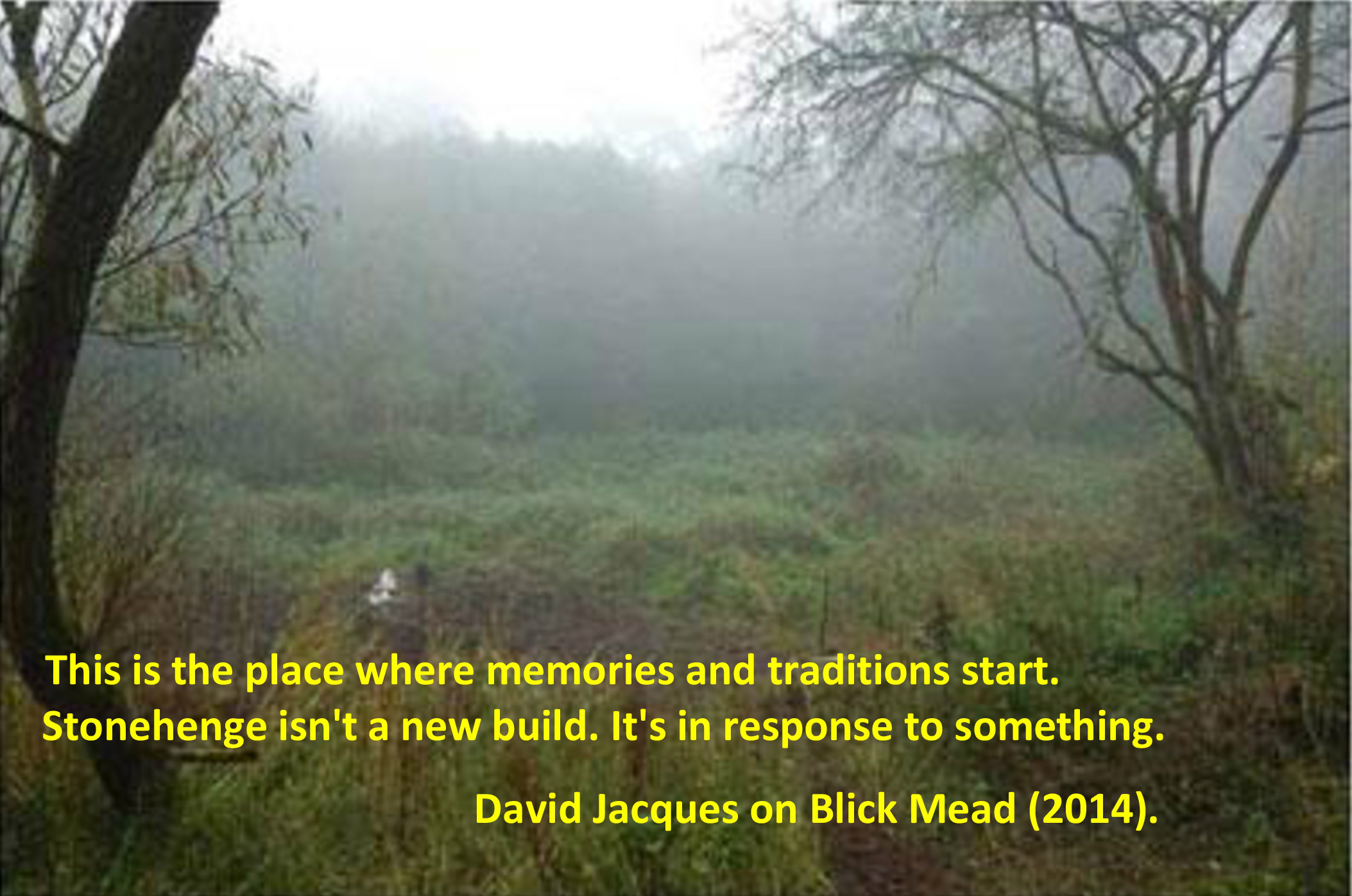
The story of the Stonehenge landscape begins back in the Mesolithic, ongoing recent excavations at Blickmead are providing archaeologists with tantalising clues as to why this area was important to our ancestors. The site is situated near a spring by the River Avon, excavations began in 2005 and almost immediately were fruitful. Basically, the deposits consisted of an array of Mesolithic settlement debris, mostly flint fragments (tens of thousands) but also a great number of animal bones. Interestingly, the site also yielded the largest collection of auroch bones ever found on a Mesolithic site in Britain so far. Other animals which were hunted and consumed included red deer, wild boar and salmon – this has led archaeologists to suggest that feasting was a common occurence around the spring. The spring itself is quite unusual as it has the tendency to stain flints and other materials a bright magenta pink – the importance of springs in later prehistory is well attested to.
In 1966 row of four large pit like features were found during upgrades to the old carpark close by Stonehenge. When excavated one was found to be a the root-hole of a tree and the other three were holes dugs to hold large poles. Examination of the material from these features gave a date range from between 8500 and 7000BC. The posts would have been approximately 75cm in diameter and were from pine trees. Later in 1988 another post-hole was discovered south and east of the original pits but it was contemporary.
So here we have a landscape already well populated by hunter-gatherer communities who revered certain natural features long before Stonehenge makes an appearance. A landscape which had meaning to the people who inhabit it; who had traditions and memories of place.
At around 3500BC (Neolithic) with the arrival of farming these communities and their traditions had evolved and more permenant features began to make an appearance on the landscape. Long barrows such as those at East and West Kennet or Winterbourne Stoke were the first to appear and by 3400BC the Stonehenge Cursus and Lesser Cursus was under construction.
3000BC – The first official phase of construction
In many parts of Britian at this time a new type of monument was being constructed, these were earthwork enclosures which are referred to as henges. They consist of irregular cut ditches encircling a defined area with corresponding banks. Stonehenge’s earliest phase was one such earthwork. Here there were two entrances one faced north-east and the other faced south. The north-easterly entrance remained in use for much of the sites lifetime and appears to be important to its function. The entrance is aligned along a line of natural gullies which face towards the midsummer sunrise in one direction and the midwinter sunset in the other.
These natural gullies would have been visible to the people of the Mesolithic and may have been why the large pine posts were erected where they were – the midsummer and midwinter solstices were just as important then as they were to the later prehistoric communities.
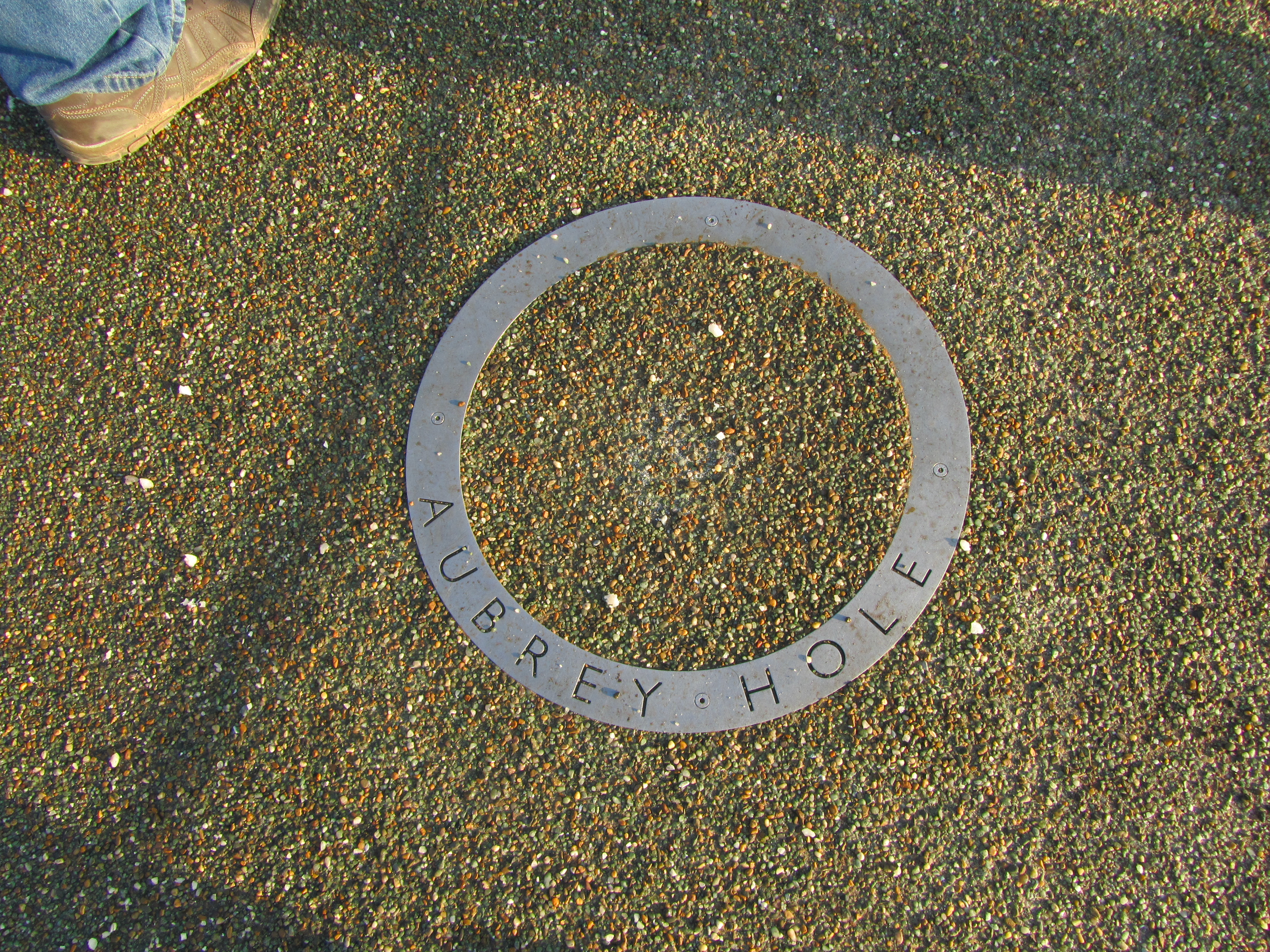
Inside the earthwork enclosure around the inner edge of the bank were fifty-six regularly spaced pits – these are now known as the Aubrey Holes. There is some discussion as to what they were or what they contained – small stone uprights or wooden posts? However, what is known is that eventually they did contain cremated human remains. Similar deposits have been found in the partly filled ditch and cut into the bank suggesting that at this stage in its history Stonehenge was used as a cemetary, among other things.
The Building of the Stone Monument
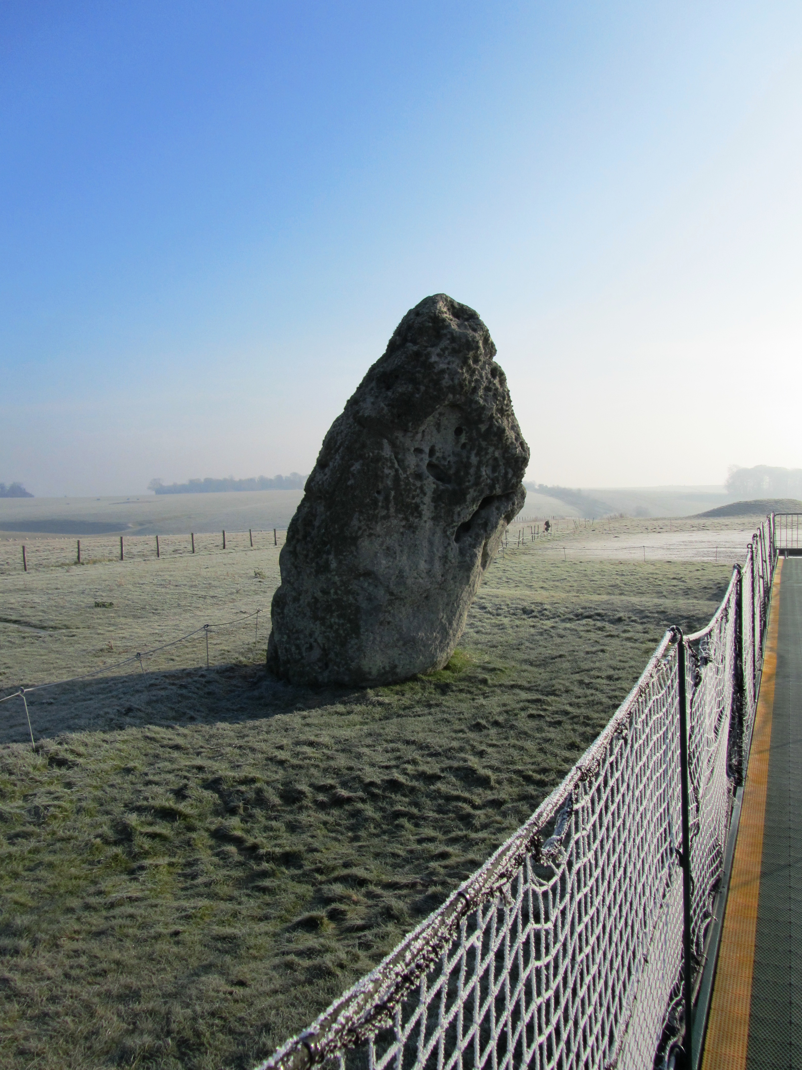
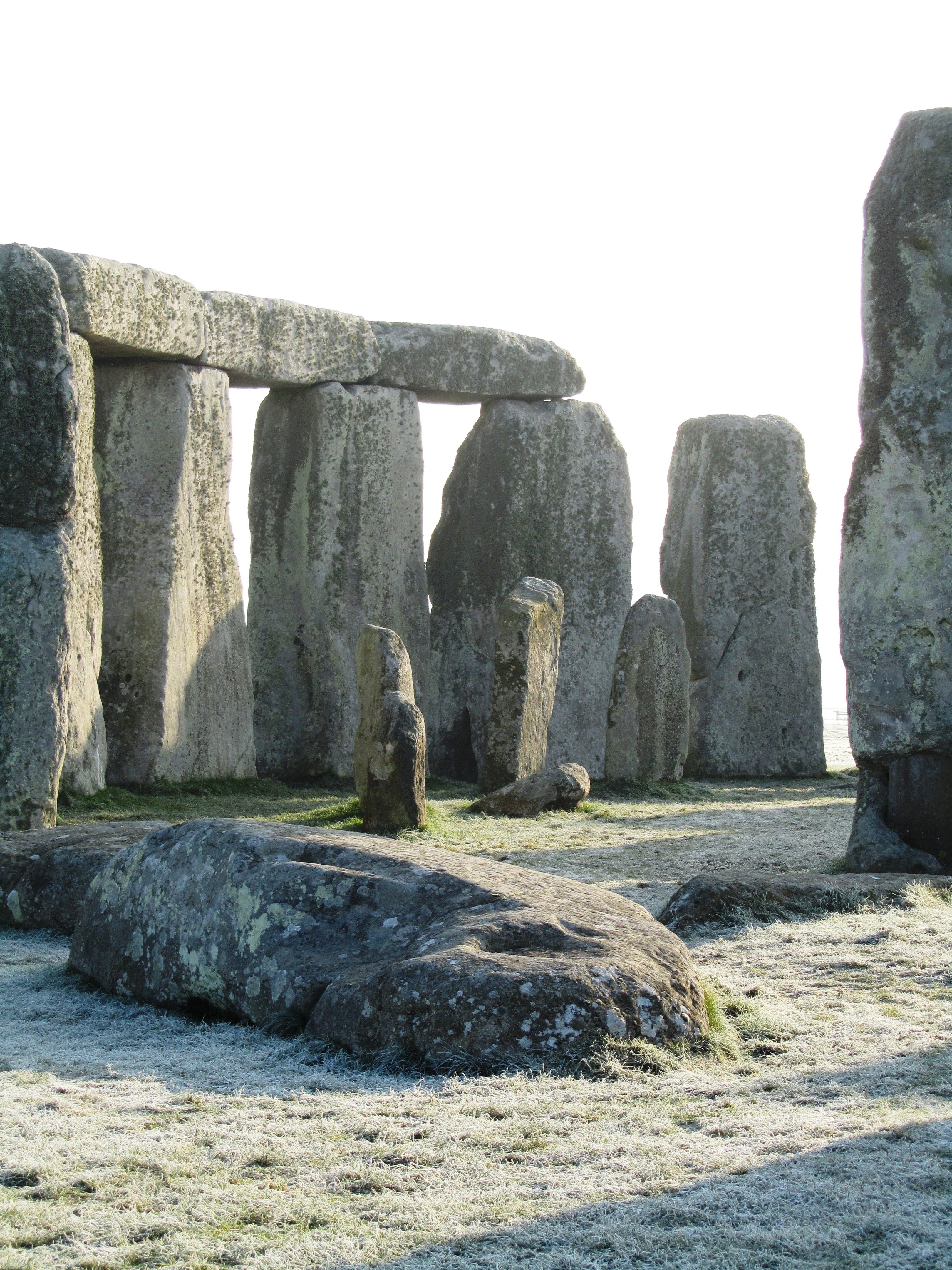
At around 2500BC Stonehenge began to resemble a site we are much more familiar with. It is at this time that the massive sarsen stones from the Marlborough Downs were moved to the site and erected. If that was not all at the same time the smaller but no less cumbersome, blue stones from the Preseli Mountains in Wales were transported and erected at Stonehenge. The Heel stone was moved to its current position and four smaller sarsen stones (the station stones) were erected inside the enclosure just inside the bank.
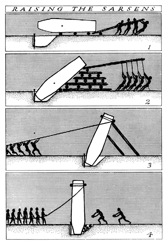
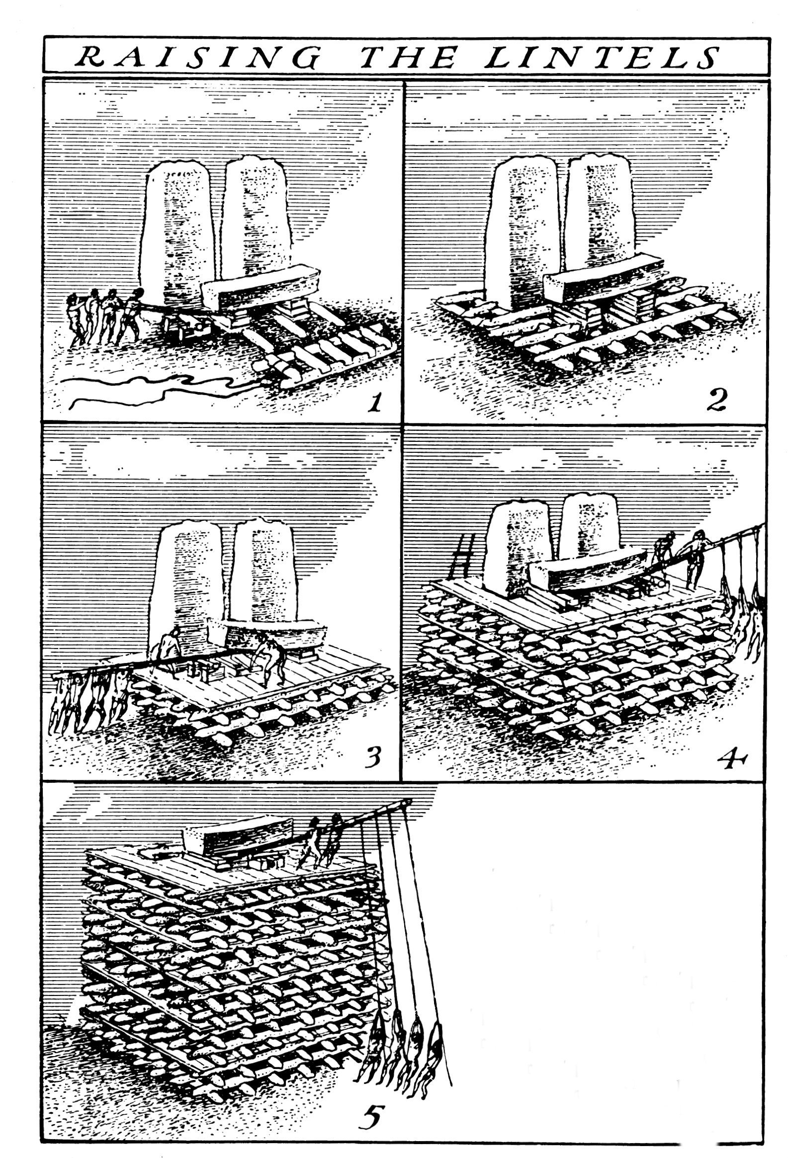
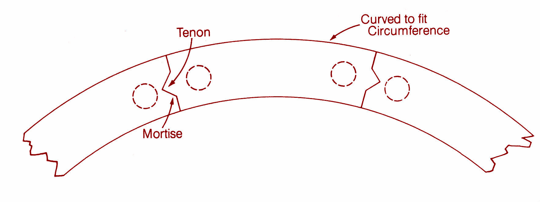
The first two diagrams above demonstrate one theory of how the trilithon stones were erected. The third diagram shows the sophistication of the construction, with each lintel fitting neatly into each other – borrowed from the Univeristy of Buckingham’s MOOC “Stonehenge”.
In a mere one hundred years it seems the two main structures of the trilithon horseshoe and the circle was completed. Interestingly it seems that greater care was taken in the shaping and construction of the stones visible from the north-east side and the main entrance. The bluestones were also erected at this time but not in the form we see today at Stonehenge. Excavation has shown us that there were two concentric arcs of stone holes, known as the Q and R holes were found on the north and east sides of the central area. It has been suggested that these were not representative of a complete circle as there is little to no evidence on the southern or western sides of corresponding holes.
2200BC – Consolidation and Alterations
From this time on Stonehenge underwent a series of minor alterations although the large sarsen stones remained in their positions although much later in the Bronze Age shallow carvings of axeheads and the occasional dagger were added. There are some 115 carvings and these have been dated stylistically to between 1750 and 1500BC.
The smaller bluestones however were rearranged and by 2200BC the incomplete circles were dismantled and repositioned to form a circle concentric to and just inside the circle of larger sarsen circle whilst a second oval of bluestones (spotted dolerite) was also formed within the trilithon setting. Later a number of stones were removed from the oval to form the horseshoe setting which is seen today.
At around the same time the ditch was recut and a small bank was constructed and the Avenue was constructed. This later feature follows the solstice alignment with ditches and banks for part of the way and then veers off to the east ending in a valley of the River Avon. Recent excavations at the place where the Avenue meets the River Avon have uncovered evidence for a previously unknown henge monument made up of bluestones. These were likely to have been removed to supplement the bluestones already at Stonehenge.
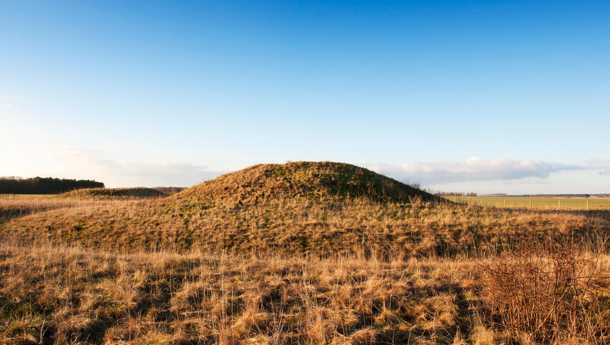
Surrounding the monument are significant numbers of round barrows dating from the Bronze Age, some of which contained rich burials with artefacts made of bronze, gold, jet and amber. Suggesting a society rather different from the one which was able to come together communally to construct Stonehenge and yet the place, the landscape and the site still had a powerful pull to these people – it is no different today…


Above are two of the many round barrows littering the landscape around Stonehenge.


The pictures above show a reconstruction of houses found during excavations at Durrington Walls which date to approximately the same time as when the main phase of construction at Stonehenge was underway. It is interesting to note the layout of the houses with the ‘dresser’ opposite the door and the beds to the right as you enter. This layout is reminiscent of house layouts at Skara Brae and later similar layouts are seen in Bronze Age roundhouses.
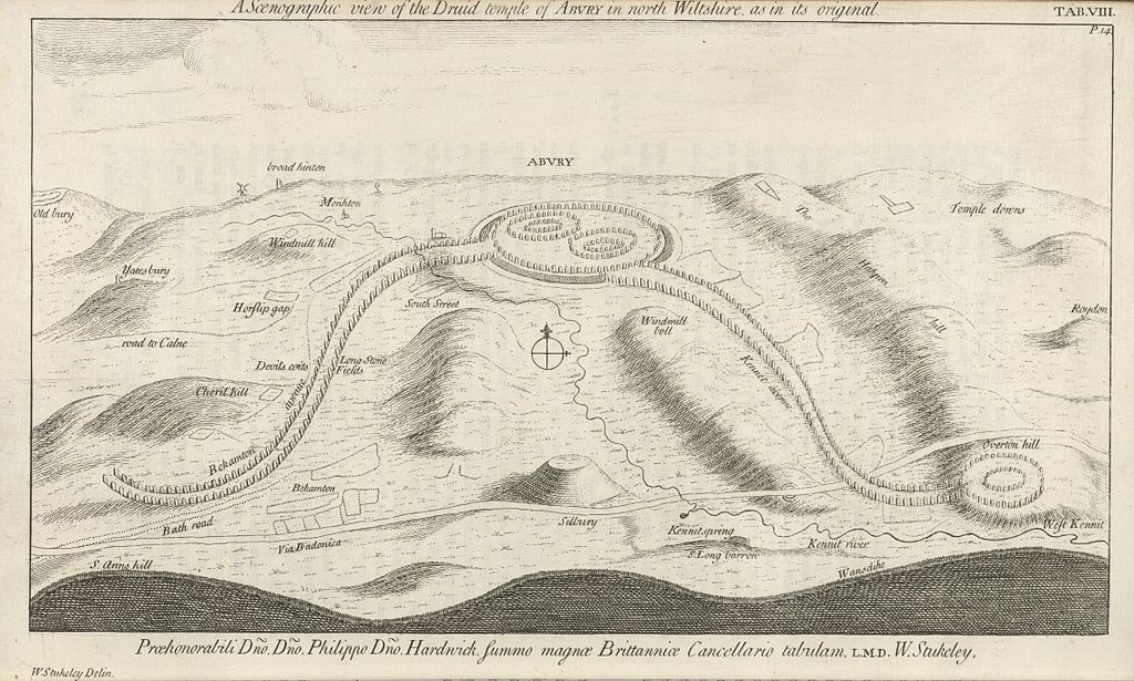
Stonehenge is a UNESCO World Heritage Site, it is one of the most popular tourist attractions in Britain; it evokes a variety of emotions; it is a British icon and yet so many people still only today see the stones. Yes they are impressive but there is so much more to their story than what you see. To really understand Stonehenge the curious need to look at the wider landscape and then look further again. Afterall, not too far away is the equally astounding landscape surrounding Avebury. What was the relationship between these two sacred landscapes? What can they tell us about the people who lived at the time? These landscapes were created by a people who viewed the world very differently to ourselves and carry a language, a dialogue that would have been obvious to those who lived in the Neolithic and even the Bronze Age. In our modern world where landscapes are viewed as places to use – either to make money or in terms of leisure pursuits – it is often hard for us to step back in time to view the landscape as living breathing entity without which we could not survive.
Stonehenge and its surrounding landscape undoubtedly meant many things to the people who occupied it (and probably those further afield too), the stones themselves were taken from the land and perhaps used to create a space where the natural world could be contained; where a semblance of control was maintained; where perhaps a balance was found between the natural world and the constructed world.
There are a great deal of books and websites which delve into the Stonehenge enigma in far greater detail. I have listed some of those below (browse Amazon for comprehensive lists). In particular I would like to recommend the free online course run by Buckingham University via Iversity (click here for more details).
Further Reading
Pryor F (2016) Stonehenge: The Story of a Sacred Landscape
Parker-Pearson M et al (2015) Stonehenge: Making Sense of Prehistoric Mystery
Parker Pearson M (2013) Stonehenge: Exploring the Greatest Stone Age Mystery
Bowden M et al (2015) The Stonehenge Landscape: Analysing the Stonehenge World Heritage Site.
If archaeology is your thing (and it’s certainly mine) then Cornwall is a great county to visit with a mulititude of sites to visit, especially if you want to get away from the crowds and sitting on the beach has lost its appeal. From the outset I should point out the following are my favourite sites/landscapes to visit (it was quite difficult to keep it to just ten and yes they are mostly prehistoric sites), others may have different views – the list is purely my own opinion. Feel free to comment on your favourites.
Okay so I have cheated a bit – here we have two very different sites but their proximity to each other I think allows for a bit of cheating…
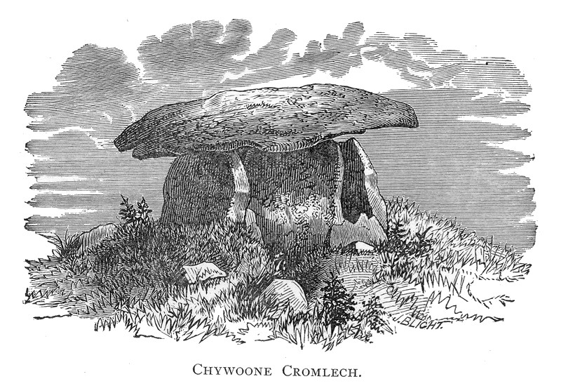
Firstly, Chun Quoit – quoits are neolithic monuments found throughout Cornwall (there are about a dozen known sites) consisting of upright granite slabs topped by a large capstone. They can also be called portal dolmens, chamber tombs or cromlechs. Some are in a better state of repair than others and Chun Quoit is perhaps one of the few which has been interferred with the least. Chun Quoit consists of four large uprights supporting a capstone which is estimated to weigh over 8 tonnes. It is also possible to see the remains of a circular stone cairn and associated kerbstones (the stone rubble at ground level) which would have originally surrounded the Quoit but not covering it leaving a the facade and the capstone visible.
Two hundred metres to the east of the quoit are the impressive remains of Chun Castle. Unlike many other Iron Age hillforts which utilise an earthen ditch and bank system Chun Castle is entirely stone built. It consists of two large concentric stone walls and is 85 metres in diameter. There is some evidence that the hillfort was built over an earlier enclosure represented by a shallow ditch and low bank on the southwest side. Inside the hillfort there is a stone lined well and escavations during the late 1920s found evidence for a later post Roman occupation of the hill fort. Iron Age occupation consisted of at least a dozen round houses which based on the pottery found date the site to the 3rd and 2nd centuries BC. Sitting high on the ridgeway known as the Tinners Way the site would have been visible from many miles around, from here it is possible to make out several other hillforts in the distance such as Caer Bran. Below the hillfort about 500metres to the north east is the site of Bosullow Trehyllys – a courtyard house settlement of the late Iron Age (see the earlier post on Chysauster and Carn Euny), it is unexcavated but appears to consist of at least three detached courtyard houses and a number of round houses.


I wanted to include a courtyard house settlement in the list and it was a choice between Carn Euny and Chysauster. In the end Chysauster won mainly because it is easier to get to but also because the visitor can get a good idea of size of this unique house type. However, I would recommend a visit to Carn Euny too – the fogou makes it well worth while. I have discussed both sites already in a previous post – Chysauster and Carn Euny – A Unique Settlement Type – so won’t say much more than that.


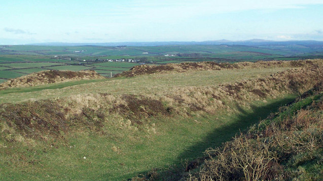
Treryn Dinas falls into the category of Iron Age cliff castle or promontory fort – one of many coastal headlands with Iron Age defences in the form of earthen or stone ramparts and external ditches usually across the neck of the headland. The term ‘cliff castle’ does not denote a particular function, some were large enough to have settlements within their walls, such as The Rumps and Trevelgue Head, others were much smaller and perhaps served as trading posts or lookouts. Treryn Dinas, however, appears to more than that – the visitor only need to look at the position and surroundings of this site to realise it is special.
Overlooking the beach at Porthcurno, the ramparts enclose a large rocky headland which contains the Logan Rock – a substantial boulder perched on the outcrop which in times past would rock in the wind and was only dislodged in 1824 by cocky young lieutenant and the crew of the HMS Nimble. The local people were rightfully upset at this and the lieutenant was charged to replace the rock at his own expense and with the help of the admiralty it was eventually returned to its original position, although it is said to no longer rock as easily as it had done once before.
According to folklore the earliest inhabitants of the headland were the giants who protected the neighbouring communities in return for cattle and other necessaries. Giants are a common feature in Cornish folkore and seem to be particularly associated with large outcrops of granite which feature in the landscape. From an archaeological point of view Treryn Dinas has four lines of defence with the last crossing the low neck of the headland. It consists of a deep ditch and a stone faced wall behind which are the foundations of two buildings either side of the presumed entrance. The general view is that this site is one of spiritual significance which may date many centuries earlier than the Iron Age. Finds of Bronze Age pottery have been found wedged in the crevices of the outcrop, the Logan Rock itself may have been seen as supernatural and there is the problem of that fourth line of defence. You will note in the photograph below that this line of defence is not particulary defensible as it easily looked down from the landward side, in addition the amount of useful land on the headland is extremely limited and the only thing the fourth rampart is ‘protecting’ are the rocks themselves.


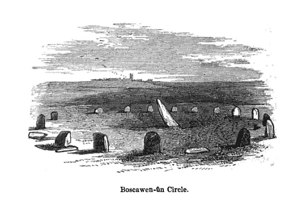
In the parish of St Buryan is the stone circle of Boscawen-Un, dating to the early Bronze Age and consisting of nineteen stones there are several interesting features of the site. The most obvious is the stone which is slightly south of center, it leans sharply towards the north east and at its base there are two very faint relief carvings of axe heads. A past student once suggested to me that the stone itself looked like a large stone axehead which had been struck into the ground. Minor excavations have further revealed that its leaning position was intentional and not the result of subsidence. The second interesting feature of this stone circle is the large block of quartz to the south west which is part of the circle. Our understanding of the role of quartz within prehistoric rituals is poorly understood but there is an increasing amount of evidence which points to its importance.
Boscawen-Un is one of several archaeological sites which feature in my novels – The Adventures of Sarah Tremayne.


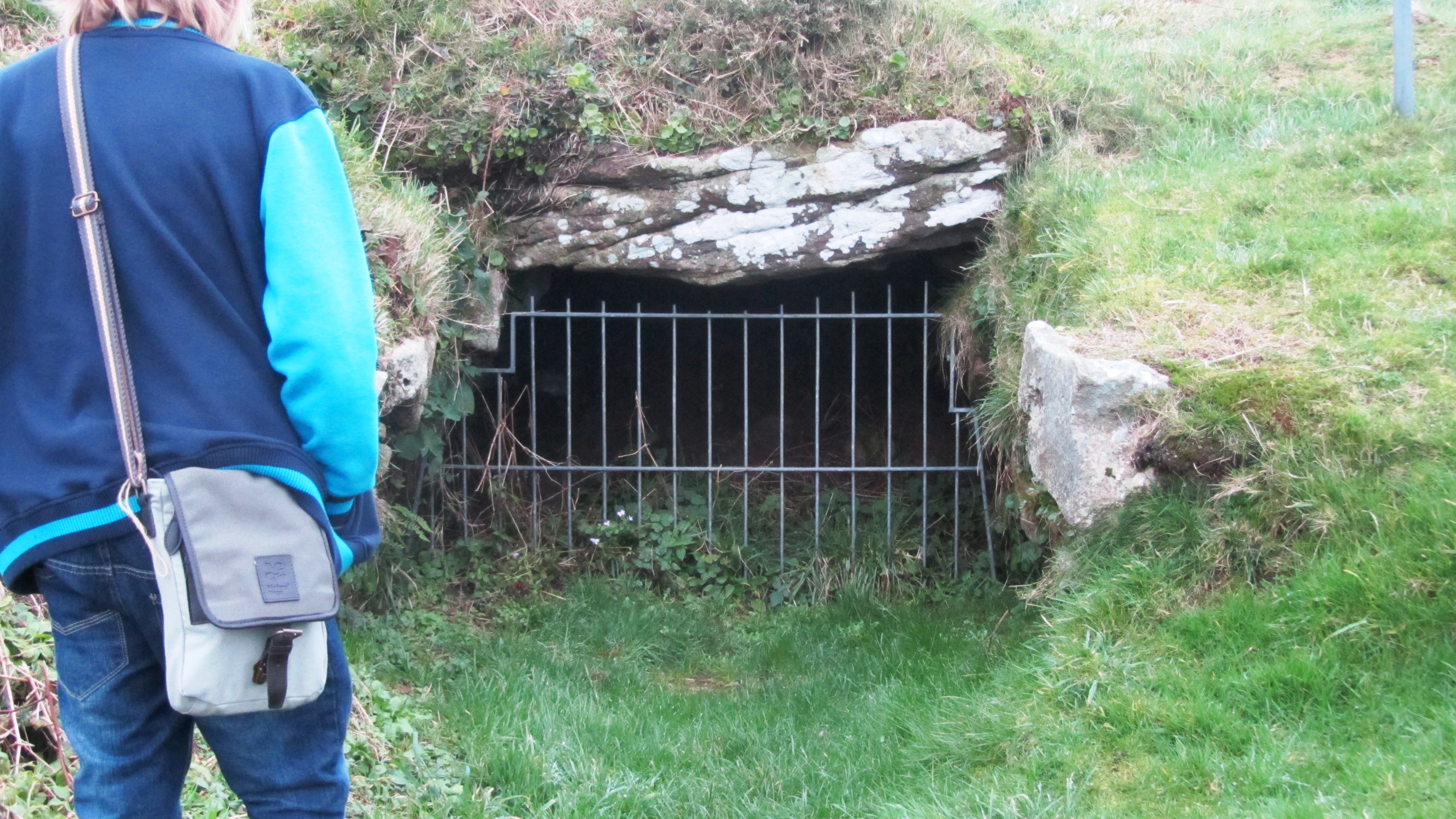
Okay, so now I really am cheating but the fact is any visit to Cornwall should definitly include a fogou and I couldn’t decide which I preferred – Carn Euny or Halligye are the easiest to get to and Halligye the largest (it can be found on the Trelowarren Estate, near Helston) however, Carn Euny does have a courtyard settlement, the nearby hillfort of Caer Bran and the fogou itself has a beehive shaped internal chamber. So you can see my dilemma…I have already written about fogous in an earlier blog so shall not rehash what we know and don’t know about these enigmatic structures.
Situated between Redruth and Camborne is long hill easily visible from the A30, it is a hill with a long history beginning as far back as the Neolithic. Today two features stand out the most, firstly the the tall monument on the central summit erected in 1836 in the memory of Francis Bassett of Tehidy and the second is the small medieval castle perched on an outcrop. The latter was most likely a hunting lodge belonging to the Bassetts, an ancient local family and was first recorded in the fifteenth century. The land surrounding the hill was prime tin mining country and the flanks of the hill are covered in shafts and pits.
Heading further back in time the astute visitor might notice the remains of eleven Iron Age roundhouses on the saddle between the east and central summits, these are part of a much larger settlement on the hilltop, set within a substantial hillfort of forty-six acres. The defences are made up of two ramparts enclosing the hill. However, the occupation of Carn Brea began much earlier in the Neolithic. Surounding the eastern and central summits are another two smaller enclosures, of these the eastern summit has been partially excavated. The date range showed that the ramparts had been built somewhere between 4000 and 3500BC, making it the oldest known fortified settlement in Britain. There were traces of wooden buildings and Neolithic pottery, in addition a large number of flint arrowheads (700+) were uncovered along with evidence for the destruction of the site suggesting the site had been under attack (Cornish Archaeology, 1981, 20).


So many visitors to Cornwall will invariably end up in Newquay without realising the long and fascinating history of this seaside town. Just north of St Columb Porth on the road to Watergate Bay is the impressive cliff castle of Trevegue Head. It is the most heavily defended of all the cliff castles with seven lines of defence. The first ditch and bank is not so obvious as the next six with largest bank being roughly four metres high. Erosion over the centuries has seen much of the land disappear and it is suggested this included the original entrance. Excavation in th 1930s demonstrated that Trevelgue was continously occupied from the thrid century BC until the fifth/sixth century AD. At least fourteen roundhouses were identified (it is still possible to see the house platforms with a keen eye). Given its position in the landscape, the sheer scale of the defences, some of the artefacts found (bronze horse harness and Roman coins) in addition to the significant amount of evidence for both bronze and iron smelting, it is fair to say Trevelgue Head was most likely a high status site, the home ground of someone of great import.
The importance of this headland and other similar to it along the coast is further attested to by the presence of the two bowl barrows dating to the Bronze Age – these were opened in late 1800s but nothing is known of their contents. Further along the coast is Trevelgue Downs where a further two barrows can be seen. In the eastern barrow a crouched adult skeleton was found within a stone cist with a stone battlexe close to hand. From personal experience I have walked this cliff castle many times and it was not uncommon to espy tiny Mesolithic flints protruding from the exposed edges of the paths. Further testament to the sites long history.


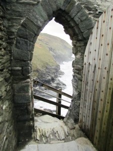
It had to be on the list – perhaps one of the most controversial of all sites in Cornwall from local resistance to English Heritage’s plans for the site to the myriad of myths and legends associated with Tintagel – no where captures the imagination more. Like several other sites on this list I have already waxed lyrical about Tintagel so will not bore the reader with much of the same (but do follow the link if you want to seperate fact from fiction).
An impressive example of an Iron Age hill fort found in mid Cornwall near St Columb Major. Measuring 260m across it would have been a formidable place in its heyday, the substantial ramparts are visible for many kilometres even today. There is some faint evidence for a much earlier enclosure on this hilltop possibly dating from the Neolithic or Bronze Age and the presence of two Bronze Age barrows within the hillfort is further testament to the importance of this place throughout prehistory. In the early 1960s a relatively small excavation was undertaken with the idea of prove the tradition of such places being re-used during the post-Roman phase and although they failed to do this a fine cobbled road was found.
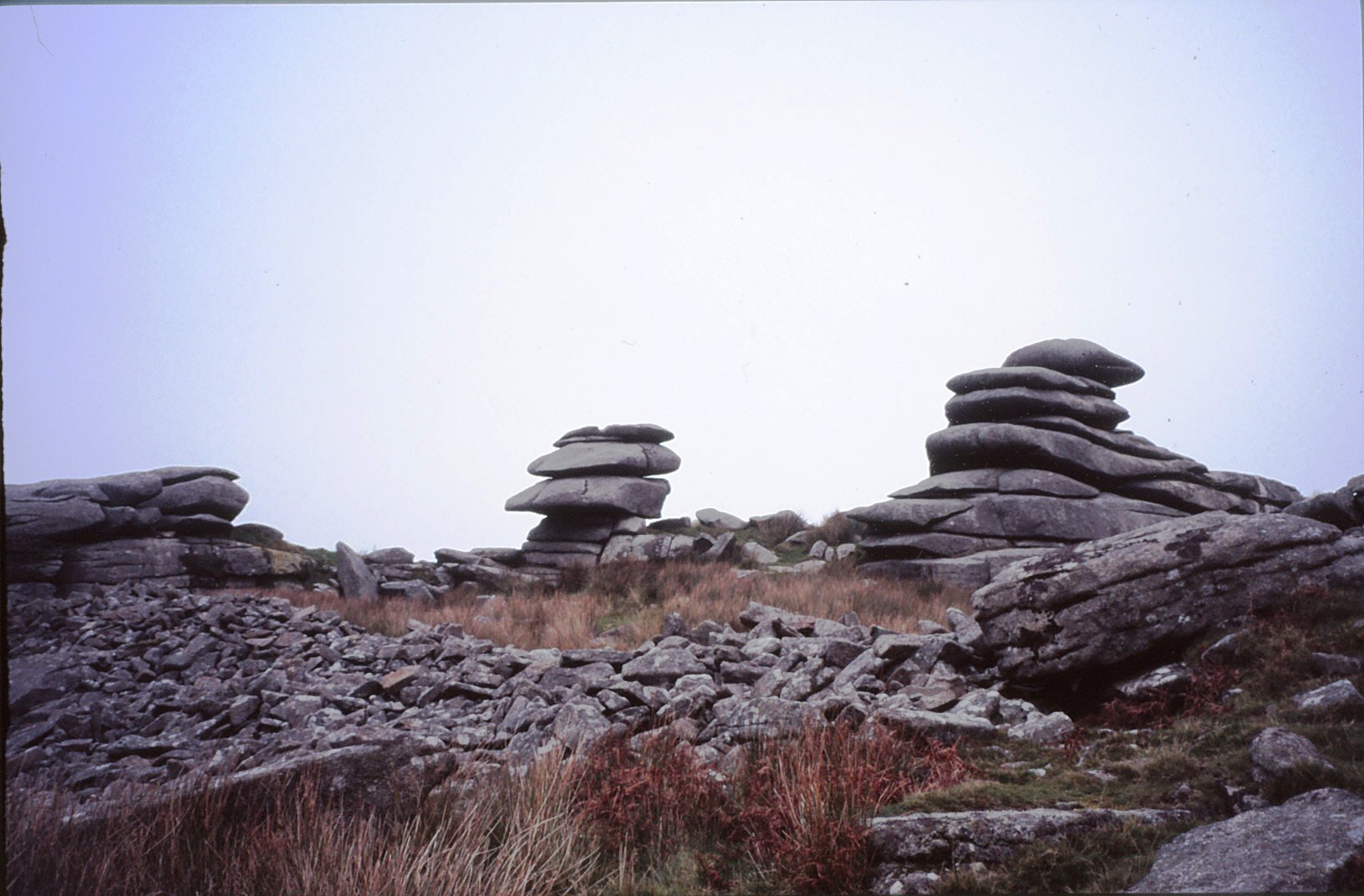
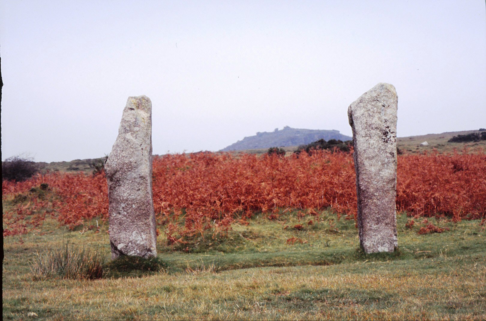
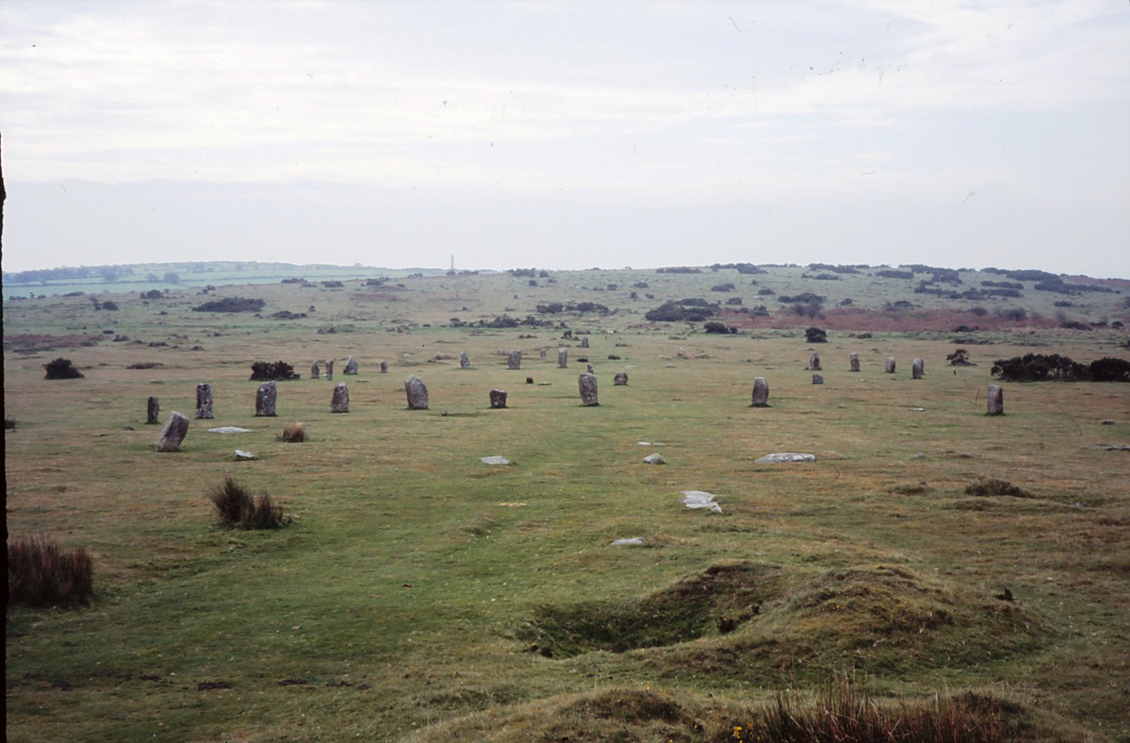
Yes I know this really is cheating…but no list of sites to visit is complete with at least one from Bodmin Moor. However the problem is I could not choose just one, there are so many wonderful sites to visit on the moor. Like its much larger cousin in the next county over, Dartmoor, Bodmin Moor has a wide variety of archaeological sites to visit beginning way back into the Mesolithic (flint scatters possible representing seasonal camps as found on Butterstor) and the Neolithic such as Stowes Pound and Rough Tor which are thought to be tor enclosures similar to Carn Brea and Trencrom further to the west, but it is the Bronze Age which dominates the archaeological record.
There are stone circles, stone rows, menhirs, barrows (earthen mounds), cairns (stone mounds) and of the latter there is in excess of 300 known. The most well known barrow is the Rillaton barrow which is the largest on the moor and where an individual was buried with a bronze dagger, an urn and a beaten gold cup.
“…the distribution of the monuments throughout the whole of the upland suggests that its use had intensified enormously. Virtually every block of land (as defined for example by prominent hills and divided by rivers and streams) is marked by a group of cairns, as if all available land was claimed and accounted for. The analysis of fossil pollens fromthe ancient land surfaces sealed beneath the excavated cairns shows that by this date the upland was predominantly open grassland, with woodland confined to the steep valley sides.” (Herring P & Rose P Bodmin Moors Archaeological Heritage pp17-18)
There are sixteen known stone circles of which the best known is the Hurlers. All the circles seem to have been placed carefully within the landscape – nearly all are within sight of tor which is always to the north of the circle, with Roughtor being the most dominant (nine of the sixteen circles). The stone rows, menhirs and embanked avenues are not as numerous but still make up an important part of the ritual landscape.
A feature of the later Bronze Age landscape of the moor is represented by the vast numbers of settlements represented by field walls and the stone foundations of round houses. There are approximately 1500 prehistoric round houses representing around 200 settlements and although only three have been excavated they are assumed to be all by analogy with Dartmoor to belong in the second millenium BC. Often found associated with these settements are field systems of varying shape and size best seen from the air and on large scale maps.
Ar around 1000BC a deteriorating climate and soils resulted in most settlements being abandoned and the use of the moor being less intensive. The hillfort sites of Bury Castle, Cardinham and Berry Castle are the only easily identifiable settlements of the Iron Age, although it is assumed that the moor continued to be used for the seasonal grazing of livestock, much as parts of it are today.
Rowe T M (2005) Cornwall in Prehistory Tempus/History Press
Weatherhill C (2009) Cornovia Ancient Sites of Cornwall and Scilly Halsgrove
Johnson N & Rose P (2003) Cornwall’s Archaeological Heritage Twelveheads Press
Herring P & Rose P (2001) Bodmin Moor’s Archaeological Heritage Cornwall County Council


