Avebury – the largest stone circle in Europe. It is an easy platitude and just as easily the visitor can wander around the giant stones, exclaiming, wondering why and who built the circle. Then with equal ease get back in their car/tour bus, tick it off the bucket list and move on. However, stop for a moment, look around, peruse the maps and the visitor will see Avebury sits within landscape full of engimatic archaeological sites – West Kennet long barrow and Avenue, Silbury Hill, Windmill Hill, the Sanctuary to name a few. Avebury, the largest stone circle in Europe is but a single element of a much wider sacred landscape.
In fact the Avebury landscape can lay claim to having the largest human constructed mound in Europe (Silbury Hill); the largest long barrow in Britian (West Kennet); one of the largest settlement sites of the earlier Neolithic in Britian (Windmill Hill) and the remains of the longest known avenue of standing stones in Britian (West Kennet Avenue). It would be easy to think that the people of Neolithic Avebury had something to prove but that would be putting modern thoughts of competition into a mindset many thousands of years old.
But lets not jump the gun, first consider what came before the Neolithic and then look at each of the sites individually.
Hunter gatherers in Avebury
To date no single site has been discovered which can be dated to the Mesolithic. In fact the hunter gatherer forebears of Avebury offer up very little in the way of evidence to say ‘we were here’. At the most, isolated findspots of flint tools are known and even these are sparse with just over thirty being recorded. However as many a archaeological lecturer will point out ‘absence of evidence does not equal evidence of absence’.
“As a landscape it is not necessarily empty of significance. There is plentiful ethnographic evidence to show how hunter-gatherer communities invest landscapes with symbolic, mythical and narrative meanings” (Pollard J & Reynolds A ‘Avebury. The Biography of a Landscape’ 2002).
Whilst it might not be obvious to modern eyes the positioning of sites in the earlier Neolithic may well be based on long term community memories, stories and myths which stretch back into the Mesolithic. The simple passing of time reinforcing the importance of place.
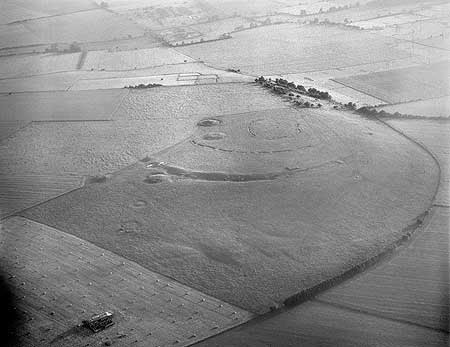
Windmill Hill
Windmill Hill was in use long before the Avebury of today was constructed and is one of a group of early Neolithic monuments known collectively as causewayed enclosures. Numerous examples are known across Britain and although they vary in size and geography there defining feature are the concentric rings of ditches with multiple ’causeways’.
“As the earliest recorded monuments designed to enclose open space, causewayed enclosures represent an unprecedented phenomenon in the archaeological record of the British Isles. The deliberate deposition of artefacts and other cultural material into features dug into the ground represents another important new departure. The creation of the monuments – especially the initial act of defining a place as seperate from the outside world – has therefor increasingly been stressed as a key aspect of their function.”
(Oswald A, Dyer C & Barber M ‘The Creation of Monuments: Neolithic Causewayed Enclosures in the British Isles’ 2001 English Heritage).
Windmill Hill consists of three concentric rings of ditches first dug between 3700-3500BC with a total area of around eight hectares. Within the Avebury area there are a further two similar but less well known enclosures dating to this early Neolithic phase – Knap Hill and Rybury. Windmill Hill has been excavated on several occasions beginning in the late 1920s by Alexander Keiller. Further excavations occured in 1957, 1958 and 1988.
The artefacts found during these excavations represent what can be seen as a microcosm of early Neolithic life. The large quantity of animal bones (mainly cattle) and over twenty thousand pottery sherds represent the importance of raising stock as well as food production and consumption, perhaps in the form of feasting. The one hundred thousand pieces of worked flint; worked sarsen stone; chalk artefacts; antler tools, human bone and axes made of non-local stone represent other aspects of exchange and manufacture; human interactions with the living and the dead.
Beyond the artefacts there is the enclosure itself – for the first time areas of the landscape are being seperated out from their surroundings. Whilst we cannot say for certain it is possible that Windmill Hill was already a place with special meaning and the bounding of the land gave the activities which occured here a greater significance. Evidence demonstrates that Windmill hill was not occupied all year round, most likely from spring to autumn.
“By providing a focus for people to come together on specific occasions, the creation and re-creation of the monuments may have helped to confirm links between groups and individuals, simultaneously establishing a place of lasting significance to all.” (ibid)
The importance of causewayed enclosures such as Windmill Hill should not be underestimated. Windmill Hill provides a point of origin for the development of the later ritual landscape all too evident in the Avebury area.
Listing on Pastscape
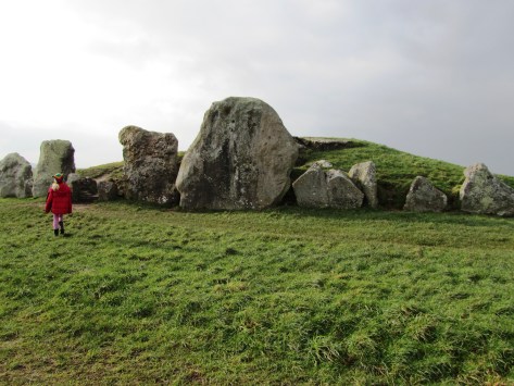
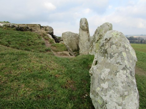
West Kennet Long Barrow
Long Barrows are another type of site which belong to the pre-Avebury stone circle phase and the early Neolithic. Consisting of trapezoidal or rectangular mounds of earth, turf and chalk. There are two types, megalithic or those with stone chambers and non-megalithic or earthen long barrows.


West Kennet is but one of fourteen long barrows known within a three mile radius of Avebury and is dated to around 3700BC – West Kennet however, is the longest (at 100m long) and the only one in the area which can be easily visited today. Belonging to a group known as the Cotswold-Severn type it was first excavated in 1859 and then in the late 1950s. It consists of five stone chambers connected by stone corridor at its eastern end. The chambers extend twelve metres into the mound and are fronted by an elaborate facade.

Human remains were found in all five chambers, which would definitely suggest a funerary function for the site. Initially these were placed in the chambers as whole bodies but over time these were moved around, re-organised and in some cases completely removed (perhaps finding their way to the ditches of Windmill Hill and the like). After the final internments and over several hundred years the chambers were filled in with chalk rubble, pottery debris, animal bones, bone beads, stone, shell and worked flint. Within and on top of this fill other human bones were discovered, mainly of children and most dating to a later period of around 3300BC. There were ten seperate and distinct layers suggesting that this was a deliberate act and not random.
As a final act in the late third millenium BC a facade of three large sarsen stones was built across the forecourt effectively blocking access into the tomb – this act was contemporary with the main stone phase of Avebury; “…closing the monument and marking the end of ‘an older tradition focussed on ancestors and the past'” (Pollard J & Reynolds A ‘Avebury: The Biography of a Landscape” 2002).
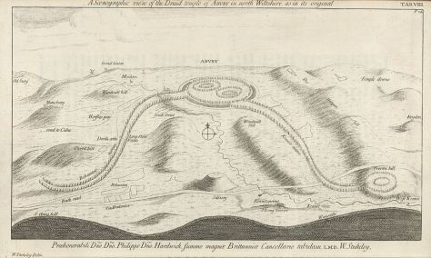
Avebury

Avebury is approximately 420 metres in diameter and encloses around 11.5 hectares. The bank is on the outside of the ditch and there are four entrances (SSE, WSW, NNW and ENE). The ditch today is four to five metres deep but originally it would have been ten to fourteen metres deep and although grassed over today when first dug the walls of the ditch would have gleamed white, a very obvious feature within the landscape. Contained within the ditch and bank is the largest stone circle in Britain and although many are now missing, it has been estimated that originally there would have been between 95-100 stones around the circumference of the ditch. The largest blocks flank the southern and northern entrances making the route into the centre sinous and not straightforward. At the northern entrance stands a huge stone sometimes referred to as the Diamond Stone and it weighs in at around sixty tonne. Up until the eighteenth century a taller straighter partner stood on the opposite side. The stones are sarsen, a hard grey sandstone with quartz grains. When freshly cut the stones would of looked very different to what they do today.
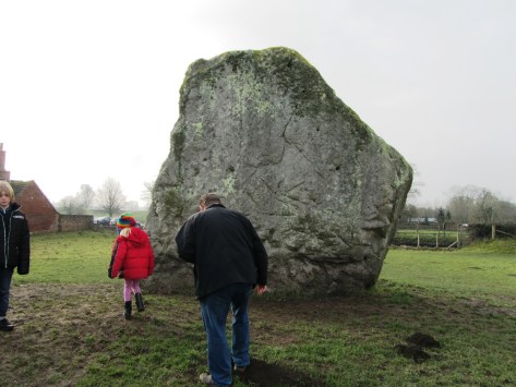
One of the most influential people in the recent history of Avebury was Alexander Keiller who undertook many of the excavations in the area during the 1930s and resurrected thirty six of the current stones. When he first bought the land only fifteen of the stones remained upright.
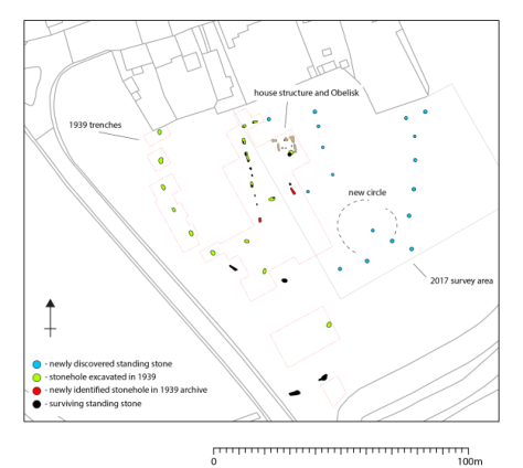
Within the larger circle there are two further smaller circles situated on the saddle of a crest over which the entire monument is situated. In their original form each circle would have had around 25-30 stones and a diameter of approximately 100 metres. In the centre of this were two further monuments referred to as the Cove and the Obelisk. The latter no longer exists but we know of due to William Stukeley who describes it as a pillar 5.5-6 metres high. The Cove are a box like setting of three stones of which only two still remain. In addition, fifteen metres to the west is a thirty two metre long row of nine small reddish stones; roughly half way between the southern small circle and the outer circle is another standing stone referred to as the Ring stone as it is naturally perforated. An aerial survey in 1995 identified numerous parchmarks which may represent more stones.


Further aerial work, geophysical survey and excavation have identified other features not of stone but of timber and earth. Not much can be said of these features in terms of character and date but it is likely some may be contemporary with Neolithic Avebury. For example, excavations in 1939 at the southern entrance uncovered a substantial 1 metre deep posthole suggesting a pre stone phase of timber posts. In the 1980s geophysical survey suggested the existence of multiple timber circle in the north-east quadrant about forty metres in diameter.
One notable feature of Avebury is the relative lack of prehistoric artefacts. When they are found during excavation they appear to be related to the earliest phases of the monument or its construction. The latter are often referred to as depositional deposits such as the antler picks used to dig the ditch which when the ditch was finished were then deposited on the base, in the primary fill and in the bank.
“We should avoid thinking of the construction of a monument like Avebury as a pragmatic process, as though the sanctity of the site was something conferred upon it once building was complete (not that for much of its early life is ever was). The process of digging ditches, creating banks, dragging in and erecting stones, of ‘altering the earth’, was fundamentally significant in itself – a direct intervention into nature and the cosmos. Indeed, the act of building may have been of as much significance as any completed project.” (Pollard J & Reynolds A ‘Avebury The Biography of a Landscape’)

Other deposits are found in stone holes or around stones, although only in some parts of the circle. For example, excavations of the southern Inner Circle found a concentration of worked flint particularly around the Obelisk. The south-west sector by comparison was almost clean of artefacts. In the north-west quadrant a variety of artefacts were recovered including sherds of Grooved Ware, human and animal bone, flint flakes, fragments of axes and sandstone implements. Much of this material appears to have been brought in from elsewhere and some are even older than the date deposition.
Of course, all of this is very interesting but what was it used for? Which is of course a million dollar question…interpretations vary and as more research is conducted and more information comes to light so the interpretations change or are tweaked.
The variety of theories include rituals to celebrate certain times of the year; death; transitional periods within life; making contact with the ancestors or the supernatural. Such activities may have been perceived to be dangerous times and hence the act of enclosing the site kept the people safe. Francis Pryor has suggested that the bank outside the ditch allowed people to witness the activities in the interior but at the same time excluded them by the presence of the ditch. The lack of artefacts inside the circle also suggests that this was not a space for just anybody to occupy.
“In one form or another Avebury succeeded the earlier enclosure to the north on Windmill Hill. Both were locations for the periodic gatherings of large numbers of people; these gatherings involved the deliberate burial of artefacts, animal and human remains (though on a much reduced scale at Avebury); at both sites people were involved in a dialogue with spiritual and supernatural agencies…Avebury is more formalised in terms of architecture, and more restricted in terms of how it could be entered and encountered than Windmill Hill – it is less inclusive. But, like Windmill Hill, Avebury also incorporated references to the wider Neolithic social world and surrounding landscape.” (Pollard J & Reynolds A – Avebury. The biography of a landscape.)
Most recently news has come to light of an unusual feature within the centre of the southern inner circle. A research team led by the University of Leicester and University of Southhampton found a series of stone holes which formed a square shaped monument around the now lost Obelisk. Although currently undated, it has been suggested that this may be the oldest part of the entire site and may even be a form of dedication to an even earlier house structure. Only excavation will answer these questions and once again our understanding of this site will need re-evaluating. The team also found evidence for short lines of stones which radiated out from the square to edge of the inner circle.
Squaring the Circle – a blog from FragmeNTS regarding the square monument at Avebury.
The Avenues
In the later part of the Neolithic another type of megalithic monument emerged in the landscape – the Avenues. Leading from the henge at Avebury were two double lines of megalithic stones, one heading from the southern entrance – the West Kennet Avenue; the second heading from the western entrance – the Beckhampton Avenue. Of the two only the West Kennet can be easily walked today.
Both avenues are similar in construction – each are around fifteen metres wide and consist of paired of sarsen blocks that have not been modified. The stones are set every 20 – 30 metres and are around 1.5 – 3 metres tall. The West Kennet leads to the site known as the Sanctuary on Overton Hill and is made up of around one hundred stones. It has been suggested that the avenues were not laid out in one go but were constructed in a series of stages. Dating of the avenues has been relatively problematic due the ‘clean’ nature of the sites, although the Beckhampton Avenue is regarded as being the later monument – but not by much. The current date range is between c.2600-2300BC.
The full length of the Beckhampton Avenue is not yet known and was first recorded by William Stukeley in the 1720s and even then it was in a very sorry state. By the nineteenth century only two stones remained upright known as the Longstones (or Adam and Eve). For many years there was some doubt as to what Stukeley recorded but excavations in 1999 and 2000 proved the presence of the avenue and an associated Cove at the Longstones. This area of the Beckhampton avenue underwent a series of changes and readjustments overtime eventually ending with a box shaped setting of stones forming a terminal end to the Avenue.
In regards to purpose it is fair to say that the avenues represent a need to prescribe particular pathways of movement and approach to and from Avebury. It has also been suggested that the processional ways are all about social grading – someone is always in the lead whilst others must follow. In addition, the movement through the landscape also serves as a form of remembrance – linking significant places of cultural memory together.
“At another level, the avenues transformed a landscape of scattered monuments and significant places into a unified complex that was to be approached, read and understood in a very particular way.” (Pollard & Reynold ibid).
The Sanctuary
As mentioned above the Sanctuary is connected to Avebury via the West Kennet Avenue. Located on the southern spur of Overton Hill it is a complex monument which began life as a circle of timber posts roughly twenty metres in diameter, later becoming a larger double stone circle monument. Although our understanding of the constructional history is not complete it does seem as if many of the timber posts remained in situ during the construction of the stone circles and beyond. Giving an image of a ‘confusing mass of posts’ in both timber and stone. Today the site is marked by two rings of low concrete posts. In the 1720s the field was taken under the plough and the stone removed.
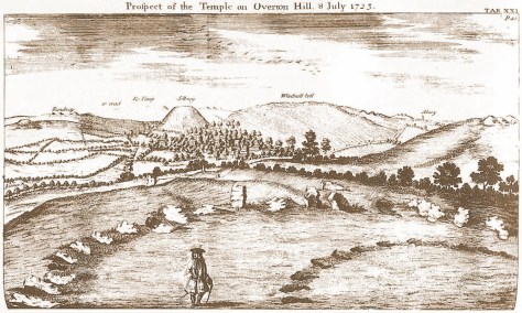
However, it’s importance must not be underestimated. With commanding views along the Kennet valley, the long barrows at East and West Kennet are visible as is Windmill Hill. In addition, there is a long history of activity on the site stretching back into the fourth millenium BC. The most predominant artefact type found on site is flint knapping debris and animal bone, although finds of pottery and human bone were also found as formalised deposits.
Silbury Hill
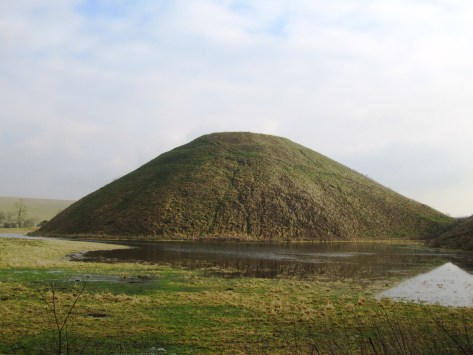
Thirty seven metres high, thirty metres across at the top and five hundred metres around the base – Silbury Hill is the largest prehistoric human made mound in Europe and probably the most enigmatic too. It sits on the valley floor close to where the River Kennet rises at the Swallowhead Springs. It seems the construction of the site began around 2400BC although an end date is even less certain. Many attempts have been made to tunnel in to see if anything lies inside and as of yet nothing has been found. Work in 2007 suggests that the mound grew as a result of many small events, giving an image of pilgrimage.
As to its purpose, well…
Final words
There are of course many more monuments within the Avebury landscape – the West Kennet Enclosures; Knap Hill; barrows and other stone circles at places like Winterbourne Bassett – but unfortunately this blog post is already long enough. If you are interested then I do recommend reading Avebury. The Biography of a Landscape by Joshua Pollard and Andrew Reynolds. But most of all I do encourage you to get out and see these places for yourself – it is through experiencing the places of our past do we begin to get a glimmer of understanding.
The following are some online sites that may be of interest:
Avebury: A Present from the Past


Postscript – from the Telegraph today we learn that a ‘5000 year old house of the dead’ in the Vale of Pewsey (half way between Avebury and Stonehenge) is to be fully excavated.