Tag Archives: Mesolithic

Saveock – An Archaeological Mystery…

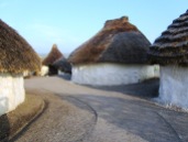
Going to Saveock is a bit like travelling back in time, seeing a peep of a thatched roundhouse roof only adds to the impression that you are somewhere else. Originally you would have had to wait on the other side of the train tracks, call the main station to see if any trains were coming and if they gave the all clear, open both sides of the gate then speed across – they had been known on the rare occasion to get it wrong. Today though there is a much safer way of getting into Saveock, a suitably narrow hedge lined drive leads down to the small holding and even though it is only a fifteen minute drive from Cornwall’s main city of Truro, it feels remote and tranquil – timeless.

So,where is Saveock?  Well, it is a small holding situated in a tranquil river valley near Truro in Cornwall.  On arrival at Saveock you are met with the ever smiling Jacqui Wood who is not only a well known and respected experimental archaeologist (did I mention the roundhouse?) and author of several books including Cliff Dreamer: The Goddess Returns, a new fictional story set in the turbulent times of our very distant ancestors. She also runs the Saveock Water Archaeology Centre where students of archaeology (age and experience no barrier) are instructed in the art of excavation, here they find their minds being opened to the endless possibilities that the study of the past can present to those willing to listen.

I met Jacqui some fifteen years ago when during a chance conversation she told me about some curious stake holes, a green clay floor and associated flint tools which she happened upon whilst digging a flue to conduct an experiment in tin extraction. At the time I was teaching A level Archaeology and we thought it would be a good chance for the students to learn some excavation techniques in the field, after all in archaeology practical experience is far more useful way to learn. It was the beginning of many seasons of excavation, intriguing finds, the remodelling of cow shed to comfy quarters for the diggers and much more. My eldest spent the first few months of his life sleeping safely at the edge of a trench.


taking-another-slice-of-tre
Volunteers and students at the trench face.

The site at Saveock covers a wide range of time as you would expect of a small river valley in the heart of Cornwall with fertile soils, natural springs and near a well known source of tin and possibly gold. The earliest phase belongs to the Mesolithic, the evidence for which comes firmly from those aforementioned stake holes, green clay floor and the associated flints.

 
“In the Mesolithic the main site trench was over a south facing peat bank on the bend of a river that was between two shallow lakes. This entire site has been purposely covered with various different coloured clays in an attempt to make the river bank a suitable place for dwellings. In the area A/2 the first phase of the site, is what we believe to be a Mesolithic dwelling platform covered with dense green clay surrounded by stony yellow clay in which the stakes to support the dwelling were driven.” (Jacqui Wood).
The second phase was and still is a bit confusing but it does seem entirely possible that it belongs in the Neolithic. When excavating it had been our intention to extend the trench to get a better picture of the Mesolithic features, so imagine our surprise when we came across a stone lined and capped drain covered in thick green clay that lead in one direction towards the river and in the other to another feature, rectangular in shape and lined with white quartz stones and spring fed. Several seasons later in 2005 Jacqui and her team uncovered another similar feature adjacent to the first original ‘pool’.
Dating the pool feature was problematic as it seemed to have been used over a long period of time.

B2-insidedrydrain
Inside the stone capped drain looking roughly north.

The only other similar feature we have found was the platform around the Neolithic monument of Maeshowe in Orkney. This platform was made up of thick clay and when a trench was put through it a stone lined and capped drain was discovered which was almost identical to the one at Saveock. The presence of the quartz stone too would suggest a very early date, the use of quartz in Neolithic and Bronze Age ritual sites is well attested to. The pool itself became known as the ‘moon pool’ as the white quartz glows in the bright moonlight.
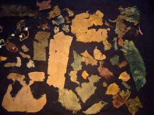
As for its function, well ritual seems a good an answer as any other but only because there appears to be no other alternative and believe me we considered a wide range of alternatives. Jacqui herself was always of the opinion that the word ‘ritual’ was used far too loosely in archaeological circles to explain seemingly unexplainable objects or sites. Later post excavation work on the mud we scooped up from the bottom of the pool (it couldn’t be excavated in the traditional manner as it kept filling with water) revealed some small finds which told a story of long usage and deposition.  These included human hair, fingernails, Medieval straight pins, 128 small pieces of textile, parts of shoes, heather branches and perhaps most interesting was the broken half of iron pot or cauldron.


Many of these finds seemed to date to the last phase of usage at a time just before the pool was filled in and covered, a deliberate act to erase a pagan site. The lack of any finds earlier than the late Medieval may suggest that intervals the pool was clean out – thousands of years of deposition, not to mention silt, would have filled the pool considerably if it was not cleaned out regularly. Interestingly, in the layer just above the infill layer a broken glass bottle and a few sherds of pottery dated the closure of the pool to around the time of the English Civil War. Cornwall was at the time and even today a place where the rituals of time past were an important part of local society often overlooked by the Church. Cromwell’s puritan army would not have been so kind to Royalist (and pagan) Cornwall.

Perhaps one of the most intriguing episodes in the sites history comes from once more as a result of an extension of the trench with the Mesolithic features this time along the edge towards the marsh by the river. Whilst following the expected green clay floor and associated stake holes we encountered shallow pits with unusual contents cut into the clay floor. Because this area is essentially a waterlogged part of the site organic remains survived particularly well.


Area-L-2
The clay floor with pits.

“When we excavated the first one we were surprised to find white feathers in it and thought it might have been perhaps a bird plucking pit, which was a common farming practice at the turn of the century. This turned out not to be the case when we found that the feathers were not plucked, but had been laid skin side out with white feathers inside. We took samples of the feathers to the bird expert at the local zoo and found them to be swan feathers.” (Jacqui Wood).

 
In addition a small amount of tiny stones were found surrounded by some sort of organic matter. Initially the assumption was that this was the crop of the swan but the stones were too pristine and it was concluded that the stones had been wrapped in leaves and deposited on purpose alongside claws from a range of other birds. The stones themselves were of an interest as they appeared to be brought to the site as they contained tiny nodules of beach flint an unusual feature given how far inland Saveock is. A suggestion from a local had us mounting an expedition to Swan Pool, some fifteen miles away on the coast and sure enough the stones at Swan Pool were identical to our small sample. Radiocarbon dates from the swan skin dated the pit to the 1640s, once again it seems dangerous ritual activities are occurring at a time when to be called a witch would mean certain death.


3)-egg-pit-9
A pit being excavated.


A further eight pits were excavated that season, only two of them were intact the other six had had their contents removed in antiquity leaving just a few feathers and stones to show what their previous fill was. Excavation of this area was tough going, a thick layer of reeds impeded the work and as time went on more pits would be found, all with their contents removed that was until 2005 (two years after the first pit had been discovered).
Three pits were found in a row, two rectangular and one round in the middle. Of the three it was decided to excavate the middle round one, here the dig crew found the pit to be lined once again with swan feathers but also on either side the bodies of two magpies. In the midst of this were the remains of over fifty-five eggs and although the shells had rotted away the membranes were remaining. The eggs themselves appear to have come from a variety of birds, some even had full formed chicks ready to hatch inside them still.

2)-chicks-in-eggs-from-pit
The egg membranes with chicks…

Further pits revealed the remains of a cat and dog skull.  Perhaps the most astounding part of this whole story is the radiocarbon dates for the cat pit which was dated to around the mid 18th century and the dog pit which had a date of circa 1950s.

But as archaeologists we need to ask why? What was the purpose of the pits? There is the suggestion that these are the result of witchcraft based rituals and conversations with many experts in the field of witchcraft have yielded very little to enlighten us. If these pits are connected in some way to witchcraft or even pagan rituals of a different kind it is not one commonly known. This is not too surprising given that so much knowledge about traditions and rituals has faded away. Jacqui though has her own theory as to who and why;
“My own theory (and it is only a theory) is that maybe if you got married and did not get pregnant in the first year, you might make an offering to St. Bride of a feather pit. If you finally got pregnant you had to go back to the pit and take out the contents and burn them and set the spirit of the swan free. If you never got pregnant then the pit remained untouched.”

Saint Bride or Brigit has many similarities to the Celtic deity of Brigid. The first of February is St Brigids feast day but also Imbolc where the goddess Brigid is remembered as one who brings the spring. Both are associated with healing, poetry and other domestic tasks. There is also a connection with the sacred wells. Today well dressing is done in the name of the Saint. Wells have long been a place of veneration, our modern wishing wells merely a continuation of a ritual act of deposition that begun in the Bronze Age if not earlier. The connection with the goddess and the saint at Saveock is slight but as we all know it is a place to start.

On a personal note I should like to mention that when the quartz lined pool was excavated it was myself and a friend who did the digging (we were the only ones willing to get so mucky). We spent the good part of a week in the mud and spring water. In late November of that same year I discovered I was pregnant with my eldest (who incidentally was born at midsummer) and a few days later my friend who had been digging too told me she too was pregnant – our children were born just a week apart.
More recent excavations have been looking in a completely different area of the farm and this time they have uncovered a hearth edged with smoky quartz crystals. Dating was provided by the large quantities of Bronze Age pottery found in association with the hearth. Work at Saveock is never dull but it is ongoing, so if you fancy have a holiday with a difference then check out the link below.


Jacqui Wood 1
Jacqui excavating one of the pits.


For more information on the Saveock Water Archaeology Centre please go to the website www.archaeologyonline.org
Jacqui Wood’s book Cliff Dreamers is available to buy on Amazon along with her book on food through the ages Tasting the Past. Jacqui also has numerous articles published many of which can be found at www.academia.edu

Please Note – all photos except the featured image at the top of the article were provided by Jacqui Wood and the copyright belongs to her.  The featured image at the top of the article is my own.

This article originally appeared in the Celtic Guide magazine December 2016.

Stonehenge – more than a ring of stones.

Stonehenge – a name that evokes a great many emotions in a great many people.  For some it is a place of pilgrimage, a place to connect with the ancestors and for others it is seen as a tourist trap or something to tick off the bucket list.  For centuries it has captured our imagination; never has a heritage site been so controversial – something which continues to this day.  In this post it is not my intention to give a full on thesis about Stonehenge, there are plenty of books/websites who do this already.  Instead it is simply an overview of what is currently understood about the site, its surrounding landscape and my own personal thoughts.

Stonehenge is situated on the Salisbury Plains, to the south is the busy A303, a main road between the south-west and London, and for many years the equally busy A344 ran alongside the site.  This latter road was removed sometime ago to improve the visitors experience.  Today there are ongoing discussions regarding the upgrading of the A303 and a proposed tunnel.  It is a highly emotive subject, on one hand I understand the need to improve the road situation (ask anyone who is stuck in a traffic jam on the A303) but as an archaeologist I am also aware of the sensitive nature of the surrounding heritage landscape (and yes I am on the fence).  Mike Pitts in his recent post discusses the pros and cons for those of you who are interested.

img_7543

For the visitor today the focus is on the large stone circle with its trilithons, they marvel at how it could have been built by ‘primitive man’ often leading to suggestions of alien intervention and lost technologies.  But such thoughts only serve to belittle our ancestors and our past.  Others may ask why did our ancestors build Stonehenge?  Often the answers are unimaginative and simple – sun-worship; display of power; ancient computer; druid temple – once more when we look only for one answer to a what is obviously a complicated site of great longevity we belittle their achievements.  Instead if Stonehenge was understood in terms of the wider landscape and as a site whose history spanned several millenia we might come to some small understanding of how and why.

In today’s world of instant gratification where everything has a beginning and an end,  it is hard to imagine beginning a project knowing you might not see it finished but this was a reality for the builders of Stonehenge.  It has lead some to suggest that it was not the end product which was important but the doing, the act of building which was in fact the purpose.  Suggesting a cyclical thought pattern which can be seen in other aspects of prehistoric life – round houses, stone circles, round barrows.  in addition, time itself was most likely viewed in cycles, the phases of the moon and the movement of the seasons are all cyclical events which would have been of great importance to prehistoric people trying to make sense of their world.

“So was Stonehenge ever ‘finished’?  The answer to that has to be no, because completion was never the intention of the people who created it.” (Pryor F. 2016 ‘Stonehenge: The Story of a Sacred Landscape).

It is well known that Stonehenge itself had many incarnations, perhaps meaning new and different things with each alteration or rebuild.  To understand Stonehenge it is important to consider it in the wider context of the surrounding landscape (there are literally hundreds of prehistoric monuments around it) in all the different phases.

The Mesolithic Story

The story of the Stonehenge landscape begins back in the Mesolithic, ongoing recent excavations at Blickmead are providing archaeologists with tantalising clues as to why this area was important to our ancestors.  The site is situated near a spring by the River Avon, excavations began in 2005 and almost immediately were fruitful.  Basically, the deposits consisted of an array of Mesolithic settlement debris, mostly flint fragments (tens of thousands) but also a great number of animal bones.  Interestingly, the site also yielded the largest collection of auroch bones ever found on a Mesolithic site in Britain so far.  Other animals which were hunted and consumed included red deer, wild boar and salmon – this has led archaeologists to suggest that feasting was a common occurence around the spring.  The spring itself is quite unusual as it has the tendency to stain flints and other materials a bright magenta pink – the importance of springs in later prehistory is well attested to.

70334941656960

In 1966 row of four large pit like features were found during upgrades to the old carpark close by Stonehenge.  When excavated one was found to be a the root-hole of a tree and the other three were holes dugs to hold large poles.   Examination of the material from these features gave a date range from between 8500 and 7000BC.  The posts would have been approximately 75cm in diameter and were from pine trees.  Later in 1988 another post-hole was discovered south and east of the original pits but it was contemporary.

So here we have a landscape already well populated by hunter-gatherer communities who revered certain natural features long before Stonehenge makes an appearance.  A landscape which had meaning to the people who inhabit it; who had traditions and memories of place.

At around 3500BC (Neolithic) with the arrival of farming these communities and their traditions had evolved and more permenant features began to make an appearance on the landscape.   Long barrows such as those at East and West Kennet or Winterbourne Stoke were the first to appear and by 3400BC the Stonehenge Cursus and Lesser Cursus was under construction.

Houghton_Arc_855.214_-_Stukely,_the_Druid_temple_of_Abury

3000BC – The first official phase of construction

In many parts of Britian at this time a new type of monument was being constructed, these were earthwork enclosures which are referred to as henges.  They consist of irregular cut ditches encircling a defined area with corresponding banks.  Stonehenge’s earliest phase was one such earthwork.  Here there were two entrances one faced north-east and the other faced south.  The north-easterly entrance remained in use for much of the sites lifetime and appears to be important to its function.  The entrance is aligned along a line of natural gullies which face towards the midsummer sunrise in one direction and the midwinter sunset in the other.


img_7542
The bank and ditch of the first phase of construction – often overlooked by the visitor as they focus on the stones.


These natural gullies would have been visible to the people of the Mesolithic and may have been why the large pine posts were erected where they were – the midsummer and midwinter solstices were just as important then as they were to the later prehistoric communities.

Inside the earthwork enclosure around the inner edge of the bank were fifty-six regularly spaced pits – these are now known as the Aubrey Holes.  There is some discussion as to what they were or what they contained – small stone uprights or wooden posts?  However, what is known is that eventually they did contain cremated human remains.  Similar deposits have been found in the partly filled ditch and cut into the bank suggesting that at this stage in its history Stonehenge was used as a cemetary, among other things.


img_7537
These circular markers define the spot where an Abrey Hole can be found.


The Building of the Stone Monument

At around 2500BC Stonehenge began to resemble a site we are much more familiar with. It is at this time that the massive sarsen stones from the Marlborough Downs were moved to the site and erected.  If that was not all at the same time the smaller but no less cumbersome, blue stones from the Preseli Mountains in Wales were transported and erected at Stonehenge.  The Heel stone was moved to its current position and four smaller sarsen stones (the station stones) were erected  inside the enclosure just inside the bank.

700251477253807002510254766070025459156180

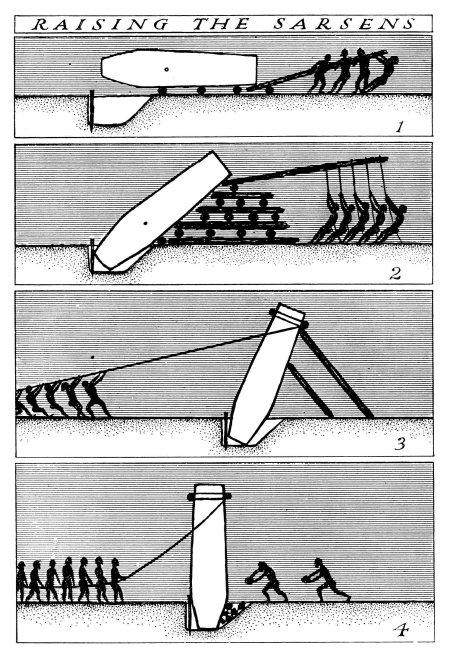
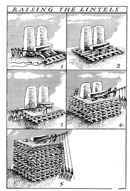
The first two diagrams above demonstrate one theory of how the trilithon stones were erected.  The third diagram shows the sophistication of the construction, with each lintel fitting neatly into each other – borrowed from the Univeristy of Buckingham’s MOOC “Stonehenge”.


img_7536
The friendly raven accentuating the knob which would have ensured a lintel that did not move.


stonehenge 1917
Stonehenge in 1917 – taken from a hot air balloon.


In a mere one hundred years it seems the two main structures of the trilithon horseshoe and the circle was completed. Interestingly it seems that greater care was taken in the shaping and construction of the stones visible from the north-east side and the main entrance.  The bluestones were also erected at this time but not in the form we see today at Stonehenge.  Excavation has shown us that there were two concentric arcs of stone holes, known as the Q and R holes were found on the north and east sides of the central area.  It has been suggested that these were not representative of a complete circle as there is little to no evidence on the southern or western sides of corresponding holes.


img_7544
The Heel stone – it is thought that unlike the other sarsen stones which come from the Marlborough Downs, the Heel stone was always here and simply raised upright.


2200BC – Consolidation and Alterations

From this time on Stonehenge underwent a series of minor alterations although the large sarsen stones remained in their positions although much later in the Bronze Age shallow carvings of axeheads and the occasional dagger were added.  There are some 115 carvings and these have been dated stylistically to between 1750 and 1500BC.

The smaller bluestones however were rearranged and by 2200BC the incomplete circles were dismantled and repositioned to form a circle concentric to and just inside the circle of larger sarsen circle whilst a second oval of bluestones (spotted dolerite) was also formed within the trilithon setting.  Later a number of stones were removed from the oval to form the horseshoe setting which is seen today.


img_7541
The smaller stones are the remnants of the bluestone circle.


At around the same time the ditch was recut and a small bank was constructed and the Avenue was constructed.  This later feature follows the solstice alignment with ditches and banks for part of the way and then veers off to the east ending in a valley of the River Avon.  Recent excavations at the place where the Avenue meets the River Avon have uncovered evidence for a previously unknown henge monument made up of bluestones. These were likely to have been removed to supplement the bluestones already at Stonehenge.

Surrounding the monument are significant numbers of round barrows dating from the Bronze Age, some of which contained rich burials with artefacts made of bronze, gold, jet and amber.  Suggesting a society rather different from the one which was able to come together communally to construct Stonehenge and yet the place, the landscape and the site still had a powerful pull to these people – it is no different today…

Above are two of the many round barrows littering the landscape around Stonehenge.

stonehenge landscape after Aubrey Burl 1955
A map showing the distribuiton of barrows in the Stonehenge landscape.

The pictures above show a reconstruction of houses found during excavations at Durrington Walls which date to approximately the same time as when the main phase of construction at Stonehenge was underway.  It is interesting to note the layout of the houses with the ‘dresser’ opposite the door and the beds to the right as you enter.  This layout is reminiscent of house layouts at Skara Brae and later similar layouts are seen in Bronze Age roundhouses.

This slideshow requires JavaScript.


Stonehenge is a UNESCO World Heritage Site, it is one of the most popular tourist attractions in Britain; it evokes a variety of emotions; it is a British icon and yet so many people still only today see the stones.  Yes they are impressive but there is so much more to their story than what you see.  To really understand Stonehenge the curious need to look at the wider landscape and then look further again.  Afterall, not too far away is the equally astounding landscape surrounding Avebury.  What was the relationship between these two sacred landscapes?  What can they tell us about the people who lived at the time?  These landscapes were created by a people who viewed the world very differently to ourselves and carry a language, a dialogue that would have been obvious to those who lived in the Neolithic and even the Bronze Age.  In our modern world where landscapes are viewed as places to use – either to make money or in terms of leisure pursuits – it is often hard for us to step back in time to view the landscape as living breathing entity without which we could not survive.

Stonehenge and its surrounding landscape undoubtedly meant many things to the people who occupied it (and probably those further afield too), the stones themselves were taken from the land and perhaps used to create a space where the natural world could be contained; where a semblance of control was maintained; where perhaps a balance was found between the natural world and the constructed world.

There are a great deal of books and websites which delve into the Stonehenge enigma in far greater detail.  I have listed some of those below (browse Amazon for comprehensive lists).  In particular I would like to recommend the free online course run by Buckingham University via Iversity (click here for more details).

Further Reading

Pryor F (2016) Stonehenge: The Story of a Sacred Landscape

Parker-Pearson M  et al (2015) Stonehenge: Making Sense of Prehistoric Mystery

Parker Pearson M (2013) Stonehenge: Exploring the Greatest Stone Age Mystery

Bowden M et al (2015) The Stonehenge Landscape: Analysing the Stonehenge World Heritage Site.