If archaeology is your thing (and it’s certainly mine) then Cornwall is a great county to visit with a mulititude of sites to visit, especially if you want to get away from the crowds and sitting on the beach has lost its appeal. From the outset I should point out the following are my favourite sites/landscapes to visit (it was quite difficult to keep it to just ten and yes they are mostly prehistoric sites), others may have different views – the list is purely my own opinion. Feel free to comment on your favourites.
1. Chun Castle and Quoit
Okay so I have cheated a bit – here we have two very different sites but their proximity to each other I think allows for a bit of cheating…
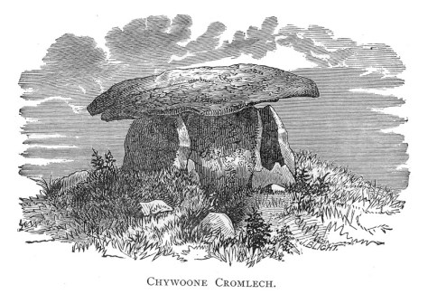
Firstly, Chun Quoit – quoits are neolithic monuments found throughout Cornwall (there are about a dozen known sites) consisting of upright granite slabs topped by a large capstone. They can also be called portal dolmens, chamber tombs or cromlechs. Some are in a better state of repair than others and Chun Quoit is perhaps one of the few which has been interferred with the least. Chun Quoit consists of four large uprights supporting a capstone which is estimated to weigh over 8 tonnes. It is also possible to see the remains of a circular stone cairn and associated kerbstones (the stone rubble at ground level) which would have originally surrounded the Quoit but not covering it leaving a the facade and the capstone visible.
Two hundred metres to the east of the quoit are the impressive remains of Chun Castle. Unlike many other Iron Age hillforts which utilise an earthen ditch and bank system Chun Castle is entirely stone built. It consists of two large concentric stone walls and is 85 metres in diameter. There is some evidence that the hillfort was built over an earlier enclosure represented by a shallow ditch and low bank on the southwest side. Inside the hillfort there is a stone lined well and escavations during the late 1920s found evidence for a later post Roman occupation of the hill fort. Iron Age occupation consisted of at least a dozen round houses which based on the pottery found date the site to the 3rd and 2nd centuries BC. Sitting high on the ridgeway known as the Tinners Way the site would have been visible from many miles around, from here it is possible to make out several other hillforts in the distance such as Caer Bran. Below the hillfort about 500metres to the north east is the site of Bosullow Trehyllys – a courtyard house settlement of the late Iron Age (see the earlier post on Chysauster and Carn Euny), it is unexcavated but appears to consist of at least three detached courtyard houses and a number of round houses.


2. Chysauster
I wanted to include a courtyard house settlement in the list and it was a choice between Carn Euny and Chysauster. In the end Chysauster won mainly because it is easier to get to but also because the visitor can get a good idea of size of this unique house type. However, I would recommend a visit to Carn Euny too – the fogou makes it well worth while. I have discussed both sites already in a previous post – Chysauster and Carn Euny – A Unique Settlement Type – so won’t say much more than that.


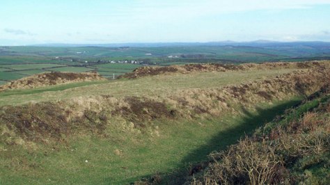
3. Treryn Dinas
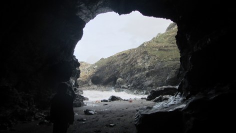
Treryn Dinas falls into the category of Iron Age cliff castle or promontory fort – one of many coastal headlands with Iron Age defences in the form of earthen or stone ramparts and external ditches usually across the neck of the headland. The term ‘cliff castle’ does not denote a particular function, some were large enough to have settlements within their walls, such as The Rumps and Trevelgue Head, others were much smaller and perhaps served as trading posts or lookouts. Treryn Dinas, however, appears to more than that – the visitor only need to look at the position and surroundings of this site to realise it is special.
Overlooking the beach at Porthcurno, the ramparts enclose a large rocky headland which contains the Logan Rock – a substantial boulder perched on the outcrop which in times past would rock in the wind and was only dislodged in 1824 by cocky young lieutenant and the crew of the HMS Nimble. The local people were rightfully upset at this and the lieutenant was charged to replace the rock at his own expense and with the help of the admiralty it was eventually returned to its original position, although it is said to no longer rock as easily as it had done once before.
According to folklore the earliest inhabitants of the headland were the giants who protected the neighbouring communities in return for cattle and other necessaries. Giants are a common feature in Cornish folkore and seem to be particularly associated with large outcrops of granite which feature in the landscape. From an archaeological point of view Treryn Dinas has four lines of defence with the last crossing the low neck of the headland. It consists of a deep ditch and a stone faced wall behind which are the foundations of two buildings either side of the presumed entrance. The general view is that this site is one of spiritual significance which may date many centuries earlier than the Iron Age. Finds of Bronze Age pottery have been found wedged in the crevices of the outcrop, the Logan Rock itself may have been seen as supernatural and there is the problem of that fourth line of defence. You will note in the photograph below that this line of defence is not particulary defensible as it easily looked down from the landward side, in addition the amount of useful land on the headland is extremely limited and the only thing the fourth rampart is ‘protecting’ are the rocks themselves.


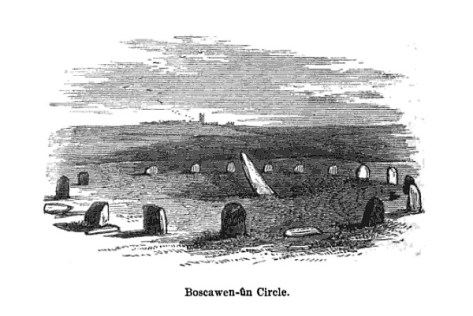
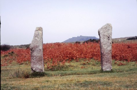
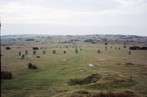
4. Boscawen-Un
In the parish of St Buryan is the stone circle of Boscawen-Un, dating to the early Bronze Age and consisting of nineteen stones there are several interesting features of the site. The most obvious is the stone which is slightly south of center, it leans sharply towards the north east and at its base there are two very faint relief carvings of axe heads. A past student once suggested to me that the stone itself looked like a large stone axehead which had been struck into the ground. Minor excavations have further revealed that its leaning position was intentional and not the result of subsidence. The second interesting feature of this stone circle is the large block of quartz to the south west which is part of the circle. Our understanding of the role of quartz within prehistoric rituals is poorly understood but there is an increasing amount of evidence which points to its importance.
Boscawen-Un is one of several archaeological sites which feature in my novels – The Adventures of Sarah Tremayne.


5. A Fogou
Okay, so now I really am cheating but the fact is any visit to Cornwall should definitly include a fogou and I couldn’t decide which I preferred – Carn Euny or Halligye are the easiest to get to and Halligye the largest (it can be found on the Trelowarren Estate, near Helston) however, Carn Euny does have a courtyard settlement, the nearby hillfort of Caer Bran and the fogou itself has a beehive shaped internal chamber. So you can see my dilemma…I have already written about fogous in an earlier blog so shall not rehash what we know and don’t know about these enigmatic structures.

6. Carn Brea
Situated between Redruth and Camborne is long hill easily visible from the A30, it is a hill with a long history beginning as far back as the Neolithic. Today two features stand out the most, firstly the the tall monument on the central summit erected in 1836 in the memory of Francis Bassett of Tehidy and the second is the small medieval castle perched on an outcrop. The latter was most likely a hunting lodge belonging to the Bassetts, an ancient local family and was first recorded in the fifteenth century. The land surrounding the hill was prime tin mining country and the flanks of the hill are covered in shafts and pits.
Heading further back in time the astute visitor might notice the remains of eleven Iron Age roundhouses on the saddle between the east and central summits, these are part of a much larger settlement on the hilltop, set within a substantial hillfort of forty-six acres. The defences are made up of two ramparts enclosing the hill. However, the occupation of Carn Brea began much earlier in the Neolithic. Surounding the eastern and central summits are another two smaller enclosures, of these the eastern summit has been partially excavated. The date range showed that the ramparts had been built somewhere between 4000 and 3500BC, making it the oldest known fortified settlement in Britain. There were traces of wooden buildings and Neolithic pottery, in addition a large number of flint arrowheads (700+) were uncovered along with evidence for the destruction of the site suggesting the site had been under attack (Cornish Archaeology, 1981, 20).


7. Trevelgue Head
So many visitors to Cornwall will invariably end up in Newquay without realising the long and fascinating history of this seaside town. Just north of St Columb Porth on the road to Watergate Bay is the impressive cliff castle of Trevegue Head. It is the most heavily defended of all the cliff castles with seven lines of defence. The first ditch and bank is not so obvious as the next six with largest bank being roughly four metres high. Erosion over the centuries has seen much of the land disappear and it is suggested this included the original entrance. Excavation in th 1930s demonstrated that Trevelgue was continously occupied from the thrid century BC until the fifth/sixth century AD. At least fourteen roundhouses were identified (it is still possible to see the house platforms with a keen eye). Given its position in the landscape, the sheer scale of the defences, some of the artefacts found (bronze horse harness and Roman coins) in addition to the significant amount of evidence for both bronze and iron smelting, it is fair to say Trevelgue Head was most likely a high status site, the home ground of someone of great import.
The importance of this headland and other similar to it along the coast is further attested to by the presence of the two bowl barrows dating to the Bronze Age – these were opened in late 1800s but nothing is known of their contents. Further along the coast is Trevelgue Downs where a further two barrows can be seen. In the eastern barrow a crouched adult skeleton was found within a stone cist with a stone battlexe close to hand. From personal experience I have walked this cliff castle many times and it was not uncommon to espy tiny Mesolithic flints protruding from the exposed edges of the paths. Further testament to the sites long history.


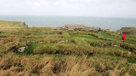
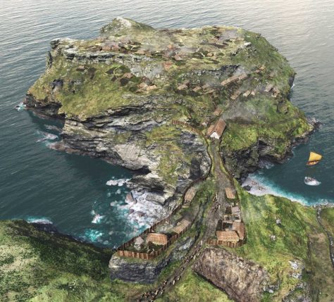
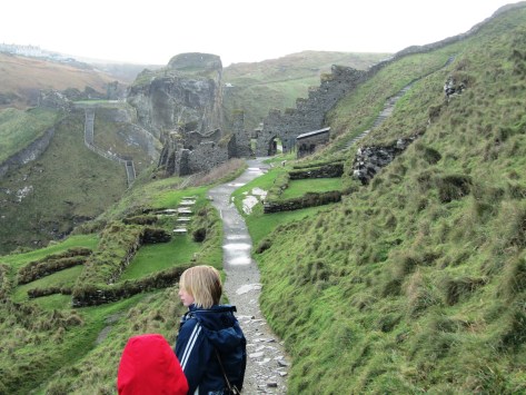
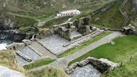
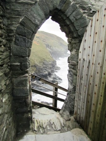
8. Tintagel
It had to be on the list – perhaps one of the most controversial of all sites in Cornwall from local resistance to English Heritage’s plans for the site to the myriad of myths and legends associated with Tintagel – no where captures the imagination more. Like several other sites on this list I have already waxed lyrical about Tintagel so will not bore the reader with much of the same (but do follow the link if you want to seperate fact from fiction).
9. Castle an Dinas
An impressive example of an Iron Age hill fort found in mid Cornwall near St Columb Major. Measuring 260m across it would have been a formidable place in its heyday, the substantial ramparts are visible for many kilometres even today. There is some faint evidence for a much earlier enclosure on this hilltop possibly dating from the Neolithic or Bronze Age and the presence of two Bronze Age barrows within the hillfort is further testament to the importance of this place throughout prehistory. In the early 1960s a relatively small excavation was undertaken with the idea of prove the tradition of such places being re-used during the post-Roman phase and although they failed to do this a fine cobbled road was found.
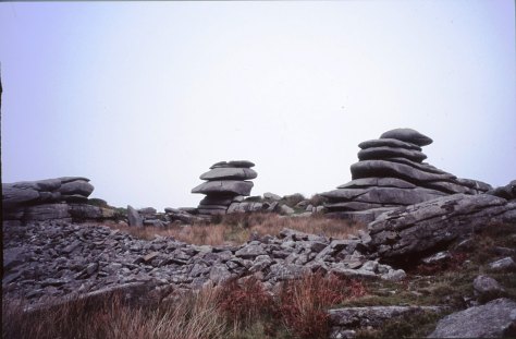
10. Bodmin Moor
Yes I know this really is cheating…but no list of sites to visit is complete with at least one from Bodmin Moor. However the problem is I could not choose just one, there are so many wonderful sites to visit on the moor. Like its much larger cousin in the next county over, Dartmoor, Bodmin Moor has a wide variety of archaeological sites to visit beginning way back into the Mesolithic (flint scatters possible representing seasonal camps as found on Butterstor) and the Neolithic such as Stowes Pound and Rough Tor which are thought to be tor enclosures similar to Carn Brea and Trencrom further to the west, but it is the Bronze Age which dominates the archaeological record.
There are stone circles, stone rows, menhirs, barrows (earthen mounds), cairns (stone mounds) and of the latter there is in excess of 300 known. The most well known barrow is the Rillaton barrow which is the largest on the moor and where an individual was buried with a bronze dagger, an urn and a beaten gold cup.
“…the distribution of the monuments throughout the whole of the upland suggests that its use had intensified enormously. Virtually every block of land (as defined for example by prominent hills and divided by rivers and streams) is marked by a group of cairns, as if all available land was claimed and accounted for. The analysis of fossil pollens fromthe ancient land surfaces sealed beneath the excavated cairns shows that by this date the upland was predominantly open grassland, with woodland confined to the steep valley sides.” (Herring P & Rose P Bodmin Moors Archaeological Heritage pp17-18)
There are sixteen known stone circles of which the best known is the Hurlers. All the circles seem to have been placed carefully within the landscape – nearly all are within sight of tor which is always to the north of the circle, with Roughtor being the most dominant (nine of the sixteen circles). The stone rows, menhirs and embanked avenues are not as numerous but still make up an important part of the ritual landscape.
A feature of the later Bronze Age landscape of the moor is represented by the vast numbers of settlements represented by field walls and the stone foundations of round houses. There are approximately 1500 prehistoric round houses representing around 200 settlements and although only three have been excavated they are assumed to be all by analogy with Dartmoor to belong in the second millenium BC. Often found associated with these settements are field systems of varying shape and size best seen from the air and on large scale maps.
Ar around 1000BC a deteriorating climate and soils resulted in most settlements being abandoned and the use of the moor being less intensive. The hillfort sites of Bury Castle, Cardinham and Berry Castle are the only easily identifiable settlements of the Iron Age, although it is assumed that the moor continued to be used for the seasonal grazing of livestock, much as parts of it are today.
Further Reading
Rowe T M (2005) Cornwall in Prehistory Tempus/History Press
Weatherhill C (2009) Cornovia Ancient Sites of Cornwall and Scilly Halsgrove
Johnson N & Rose P (2003) Cornwall’s Archaeological Heritage Twelveheads Press
Herring P & Rose P (2001) Bodmin Moor’s Archaeological Heritage Cornwall County Council