As an Amazon Associate, I earn from qualifying purchases and as such some of the links in this blog are affiliate links. This means if you clink on the link and purchase, I get a small commission, at no extra cost to you. The items I have linked are always ones that I myself have enjoyed/read – all opinions remain my own.
Books, they are my friends, they transport me into different worlds, past and present, real and imaginary. So imagine my difficulty in choosing just five to tell you about! Thus this will be the first in a short series of my top five book posts. Moving on…this particular post is centered around my favourite general books related to archaeology in the UK. Please note that the opinions in this blog are purely my own and are listed in no particular order.
1. ‘A Little History of Archaeology’ Brian Fagan
More often than not when studying archaeology at University, there is always one paper that is required – the history of archaeology. For some this can be the ‘dull as dishwater’ topic, the one you dread every week but for myself I always found it fascinating. Archaeology is such a strange discipline, it borrows from just about every other subject to become something unique, constantly evolving.
Brian Fagan’s book takes the reader on an adventure in archaeology around the world, from it’s very beginnings with antiquarians and collectors to the present day science based enquiry. There are tales of wandering antiquarians in the American Southwest at a time when Apache tribes were on the warpath to the Mesolithic finds trawled up from the North Sea. Ever wondered about how radiocarbon dating became a thing? Or why we have the ‘three age system’? The answers and more are all here.
Fagan writes in an engaging style with a hint of adventure and is more than a match for those ‘dull as dishwater’ lectures. I thoroughly enjoyed reading this book and highly recommend it to everyone interested in archaeology.
Subtitled ‘The Prehistory of Britain in Seven Burials’ Alice Roberts takes the reader on an interesting journey into the past via the dead. Regardless of our views on whether the dead should be disturbed/excavated, there are situations when this is inevitable and in this book Roberts picks apart these burials to tell the human story of British prehistory.
‘Burials are like time capsules – each one, a physical biography, written into a skeleton.’
From the back of the book
For each of the burials she chooses (which range from the paleolithic – the red lady of Paviland – to the Iron Age and the Pocklington Chariot), Roberts gives a history of the discovery of each burial as well as the research past and present that has gone into each discovery. She also widely discusses the new science of genomics and how it is changing the way we view the past in Britain.
Alice Roberts writes in chatty style, having seen her on tv many times I could easily hear her voice narrating the story in my head. Through her writing the reader gets a clear sense of her curiosity and knowledge, her willingness to explore avenues to find answers. Even when she is warning of caution she does so with friendly caution. It is up to the reader to draw their own conclusions. This is in essence why this book makes it to my top five, Alice Roberts does not lecture, she leads you along a path of discovery and allows you to come to your own conclusions.
For those interested in the megaliths that are found through the United Kingdom this is the go to book. Coming off the back of the successful website ‘The Megalithic Portal‘ this book details all the fabulous sites listed online with extra short essays on topics such as astronomy, archaeoacoustics, stone axes and more, written by users and contributors to the website. There are maps, photos and drawing galore as well as a well written introduction to the Neolithic and Bronze Age in the UK. It is the kind of book that you can dip into as and when you need to.
I would highly recommend this book to anyone who wants an adventure back through time, who has ever stood and stared at a stone circle and wondered why or for those who want to just make a walk in the countryside more interesting.
For fans of the tv show ‘Time Team’ Mick Aston will be a familiar face, his shaggy hair and stripey jumpers are things of legend, and although no longer with us his legacy in archaeology remains strong. This book is for those who want to know more about Mick, his beginnings in archaeology (in Cornwall), the reasons behind Time Team, his love of teaching, landscape archaeology and all things monastic.
I met Mick on several occasions, twice with Time Team and once at tea whilst at a friends house in Cornwall. He was a lovely man with a genuine interest in everything around him. When you talked to him he really listened and was always open to ideas, even if they didn’t necessarily align with his own.
I recommend this book for lots of reason, not only because Mick Aston is a man I admire and respect but also because of his ethos that archaeology belongs to everyone not just the academics. His belief in the importance of community archaeology permeates this book and is also an ideal I hold dear.
Victor Ambrus was another Time Team regular, his reconstruction drawings bringing the past to life in a way that was very human. Todays digital reconstructions are nice but there is always a sense of life in the hand drawn pictures by Ambrus. Many of the drawings in this book are from sites featured on Time Team but not all.
Victor Ambrus draws/paints a site and then places people in it, using the site as it may have been used, there are animals, trees, birds and more. Reminding us all that a site was not isolated, it was part of an environment both natural and human. Some of his drawings depict characters we all know from the past, such as Henry VIII or King Cnut. There are scenes of warfare, crime and punishment, prehistoric rituals, medieval feasting, Mesolithic life and many more. Each of the drawings are accompanied by a short commentary by Ambrus with the background to the picture. Throughout the book you are constantly reminded of the lives that came before. I particularly like to look out for the wee dog that always seems to be barking at something…
And there you have it…my top five books on archaeology, perhaps not the most conventional choices but they are the ones I have enjoyed reading the most and from which I have gained the most insight into what it means to be an archaeologist.
In the northern hemisphere when the weather begins to bite and the nights draw in thoughts turn to that time when it is said the veil thins between our world and that ‘otherworld’. Samhain, Halloween or All Hallows is a festival celebrated in many ways in the northern hemisphere (and in the southern hemisphere, somewhat erroneously). Previously on this blog tales have been written about witches, ghosts and the superstitions of Halloween – all of which are pretty standard topics for the time of the year.
So now lets turn our attention to the lesser known spooky stories of objects said to be haunted such as skulls that scream and drums that, well, drum…
The Rillaton Cup
The Rillaton Cup – British Museum
In 1837 a Bronze Age barrow on the eastern side of Bodmin Moor in Cornwall was excavated. Human remains were found alongside a number of objects including a bronze dagger, beads, pottery and a gold cup – the Rillaton Cup. At 90cm high, with a handle attached with rivets it resembles the beaker style of cup known from other Bronze Age burials. It is said that the cup is haunted by the spirit of a druid priest who offers travelers a drink from the undrainable cup. Local legend tells of one man who, in a fit of Christian pique, threw the contents of the cup at the ghost. He was later found dead in a ravine…
Busby’s Chair
Can a curse on chair result in the deaths of those who sit in it? In North Yorkshire there is such a tale centered around a Thomas Busby who was arrested, tried and executed for the murder of his father-in-law in 1702. Two versions of the local legend exist – one says that Busby cursed the chair on his way to the gallows and the other says he was drunk in the chair when arrested and that was when he cursed it. He was hung at a crossroads near an inn where the chair resided until the late 1970s. It was said that during the second world war Canadian airmen from the nearby base who sat in the chair never returned from their bombing missions over Europe. Following a series of fatal accidents linked to the chair in the 1970s the chair was donated to the museum at Thirsk where it hangs permanently on a wall beyond the reach of curious bottoms…
The Great Bed
In the town of Ware (Herts)there once was a carpenter named Jonas Fosbrook who made a bed fit for a king. It is massive four poster constructed from oak and measuring 3.38m long and 3.28m wide. It was said that Fosbrook intended the bed to be used for Edward IV although there is no evidence of this ever happening. The bed was owned by several of Wares inns; it was alleged that once in the 17th century twelve married couples slept in it. However, it is said that the ghost of Fosbrook will pinch and scratch anyone who slept in it because the bed was not being used for royalty. The Great Bed is now housed in the Victoria and Albert Museum in London.
The King’s Lynn Brick
In the wall of a house on the north-west corner of the ancient Tuesday market in King’s Lynn is a diamond shaped brick with a heart carved into it. According to local tradition it marks the spot where the heart of witch burst from her body as she was being burnt at the stake and hurtled across the market square to smash against the wall. Being burnt at the stake was not a common means of execution for those accused of witchcraft in England, hanging was the preferred method however one of the few witches to suffer death by fire in England was Margaret Read of King’s Lynn in 1590.
‘Alas poor Yorick…’ – Skulls and more skulls…
Keeping a skull of a long dead ancestor or past occupant of a house on shelf or in a cupboard should be a rare and somewhat odd occurrence, but it is not. A brief foray into the records shows that there are at least half a dozen instances of skulls being kept in houses across the UK.
On a farm near Buxton in Derbyshire there is a skull known affectionately as ‘Dickie’, said to have once been a Ned Dixon who was murdered by his cousin in the house – although the tale is also sometime told as love triangle where two sisters fell in love with the same man and one sister murdered the other. Either way, it is said that should the skull be moved then all kinds of disasters will fall upon the farm. A well meaning soul once thought to bury the skull and before long things began to go wrong – pigs died, cows became ill and crops failed. Once the skull was retrieved life once more settled down and all was well.
On another occasion, in 1870 there were all sorts of issues regarding unsuccessful building work by a railway company who were a little to close for comfort and disturbing ‘Dickie’s’ rest. The issues soon stopped though when the railway company chose a different route for the railway…
Burton Agnes Hall in Humberside was built by three sisters in the seventeenth century. One day the house was attacked and the youngest sister Anne was mortally wounded. Before she died she asked that her head be kept in the house she loved. Her sisters chose to ignore Anne’s request and she was buried whole in the local churchyard. However, Anne’s unhappy soul created havoc in the house and eventually the sisters were forced to disinter their sister and remove her head. Some years later a new maid took fright when she came across the skull and threw it out of a window where it landed on a passing cart. The story tells how the horse stopped immediately and would not move until the skull was returned to the house. It is now bricked up in one of the walls so it can never be removed and since then all has been quiet, even if her ghost is still occasionally seen watching over her beloved home.
Burton Agnes Hall, Yorkshire – from The County Seats of the Noblemen and Gentlemen of Great Britain and Ireland, by Francis Orpen Morris. Original held and digitised by the British Library. (source: wikimediacommons)
At the head of the staircase in Wardley Hall, Greater Manchester is the skull of Father Ambrose Barlow who was hung, drawn and quartered in 1641 when he confessed to being a Catholic priest. It is said that if moved it emits blood curdling screams and will bring misfortune on the house. The antiquary Thomas Barritt wrote of the skull, “if removed or ill-used, some uncommon noise and disturbance always follows, to the terror of the whole house.” When Wardley Hall was divided into miners tenements, the new tenants attempted to rid themselves of the macabre object much to their detriment. Peace was only restored once the skull was brought back to the Hall.
Near to the shore of Lake Windermere is the sixteenth century manor house called Calgarth Hall. Before the manor was built the land it sits upon was farmed by Kraster and Dorothy Cook who refused to sell their land to the neighbouring landowner and magistrate Myles Phillipson which led to a great deal of ill feeling between the two parties. However as Christmas approached Phillipson invited the couple to dinner declaring he wished to mend the rift. The Cooks were happy to obliged and duly arrived at the magistrates house on Christmas morning, unfortunately the day did not end well when it was found that a small silver bowl which had been on the table near Kraster had gone missing. The Cooks had just put on their coats which had been unattended all day and when searched the bowl was found in Kraster’s pocket.
The Cooks were arrested, tried and found guilty of theft – all before the magistrate, Myles Phillipson. As was the law in those days they were sentenced to hang, as Dorothy was being taken from the court she cried;
“Guard thyself, Myles Phillipson! Thou thinkest thou hast managed grandly but that tiny lump of land is the dearest a Phillipson has bought or stolen for you will never prosper, neither will your breed…Never will you be rid of us”
The following Christmas the hall had been built and was ready for occupation and a huge banquet was planned. The evening of the banquet the lady of the house went upstairs and to her horror came face to face with two skulls grinning at them from the balustrade, one even had hair much like Dorothy’s. The guests declared this to be some nasty prank and threw them into the yard, later that night the skulls reappeared. After which all attempts to get rid of the skulls failed, as time and time again they reappeared on their perch. Myles Phillipson suffered multiple misfortunes and with each setback the skulls would scream in celebration. On his death he had lost all his lands, wealth and positions. The hall was inherited by his son and the skulls only appeared at Christmas, but Dorothy’s curse continued and the Phillipson family became impoverished. Only when the hall passed into new hands did the haunting of Calgarth hall cease.
At Higher Chilton Farm at Chilton Cantello, Somerset there is a special cupboard containing the skull of Theophilus Brome, a one time owner of the farm. Theophilus died in August 1670 and one of his last requests was to have his head removed from his body and kept at the farm for all of time. The reasons for such a strange request are unknown and it is not known if he had placed a curse on any who would remove his skull from the farm. But what is told that whenever someone has attempted to move the skull the resulting supernatural commotion has meant it remains in the house. In Collinson’s History of Somerset from the 1860s there is an entry which refers to the skull.
“…(of which) the tenants of the house have often endeavoured to commit to the bowels of the earth, but have as often been deterred by the horrid noises portentive of sad displeasure…”
In Dorset at Bettiscombe Manor another skull can found which objects strongly to being moved from its abode. One nineteenth century tenant of the manor had the audacity to throw the skull into a pond. The house was shaken by screams and tremors for days until the skull was retrieved and placed back in the house. Interestingly, analysis of the skull has shown that the skull is about 2000 years old and is that of a woman in her twenties.
Country below Bettiscombe Manor. Fields on either side of the valley lead towards Bettiscombe Manor, home of a screaming skull. (Derek Harper / Country below Bettiscombe Manor / CC BY-SA 2.0)
Read more about England’s screaming skulls here and here.
Drake’s Drum
In Buckland Abbey, Devon is Drake’s Drum, said to have accompanied Francis Drake when he circumnavigated the globe in 1577-80. Not unlike the legend surrounding King Arthur it is said that Francis Drake is not dead but only sleeping. Whilst not necessarily haunted it is said that if his drum is beaten he will wake to his country’s call. The drum is said to have been heard when the German fleet surrendered in 1918.
Replica of Drake’s Drum from the education center at Buckland Abbey (source – wikimediacommons).
There are many objects from around the world which are said to be haunted or cursed, some are famed and others not so much – Ebay apparently do a roaring trade in haunted items…be ware the buyer…
If you want to disappear down a rabbit hole then these sites are a good place to start – happy haunting…sorry I meant hunting…
People have always lived in the area that is now known as London, a visit to the London Museum will tell all you need to know about London before it was London. However, it was the Romans who gave the area its name – Londinium – and apart from a small hiccup in the first century AD they provided the structure that would become one of the most famous cities in the world.
Although later parts of the cities history can be easier to spot, the evidence for Roman London is possible to find. The following is not an exhaustive guide, just a few pictures and the like of places as and when they were found.
The most obvious evidence for the Romans can be found in the bits of surviving wall that once surrounded the town. Short sections of the wall survive in various places (one section is in an underground carpark) and are really the only upstanding remains left – all else having been destroyed and built over by later generations. The wall remained (with later additions and repairs) because it was useful. For those wishing to walk the wall – follow the road ‘London Wall’ which leads to and from the Museum of London, along the way are several signposted places of interest.
The above photos show a section of the wall at Tower Hill (first three pictures) and one of the bastions and wall section of the Cripplegate fort. The Roman fort formed part of the wall defences when it was built in the second century AD. Follow this link for an interactive map of other locations of the wall sections. Do keep in mind though that the Roman parts of the London wall are generally speaking the lower sections, later Londoners did alter, reinforce and reconstruct much of the upper sections as and when was necessary.
As mentioned before an essential place to start if you want to know more of London’s history is with the London Museum. More so if you want to learn about the Roman period and earlier as much of the evidence comes from excavations. The Roman galleries paint a fascinating picture of life at the time with the added bonus of a section of the Roman wall being just outside the museum (see above photo).
Part of the gallery is laid out as a series of ‘rooms’ where objects are given life like context. For example, cooking pots and utensils are placed within the context of kitchen befitting a Roman home.
There are also many of the usual museum type exhibits. It was particularly interesting to see the exhibit on the burial of the Roman woman found at Spitalfields.
The above photos show a reconstruction of the Spitalfields woman may have looked like. Roman London was a cosmopolitan city and by AD120 the population was around 45,000. Many of the people living in Londinium came from all over the known world. The Spitalfields lady’s burial was of high status, not only did she have a stone sarcophagus but also a highly decorated lead coffin (above). Fragile glass vials were found with her as were pieces of Damascus silk. Chemical analysis indicated that she was one of the few known people to have actually come from Rome. Read here for more of her story.
Every generation since London’s inception has reimagined the city, demolishing that which did not fit or was not useful and rebuilding for their own purposes. Resulting in thick layers of history beneath the roads and buildings we see today. Every time a new road, building or train line is built the archaeologists move in to hastily uncover what can be seen, such as during the Cross Rail project. Many of these reports can be accessed via the Archaeological Data Service along with others such as 1 Poultry Lane and Tower Hamlets excavations.
Most of what is excavated does not survive the process for numerous reasons, however in one case the remains of Roman temple has been preserved deep underground – the London Mithraeum. Located beneath Bloombergs European headquarters in the heart of the city is the well preserved and intriguing site of a temple dedicated to the eastern god Mithras.
The mysterious cult of Mithras first appeared in Rome in the 1st century AD. It spread across the Empire over the next 300 years, predominantly attracting merchants, soldiers and imperial administrators. Meeting in temples which were often constructed below ground, these were private, dark and windowless spaces. (From londonmithraeum.com).
The temple was built in the third century AD and it lies on reclaimed land over what was once the river Walbrook; because of this a number of wooden artefacts survived. After the 1954 excavations the site was physically moved and reconstructed in the 1960s on the far side of the plaza from where it sits now. During the construction of the Bloomberg center even more excavations were undertaken revealing even more about the sites fascinating past. As part of this process, it was decided to move the mithraeum back to (as close as possible) to its original position seven meters below modern ground level and open it to the public as educational and exciting place to learn about Roman London.
The experience is immersive – the visitor stands in a darkened room, surrounded by the sounds of the temple as it may have been, judicious use of lighting draws your attention to various spaces. Each session is timed and numbers limited (booking is essential but free). This allows for an unhurried and unharried visit of the mithraeum – evoking an atmosphere of quiet contemplation, similar to that felt when visiting a church.
Although there is a small display of some of the many artefacts found during the 1954 excavations the sculpture featuring Mithras and the bull can be seen at the London Museum.
Another feature of Roman London which can still be traced above ground, so to speak, is that of the roads which ran in and out of the city. Some of the names may be familiar – Ermine St (now the A10/Kingsland Rd), Watling St (of which there are two…), not always easy to see or follow, later changes to the topography can blur the picture but it is always lovely when you accidentally find one such road…
Here is the Watling Street which most likely ran south east past the mithraeum and across London Bridge heading towards Durovernum (Canterbury) and the coast. The site of todays London Bridge is roughly in the same position of the first proper bridge across the Thames built by the Romans.
Unlike later periods of London’s history the Roman story can be a little harder to find however it is well worth the effort should you make the attempt.
A view from the Roman villa back into the Iron Age.
Experimental archaeology is the one path that virtually anyone can take to travel back in time; to get an idea of what life may have been like in the distant past. One such place which encapsulates this philosophy is Butser Ancient Farm, a place I had the chance to visit recently.
Butser began life in 1972, in a different location by the late Peter Reynolds, whose passion for experimental archaeology was contagious. The original farm was situated on Butser Hill, in what is now the Queen Elizabeth Country Park, in part because of the evidence for extensive Iron Age field systems on Butser Hill, still visible in the prehistoric field boundaries and earthworks that cover the landscape. However, it did not open to the public until 1974 and because of its popularity moved to a more accessible site at the bottom of Butser Hill. In 1991 the farm moved to its present location (near Chalton, Hampshire – just off the A3).
At Butser it is possible to see ten thousand years of history come to life; to see plans of archaeological sites rise up from the ground; to feel, touch, smell and absorb some of what it may have been like in the past is an experience that should not be missed. All of the buildings which have been reconstructed are based on actual archaeological sites that have been discovered through excavation.
These excavations often only reveal the faintest of remains, the postholes and their layout is usually all archaeologists have to go on as to the type of building. The artefacts found and their position in the structure can also provide clues as to the use of the space inside and outside. Understanding all the fragmentary pieces of evidence can often take a leap of faith particularly for the general public. In this case Butser provides a physical and tangible connection to the past for the visitor.
However, it is much more than that, it is a place where those who study the past can test theories in, not only ancient technologies and construction techniques but also in how sites degrade. Our understanding of how archaeological sites are formed depend very much on understanding how a place degrades, becoming the humps and bumps we see in the landscape.
In addition to the buildings, there are also gardens containing plants that would have been in use at a particular time – known from faunal analysis during excavations. Ancient breeds of sheep, goat and pig are also a feature of the farm, giving the visitor a well-rounded experience. At certain times of the year, they also host various events such as flint knapping weekends, re-enactment groups, storytelling, solstice celebrations and more.
The following are few photos from my visit this year…beginning in the very distant past of the Mesolithic and Neolithic.
In the days preceding my visit the team at Butser along with volunteers from the HMS Queen Elizabeth had a go at erecting a megalith using only the types of technology available in the Neolithic. They moved and raised a 3.5 ton piece of Purbeck limestone using theorised prehistoric techniques. The stone is roughly the same weight as the smaller bluestones at Stonehenge, which were moved over 140 miles around 5000 years ago.
When performing such tasks it is also useful to observe what is left behind, these ephemeral remains are often the hardest to interpret.
A wooden raft used to move the stone across the land.part of the frame used to raise the stone.And it’s up!
From the Neolithic we carefully saunter into the Bronze Age, the time of the roundhouse and metal working…
In the majority of cases the only evidence we have for roundhouses are the postholes left in the ground. What is less well understood is what were the walls and roofs made of and how. At Butser they have constructed the Bronze Age roundhouse using several different methods of wall construction.
The Iron Age –
The Roman villa – as with all the structures at Butser the villa was built using only construction techniques known to be used in the Romano-British period. The mosaic is the only known reconstruction in the UK and the aim was to understand some of the finer points in mosaic construction but also to see what happens to it over time.
The loo…
The Anglo-Saxon halls are the most recent addition to the farm and demonstrate two different types of building style.
As mentioned before Butser also engages in research and education, none of the buildings, gardens or spaces are static museum pieces, they are constantly evolving – adding to our knowledge. Most years the farm is well attended by schools wide and far who get a hands on perspective of life in the past, archaeology and history.
A building dedicated to hot technologies under construction – a dedicated space for smelting, metal casting, pottery firing, bead making etc.
In several places around the farm are these curious structures. Used for school visits they give the children hands on experience at excavation and archaeological practices.
The archaeology of decay…
The gardens and the animals are an equally fascinating aspect to the farm, endeavoring to give a much more rounded picture of the past.
For more information I would highly recommend their website (and archive) – Butser Ancient Farm
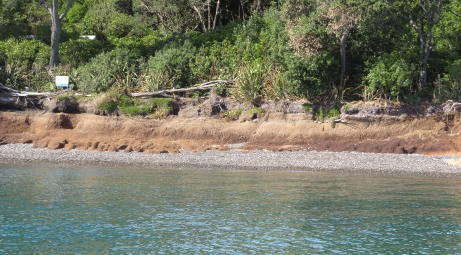
Auckland was recently subjected to what the meteorologists refer to as a ‘weather event’. High winds and a months worth of rainfall caused damage and chaos throughout the city. None more so than on the islands of the Hauraki Gulf including Otata.
Reports came in of erosion and the lost of the shingle beach exposing the clay beds. It was decided that a visit to the island would be necessary, to assess and record the damage to the midden site. In addition, Louise Furey, the archaeology curator at the Auckland Museum, invited Bruce Hayward and Robert Brassey for a second opinion on the stratigraphy of the site (the former a geologist and the latter an archaeologist who had worked on the nearby islands of Motatapu and Tiritiri Matangi).
The first attempt to visit the island was thwarted, yet again by bad weather. However, on the second attempt we were graced with a stunning day with tides and winds in our favour and so we set off early morning. It was with some luck that only a few days earlier, the wind and tide redeposited much of the shingle back onto the beach, making landing on the island a little safer. On our arrival we could see that the sea had not been kind to the midden and much of the beach had indeed been washed away, leaving the midden sitting up high.
We spent the day measuring levels, recording and describing what could be seen. An Auckland Museum photography was on site to provide a photographic record of the midden in detail (look out for the video during Archaeology Week 2022). There was also a great deal of discussion regarding the stratigraphy – the outcomes of which can wait until the published report.
The following photos are of the site as it was seen on March 28th 2022 – these photos are my own.
Main Beach from the boat – the grey band is the remaining shingle, the dark brown band is the clay and above that are the midden layers.
The area of last years excavation – where the cobbles and branch is sticking out of the edge is where I excavated last year. The base of this square was at ankle height but is now almost chest height.
Taking levels.
For more information see a previous article on Otata here or visit the Noises website here and here for articles by Emma Ash (Assistant Archaeology Curator, Auckland Museum).
Coastal sites are always at the mercy of the environment and it can be heartbreaking to watch them year after year become less and less. The greatest shame is in the loss of the information that would have been gained if time and funds had allowed. Yes, it is true that excavation is destruction but when a site is under threat from elsewhere then surely it is time to step in and save that information for future generations. This is often done in urban areas before large developments are undertaken. Rescue archaeology shouldn’t just be about pre-development but also about the natural damage being done to archaeological sites.
Recently I was contacted by a reader of this blog who showed me a small but intriguing artefact he had found on the beach at Fitzpatrick’s Bay (Waitemata Harbour, Auckland, New Zealand). The photo was of a single piece of clay pipe stem, not all that unusual in itself. Clay pipes are one of the most common finds on any settler/colonial sites. However it was the legend stamped onto the opposing sides of the stem that caught my attention – ‘SQUATTERS BUDGEREE!!’ – yes there are two exclamation marks at the end of the legend.
Such an unusual name must have a good story…
A quick online search located an article published in the Australian Historical Archaeology journal which was able to provide the background to the name (see below for the reference to the article and link) and some eloquent discussion on the symbolism associated with this particular pipe.
This particular type of clay tobacco pipe was manufactured between 1840 and 1865 for the Australian market and was one of the ‘first commercial products specifically branded to appeal to the Australian colonial market’. It should be noted that these were most likely manufactured in the UK and not actually in Australia. Although Gojak and Courtney (2018) suggest that the mold was created by someone with local knowledge. When first manufactured the pipe itself spoke volumes about the political and social situation in Australia at the time.
Australia in the late 1830s and 1840s was undergoing a period of pastoral expansion which resulted in the dispossession and often violence towards indigenous people. Events came to a head with the Myall Creek massacre in 1838, here around thirty Indigenous people were murdered. This went against the then colonial government who tried to reign in the pastoralists and protect the Indigenous people. The government hunted down a number of those who were responsible for the massacre, seven of which were executed.
The symbolism therefore advocated for the pastoral interests at a time when there was a significant divide in colonial society…the symbolism of the pipe matched what many people already believed, that Aboriginal society was widely thought to be doomed…reflecting the belief in the inevitability of the strong and advanced overcoming the weak and primitive.
Gojak, D., & Courtney, K. (2018). Squatters Budgeree: a distinctive clay tobacco pipe produced for the Australian colonial market. Australasian Historical Archaeology, 36, 5–15
The bowl was decorated with coarse depictions of Indigenous people drinking alcohol on the side with word ‘budgeree!!’ And a pastoralist with animals under a cabbage tree on the side with the word ‘squatter’. The symbolism of the two opposing scenes clearly spoke to many in colonial Australia of the differences between the Aboriginal world of chaos and savagery and the world of the pastoralist – serene, productive, sobriety and quiet reflection. Even the exclamation marks at the end of the legend serve to emphasise the indignation of the pastoralists who felt they were being unfairly treated by the government in favour of the Indigenous people.
Unfortunately, all that was found at Fitzpatricks was a short fragment of stem but the words stamped on the stem are also a political statement. Both words originate in New South Wales – ‘squatter’ refers to the pastoralists who grazed their herds on land without government sanction, whilst ‘budgeree’ is a form of pidgin local dialect and comes from the Dharug language from Sydney. It means ‘something that is good’ or ‘someone who is doing well’. Thus the words can be read that the ‘pastoralists are doing really well’.
From this point on colonial society became split into two camps, those who supported the pastoralists and those who did not. Using the ‘Squatters Budgeree’ pipe became a political act – a way of displaying support for the pastoralists. Not dissimilar to our modern inclination of showing support for various causes on a t-shirt.
Photo by D J Payne and used with permission.
Photo by D J Payne and used with permission.
So, what is an Australian tobacco pipe doing in New Zealand? Other Squatter Budgeree pipes have occasionally turned up during excavations in New Zealand, such as, at Paremata on the Porirua Harbour and the Victoria Hotel site in Auckland. In the case of Paremata, a military site, it could be that it arrived as a personal item with troops from Australia at the time of the New Zealand wars. Whilst the excavation of the Victoria Hotel yielded a large number of clay pipes, amongst which was a variety of Australian themed types, including the Squatters Budgeree. At the time almost all of New Zealand’s imports came through Australia and it is most likely that these pipes were part of a general lot. It is equally possible that such pipes were sold in New Zealand from a job lot, so to speak, when the Squatter pipes went out of fashion after 1860.
In regard to our small but perfect specimen, the jury is out but given the bay’s proximity to the new settlement of Auckland, the connection to the harbour and of course our understanding of the early settlement of Fitzpatricks Bay – the reader can make their own judgements…
Reference – ‘Squatters Budgeree: a distinctive clay tobacco pipe produced for the Australian colonial market.’ By Denis Gojak and Kris Courtney. Australian Historical Archaeology Vol 36 2018 pp5-15.
Written with special thanks to D J Payne who brought the pipe stem to my attention and provided the photos for this blog post. Please do not use the photos without permission.
Te Wiki o Te Reo Māori – Placenames in the Landscape.
Last week it was Te Wiki o Te Reo Māori – Māori Language Week and even if this post is a little late, it seemed a good idea to take a look at the names Māori gave to their places as a way of celebrating the language of New Zealand’s first people.
As you may already know as a landscape archaeologist I have a fondness for place names (see an earlier post on Cornish Place names) so felt it was about time I had a look at place names here in Aotearoa (New Zealand).
Place names in today’s Aotearoa are either of European origin or Māori, however it should be remembered that many of the places which today have a European name did indeed have a Māori name prior. As mentioned above the purposes of this blog it is the Māori names which are of interest. The European names will be considered in a separate article at a later date.
The need to give a place a name is universal to people across the world, it is our way of defining who we are and our relationship with the world surrounding us. The names of places can commemorate an event, define a landscape feature, be used to help travellers find their way, as a warning or as a way to signify a place of importance. In regard to Māori place names difficulties arise when trying to give a literal translation into English, for some words there are more than one meaning (as it is with English). Often the meanings behind a word are not easily definable. Words such a Mana and Tapu can be given an English interpretation but in actuality have a much more complex meaning to Māori. Add to this the fact that when Māori words were first written down by Europeans often the words were misheard and misspelt – a wrongly placed vowel can change the meaning of a word quite drastically.
What follows is just a few of the many place names and their interpretations.
One of the most important common words that make up Māori place names relate to features in the environment. Thus a word that begins with ‘Awa’ could refer to a river, gulley or valley; ‘Manga’ though is a stream or tributary and is not to be confused with ‘Maunga’ or mountain. The prefixes can be followed by other descriptive terms such as, iti/small, nui/big, roa/long. They can also have the names of people attached to them, the names of gods and the names of birds, fish and fruit. The latter often indicating the good places to forage for the said kai (food). From the perspective of the landscape archaeologist (or anyone interested in the past) the interpretation of place names can give us clues to the past, fleshing out the otherwise dry facts with the human story.
One of the most important part of any society is the ability to feed the people. As a result there are many place names which indicate the places that are good for food gathering and growing.
Awatuna – eel (tuna) creek (awa).
Kaipataki – to eat (kai) flounder (pataki).
Kaipara – to eat (kai) fernroot (para).
Motukanae – mullet (kanae) island (motu).
Whenuapai – good (pai) land (whenua).
Motukina – island (motu) of kina (a type of sea urchin).
Otamahua – the place where (o) children (tama – short for tamariki) at seagull eggs (hua).
Kaikoura – to eat (kai) crayfish (koura) – its full name is Te Ahi-Kai-koura-a-Tama-ki-te-rangi or where Tama the great traveller stayed and lit a fire to cook crayfish. A place where even today crayfish are sought after.
Arowhenua – there are several possible interpretations of this name – good or desirable land; turning land for cultivation or to desire land.
Hakapupu – estuary of shellfish.
Ororoa – the place of roroa (a type of shellfish).
Tahekeaua – a place to catch herrings by the waterfall – taheke (waterfall) aua (herring).
Mararua – two (rua) plantations/places of cultivation (mara)
Kaikoura 1983 from Archives New Zealand.
Other resources also appear in place names:
Motukauatiti/Motukauatirahi – two bays (Corsair and Cass Bay) noted for the Kaikomako trees, the timber of which was good for firemaking.
Omata – the place of flint/quartz – O meaning ‘the place of’ and mata can mean either flint, quartz, sometimes obsidian but also headland (interpretations can depend on what comes before or after the word).
Otemata – the place of good flint or quartz.
Ratanui – plenty (nui) of rata trees.
Kaitieke – to eat the tieke (saddle-back, a native bird).
Whangamata – obsidian/flint/quartz (mata) harbour (whanga) – obsidian is the most likely candidate as it washes upon the beach here from nearby Mayor Island.
Anatoki – cave of the adze.
From Buller’s ‘A History of the Birds of New Zealand, 2nd edition’ 1888.
Then there are the names that serve to aid those navigating the landscape:
Putarepo – the place at the end of the swamp where it could be crossed.
Puhoi – refers to the slow tidal flow thus it was necessary to wait for high tide for the river to be navigable.
Otira – the place of travellers – indicating an old campsite on the Otira River where food was prepared for the trip through the Hurunui Pass.
Motuara – island (motu) path (ara) – most likely to mean an island in the path of canoes.
Tauranga – resting place/safe anchorage for canoes.
Kaiwaka – literally to eat (kai) canoes (waka) – may refer to the places where the swift flowing river has the ability to destroy a canoe.
Mangawhata – the stream by the storehouse.
Arapuni – two possible interpretations – a path to a camp or a path that has been blocked – Ara meaning path.
Whangaruru – a sheltered (ruru) harbour (whanga).
There are also names that serve to warn people away from place:
Kaitoke – to eat (kai) toke (worms) – indicating a place of poor soil.
Mangakino – bad/useless (kino) stream (manga).
Waikino – bad (kino) water (wai).
Mangamate – stream (manga) of death (mate) – one wonders what happened here to warrant such a name.
Otepopo – literally the place of the decay – or the place of Te Popo.
Motutapu – sacred/forbidden (tapu) island (motu) – possible a name given after the eruptions of Rangitoto and the island was covered in volcanic ash.
Matatapu – sacred headland.
The two islands of Rangitoto (on the left) and Motatapu (right).
Other places are simply descriptive:
Maunganui – big (nui) mountain (maunga)
Tauranga-Kohu – kohu means mist/fog and thus this name could indicate a place where the mists linger.
Waihapa – crooked (hapa) water/stream (wai).
Waihaha – noisy (haha) water/stream (wai).
Pukekahu – hill (puke) of hawks (kahu).
Pakowhai – village/settlement (pa) by the kowhai (native flowering tree).
Mahoenui – the place of many mahoe trees.
Ngaroto – the lakes.
Rotoma – the lake of clear waters.
Ngapuna – the springs
Onehunga – the place of burial
A simple perusal of any map will show that certain prefixes are more common than others and for obvious reasons. Hills (puke), mountains (maunga) rivers (awa), streams (manga), lakes (roto), caves (rua), water (wai) and harbours (whanga) are prolific features of the landscape.
Other names are used to commemorate an event thus Ahuahu (Great Mercury Island) is literally translated as ‘to heap up’ but refers to when Paikea came to the island on the back of a whale, when he landed he was cold and so heaped the warm sand over himself hence the name.
Iwikatea (Balclutha) is a reference to a great battle that occurred here and where the bones of the slain remained for many years.
The Hokianga proper name is Hokianga-nui- a-Kupe or the ‘Great returning place of Kupe’ – it is from here that Kupe returned to Hawaikii.
A panoramic view of the entrance to the Hokianga Harbour- photo by Andyking50 on wikicommons.
Patumahoe literally translates as a weapon made of mahoe, a native tree. But further digging finds a tale of how ‘in a battle at this place a chief was killed with a mahoe stake’.
Tamaki-Makau-Rau (Auckland) is called thus because of its excellent soils and bountiful harbour there were often many fights to establish who would hold this prize – literally it is translated as ‘Tamaki of a hundred lovers’ – tamaki can be translated as battle.
Motu-toa can be translated as the island where warriors fought.
Rotoiti – the full name of this lake is Te Roto-iti-kite-a-Ihenga and is interpreted as the little lake that was discovered by Ihenga.
Te Tawa – here Ihenga pushed his canoe with a piece of tawa wood, it stuck in the ground and he left it there thus naming the place after it. Ihenga features in many of the interpretations of Aoteoroa’s places.
Kirikau – a place where a battle was fought in which the contestants were naked – kiri (skin) kau (bare).
Another grouping of place names relate to the cosmological – the deities, the supernatural and the movement of the sun, moon and stars.
Tapuaenuku – the footsteps of the rainbow god.
Te Puka-A-Maui – the anchor stone of Maui (Stewart Island).
Ruataniwha – literally, the two taniwha (see earlier article on taniwha for more information) – in this case that there were two great taniwha who lived in a lake and fought over a boy who fell in. Their struggles formed the Tukituki and Waipawa Rivers.
Oamaru – the place of the god Maru.
Anakiwa – Cave of Kiwa – Kiwa was a man’s name but was also one of the gods of the sea.
Omaui – the place of Maui.
Oue – the moon on the fourth night.
Otane – the moon on the twenty-seventh night – the place of the moon.
Momorangi – offspring of Rangi (the sky god).
Te Waka-A-Maui – an old name for the South Island – referring to the canoe (waka) from which Maui fished up the North Island.
Otamarau – the place of Tamarau – a spirit who comes in the whirlwinds.
Map of Te Waka-A-Maui (The South Island)
These are all just a few examples of the wide variety of names used by Māori, there are many more that have not been touched on in this article – to do so would be the work of whole of book. Place names not mentioned are those commemorating a particular person. Ihenga and Kupe have already been mentioned but there are many others such as Mangaotaki (the stream of Taki) or Hekura, the name of a woman from the Arai-te-uru canoe. Or Ohinemutu, the place of the young woman who was killed – she was the daughter of Ihenga who placed a memorial stone at the place of her death calling it Ohinemutu. There are also the places that were named after the arrival of the Europeans such as Hiona, the name given to a pa on the Whanganui River, by the missionaries – it is the Māori name for Zion. Or Maheno, an island – the name was given by the Europeans.
Then there are the names which are very old and come from the homeland of the first people to set foot in Aotearoa. Names such as, Maketu or Nuhaka, both names are after a place in Hawaikii. Then there is Atiu, one of the oldest names in Marlborough and is a possibly a name transferred from the Cook Islands.
As mentioned before this is but a small insight of the fascinating world of Te Reo and the place names of Aotearoa. From a landscape archaeologist point of view all of these names give an insight to how Māori viewed their world and the events that shaped their memories of places. Giving us key glimpses into the past. Putting flesh on the bones of the evidence.
The British countryside is littered with the enigmatic remnants of its ancient past, there are somewhere in the region of ten thousand pre-Roman standing monuments. Modern archaeological techniques and science may be helping us to understand such sites today but once upon a time the people who lived with them found other ways to explain their redoubtable presence. Dating back thousands of years, monuments such as stone circles, standing stones, burial mounds (round and long barrows), stone rows and other such megalithic remains, provide a wealth of folklore as answers to the how, why and who questions of the past.
There are many tales to be told but the following is simply a selection of some well known and some not so well known.
One of the most well-known megalithic sites in Britain is that of Stonehenge with its own fair share of fantastical tales attached. In the 12th century Stonehenge was referred to as the ‘Hanging Stones’ because they appeared to float in the air. Geoffrey of Monmouth writing in the same century declared that Merlin (of Arthurian fame) was responsible for the building of the stones, something which was taken as fact for many centuries.
In Geoffrey’s account the king Aurelius Ambrosius told Merlin he wanted to raise a monument for his nobles who had been killed at Amesbury by the Saxon invader Hengist. Merlin tells the king to fetch a circle of stones in Ireland called the Dance of Giants that had healing properties. Aurelius went to Ireland with an army and fought the local Irish who did not want to give up the Dance of Giants eventually winning. On seeing the size of the stones, they found it impossible to move them, but Merlin was at hand who with the use of ‘his own engines, laid the stones down so lightly as none would believe’.
Of course, we know through scientific endeavor that the largest stones come from nearby Marlborough Downs and the smaller blue stones are from the mountains in Wales, not Ireland. However, it is interesting that there did still seem to be some knowledge, a folk memory, that a part of Stonehenge came from far enough away to be a wonder. It is also of interest that these stones were believed to have healing qualities, as new theories suggest that there was strong connection between healing and the presence of the blue stones in the early phases of construction. Indeed, Geoffrey of Monmouth wrote that they washed the stones and poured the water into baths ‘whereby those who were sick were cured’.
The healing power of certain stones is an enduring feature of the tales associated with them. The most well known is that of Men-an-Tol in West Cornwall, here there is a round upright stone with a hole in it situated between two small uprights. Children were passed through the hole as a cure for rickets; it was also believed to be good for a ‘crick in the neck’ and was sometimes referred to as the Crick Stone – having personally struggled through the aforementioned holed stone, it can be suggested that it causes the ‘crick in the neck’ rather than cures. At Horton in North Somerset there is a similar stone known as the Crick Stone.
Men an Tol, West Cornwall.
In Scotland, at the chamber tomb of Carraig an Talaidh, the portal stone is known as the Toothie Stane as a result of local people who were suffering from toothache would drive a nail into the stone. The idea being that in causing pain to the stone their own would cease. At the Rollright Stones it is said that they confer fertility upon women who touch them with their bare breasts at midnight. In addition, they are offer the power of prayer for the sick a boost if the prayers are said at the center of the Kings Men (the stone circle). The Kings Stone has a peculiar kink as result of the practice of chipping off pieces as good luck charms and amulets against the devil.
One of the most enduring tales associated with stone circles and standing stones is that of dancing. The Merry Maidens, a stone circle near St Buryan in West Cornwall, is said to be a circle of young girls who were turned to stone for dancing on the Sabbath. In field nearby are several standing stones known as the Blind Fiddler and the Pipers who were playing music for the dancers and when they saw their fate, they tried run but God struck them down turning them into stone. A similar tale is told of the Nine Maidens, also in Cornwall.
The Merry Maidens, West Cornwall.
A common theme in the folklore of standing stones is of people who broke the Sabbath being punished by being turned to stone, something which would have been encouraged by the Church at the time. The stones represented the pagan and ungodly past, any idolatry of such places was to be discouraged. A classic example of the pagan vs the Christian can be seen in the story of Long Meg and Her Daughters, a stone circle in Cumbria. It was the wizard Michael Scott who when passing the place saw it was a witches sabbath and turned the participants into stone – the use of magic in this instance would appear to not sit comfortably alongside Christian beliefs but then if it is used to do God’s work.
In some cases, Christianity has taken an active role in the creation of the folktales surrounding sites. For example, the Long Stone near St Austell in Cornwall is said to once have been the staff and hat of the Saint Austell. The tale states that the saint was one day walking over the downs when his hat was blown off by a sudden violent gust of wind, he thrust his staff into the ground and chased after it. Unfortunately, the violent wind turned into an equally violent storm, driving the saint back to his home without both his staff and his hat. On returning the next day to retrieve his hat and staff he found that the Devil had turned them into stone.
The Devil also features in a legend regarding the Rudston in Yorkshire, this huge monolith stands tall in the local churchyard and the story says that the Devil was up to his usual tricks of throwing stones at Christian places. Picking up a large stone he hurled it at Rudston church, but his aim was lousy, and he missed. The Devil’s Arrows near Boroughbridge consists of three stones and is all that remains of what would have been a very impressive stone row. Legend says that these stones were bolts thrown by an irate Devil aiming for the town at Aldborough and as we have already established his aim was lousy…
An example wrong doer being turned to stone comes from Gwynedd in Wales. The Carreg Y Lleidr stone is said to be a thief who stole some books from a neighboring church and was turned to stone along with the sack of books slung over his shoulder. Here folklore is being used to deter would be thieves and encourage moral behavior.
The connection between dancing and standing stones can also be seen in the notion that at certain times of the year certain stones are reanimated. Thus, Wrington’s Waterstone comes to life and dances on Midsummer’s Day but only when it coincides with a full moon. The previously mentioned Nine Maidens are said to sometimes dance at noon. On Orkney the Yetnasteen, a standing stone in Rousay, comes to life on New Year’s morning when it goes to the Loch of Scockness for a drink. Whilst at the Rollright Stones, the Kings Men are said to resume their human form on occasion, hold hands and dance to a nearby spring to drink.
The Rollright Stones (Oxfordshire) have their own creation myth associated with witches and magic. The name itself refers to a group of megalithic structures which includes a circle of seventy-seven stones called the King’s Men, a trio of standing stones which lean together and are called the Whispering Knights and a single standing stone called the King Stone. The legend first recorded in 1586 in Camden’s Britannia tells of how a king was once heading off in an expedition to become the High King of England. When he and his men reached the site where the stones are today, the owner of the land, a formidable witch appeared and told the king:
Determined to do just that, he strode forth but as he took his final step a large hillock appeared magically, hiding Long Compton from view. The witch then said:
‘Rise up, stick, and stand still stone,
For King of England thou shalt be none,
Thou and thy men hoar stone shall be
And I myself and elder tree’
Thus, the King and his men were turned to stone and between them up sprouted an elder tree.
Although the elder tree is no longer present, its inclusion in the tale is significant as it represents the pagan aspects of the site. Elder trees were regarded as the most sacred of trees and there are many superstitions and folklore associated with them. The Whispering Knights are said to either be knights who were plotting against the king or praying for him depending on who you talk to. A local legend tells of women who question the stones, leaning in close to receive their wisdom. The King Stone was known as the meeting place of Long Compton’s witches but was also believed to mark one of the entrances to the fairy halls under the circle.
The Rollright stones also have a connection with King Arthur; the tale of King Arthur finishes with him and his knights lying in an underground chamber waiting for time when Britain is in great need. Where this is exactly is of course left to the imagination but for Oxfordshire locals the chamber is located beneath the Rollrights. There are many sites around Britain which attest some connection with the legend of King Arthur, far too many to go into detail here (may be in another post). Suffice it to say that there are very few counties that do not have a stone or two attached to the name Arthur.
As mentioned before Christianity has on numerous occasions used the presence of stone megaliths to demonstrate their own power of good over evil and the importance of being pious. However, they do not always have it their own way. It was the practice of the early church to build their churches on sites of pagan significance, not always with good results. In Scotland near Garioch there is a site called Chapel o’ Sink stone circle, so named because once there were attempts to build a chapel within the stone circle but each night the walls would sink into the ground to such an extent that work was eventually halted, never to be resumed. There are several other similar legends connected with stone circles in Scotland – those called the ‘Sunken Kirk’.
There are also numerous tales of folk who have interfered with the stones much to their own detriment. Death and sudden illness were not uncommon, acting as a deterrent for those who respected the legends. Animals in particular, are said to be affected by changes made to megalithic sites. When the sites of Lanyon Quoit in Cornwall and the Cairnford stone circle in Grampian were threatened with destruction the local farm animals all fell ill – in time when your livelihood depended on those animals this was a disaster. Another tale tells of two stones being removed the Mains of Hatton stone circle in Scotland and being used as gate posts, they had to be replaced as the horses refused to go through them. Similarly in Scotland a stone was taken from the Grenish circle and used as a lintel over the entrance to a cow shed, but no animal would enter from that day on.
Lanyon Quoit, West Cornwall on a wild and wet day…
At the Rollrights there are also tales of farmers trying to take the stones to use in farm buildings; one farmer in particular, tried to use the capstone from the Whispering Knights as a mill dam, but every night the uncooperative stone returned to its proper place.
The final site type to consider is that of the barrow. A barrow is in essence a burial mound, some look like pimples on the face of a smooth landscape and others are long mounds built as a statement, many have long gone under the plough and only archaeology can tell they are there. They can range in date from the Neolithic up to the Anglo-Saxon period. The most common stories associated with these types of sites associated these places as the entrances to the Otherworld, a place where the fairy folk abide. Perhaps recalling the stories of the Tuatha De Danaan who were said to have retreated underground on their defeat by the Milesians.
A barrow in the churchyard at Tintagel in Cornwall.
In Tyne and Wear there is a barrow that goes by the name of the Fairies Cradle, it is said that on moonlit nights it is a favorite spot for fairy parades and celebrations. Near Carmyle in Strathclyde there is another barrow called the Fairy Folk Hillock where similarly revels are held by the fairy folk. These are just two examples of the many stories relating to fairy revels at ancient burial sites.
In Humberside the story goes a bit further, here there is a Neolithic long mound called Willy Howe. A chronicler writing in the twelfth century recorded how a man passing the mound found a doorway open on the side, curiosity got the better of him and peered in to find a brilliantly lit chamber in which a gathering of fairies were enjoying a feast. However, he was soon spotted gaping at the door and invited in. His hosts offered him a goblet of wine – anyone who knows anything about the fairy world knows that accepting food or drink there will seal your fate – but not wanting to offend his hosts he accepted and whilst they were not looking emptied the wine onto the ground, fleeing with the goblet. When his story got around, and the goblet inspected no one could identify the metal it was made from. The last recorded location of the goblet was when it was in the possession of Henry II.
The theme of treasure in these enigmatic humps in the landscape is highlighted by the stories of a King Sil and his treasure who was believed to be buried under Silbury Hill in Wiltshire or the gold horse and rider also said to be under Silbury. There are many tales of gold or treasure within the barrows, often such tales resulted in unscrupulous people digging into the mounds in search of such treasure but also tales of the retribution of the fairy folk for those who would dare to interfere with their sacred places. The traditional guardians of hidden treasure are the Spriggans – they would wait whilst the treasure hunter had dug a substantial hole before appearing threatening the would-be robber. Their appearance is said to be so ghastly that the mortal would depart with haste, and should he return later he would find his hole filled in. The stories tell how Spriggans had the ability to grow in size at will and in other tales they are referred to as the ghosts of the ancient giants.
Silbury Hill, Wiltshire.
On Dartmoor there is a triple stone row at Challacombe and at its northern end is Chaw Gully, said to be a ‘dangerous place inhabited by malevolent spirits, where rumors of buried gold have led many greedy treasure hunters to their doom’ (A Burnham ed The Old Stones – A Field Guide to the Megalithic Sites of Britain and Ireland).
In Fife there is a hill named Largo Law where it is ‘said that there so much gold buried in it that the wool of sheep turned yellow through eating the grass that grew upon it’ (M Alexander A Companion to the Folklore, Myths and Customs of Britain 2002). But there is also a rhyme that warns against blowing a horn at Largo Law – something a young man named Norrie failed to heed. Norrie blew his horn, no sooner had he finished then he fell down dead, buried where he lay and covered by a cairn now known as Norrie’s Law. Interestingly, a silver hoard was found nearby in 1819, giving some credence to the legend of treasure.
A piece from the Norries Law hoard – silver Pictish jewelry.
As we read and listen to the stories connected to these ancient monuments we begin to see the world as it may have been to those who came before. The need to explain their presence in the landscape, to understand how they were built and why within a world view that was perhaps much narrower than ours. Even though the number of fringe explanations in todays world would suggest otherwise – the continued insistence that Stonehenge was built by aliens etc is but one example. Telling stories is an integral part of the human world, often as a way of teaching morals and histories, the difference between right and wrong. Thus, whilst some might dismiss folklore as simply fantastical stories they do provide a glimpse into the minds and lives of our ancestors, helping us to understand the past in different ways, to give the past color and multiple facets.
A recent discovery (and purchase) of three booklets in a local charity shop is my inspiration for this post. Folklore, legends, customs and superstitions have always interested me and if it they have anything to do with my favourite place in the UK – Cornwall – all the better. Reading through them I became aware that perhaps on an unconscious level such stories may have influenced parts of ‘The Adventures of Sarah Tremayne’. In particular, the character of Nan who is a practitioner of the craft in her own very personal way; the West Penwith landscape and places such as Zennor and the great granite tors.
What follows is a brief look at some of these stories, but first an introduction to the person who recorded them over a hundred years ago.
In 1865 Robert Hunt wrote ‘Popular Romances of the West of England’ as a result of a period of convalescence where for ten months he wandered around Cornwall and up to the borders of Dartmoor listening to ordinary people and recording their stories. In his own words, “drinking deeply from the stream of legendary lore which at that time flowing as from a well of living water”. He recorded many interesting and quirky tales, some about giants, some about the fairy folk, some about the enigmatic megaliths and some about witches and magic.
As mentioned above, witchcraft and magic are very much part of my writing, thus for the purpose of this article lets look at some of these tales of witches in Cornwall…
Zennor Charmers
One of the first stories to grab my attention was the tale of the Zennor charmers – afterall, Sarah’s Nan lives in Zennor as did her ancestors. According to Hunt it is said that the men and women of this parish had the ability to stop blood, however fast it flowed. But it seemed that the charms were closely guarded secret and not even amongst themselves would be shared. People travelled from miles to have themselves or their children charmed for things such as ringworm, pains in the limbs or teeth and ulcerations. Hunt recorded that a correspondent of his wrote of ‘…a lady charmer, on whom I called. I found her to be a really clever, sensible woman. She was reading a learned treatise on ancient history. She told me there were but three charmers left in the west, – one at New Mills, one in Morva and herself’.
Charms are a common form of magic found in the relatively recent past, most have a religious element invoking angels and the use of holy water – possibly as a means of not upsetting the religious sensibilities of the community who would suffer their presence provided they were not openly subversive. Others use more natural elements such as the ash tree, the moon and even fire (ie candles) – a reflection of older pre-christian beliefs but still acceptable providing no harm was done. Their use is mainly used as a curative for various ailments or to find love. There are those that could be used to harm others but these are rare and fraught with danger as often such things have been known to rebound on the user in unimaginable ways.
Granny Boswell – a well known Cornish wise woman. Photo my own from the Museum of Witchcraft at Boscastle (for more on the Museum follow the link – here)
Charmers (also sometimes called pellars) were the more acceptable face of magic – tolerated by the church and society in general – unlike the witch or sorcerer…
Here we find that the mysterious granite rocks play a part.
“Touch a Logan stone nine times at midnight, and any woman will become a witch. A more certain plan is said to be – to get on the Giant’s Rock at Zennor Churchtown nine times without shaking it. Seeing that this rock was at one time a very sensitive Logan stone, the task was somewhat difficult” (Cornish Legends p27)
A Logan stone is simply put a large slab of granite which is perched so perfectly on top of another, with only a single point of contact, that it rocks when touched and does not fall. There are several examples of Logan stones in Cornwall, the most famous is found at Treryn Dinas, the headland beyond the village of Treen. This particular one features in our next tale of Cornish witches.
The Witches of the Logan Stone
In his descriptions Hunt speaks of the ‘wild reverence of this mass of rock’ by Druids and people of the past. But it is the peak of granite just south of the Logan Stone, known as Castle Peak that he tells has been the place of midnight rendezvous for witches. He refers to them as the witches of St Levan who would fly into Castle Peak on stems of ragwort, bringing with them the things necessary to make their charms potent and strong.
From this peak many a struggling ship has been watched by a malignant crone, while she has been brewing the tempest to destroy it; and many a rejoicing chorus has been echoed, in horror, by the cliffs around, when the the witches have been croaking their miserable delight over the perishing of crews, as they have watched man, woman and child drowning, whom they were presently to rob of the treasures they were bringing home from other lands.
Cornish Legends Robert Hunt 1865 p29
The latter paragraph seems to confuse the witches of St Levan gathering at a dangerous stretch of Cornish coast with a band of wreckers, the similarities are obvious. Perhaps the stories were spread by the those who would not wish for anyone to pay to close attention to a particular locale.
The Logan Rock near the village of Treen. (Photo by Jim Champion / This way to the Logan Rock…)
Pengersick
There are many tales told about Pengersick Castle near Praa Sands. It is particularly well known for its many ghostly stories, I myself have had several odd encounters in and around the castle which you can read about online at The Celtic Guide (Halloween edition 2014). Hunt however, wrote of the first Pengerswick and his desire to improve his familys status. It seems that an ‘elderly maiden’ connected with the very influential Godolphin family wished to marry the elder son, a match his father encouraged. Unfortunately, the son could not be swayed, even when love potions brewed by the Witch of Fraddam were used. Eventually she married the old Lord himself.
Now the witch had a niece call Bitha who had been called upon to aid the lady of Godolphin and her aunt with their spells on the son, however she fell in love with him too. When the lady of Godolphin became the Lady of Pengerswick she employed Bitha as her maid. Yet the lady was still infatuated with the son and soon this turned to hate and then jealousy when she saw him with Bitha. In her bitterness she attempted all manner of spells but Bitha’s skill learnt from her aunt kept him safe. Eventually, the young man left Pengersick only returning on the death of his father.
During his absence the mistress and the maid spent a great deal of time plotting and counter-plotting to secure the wealth of the old Lord. When the son returned from distant Eastern lands with a princess for a wife and learned in all the magic sciences, he found his stepmother locked away in the tower, her skin covered in scales like a serpent as a result of the poisons she had distilled so often for the father and the son. She eventually cast herself into the sea, ‘to the relief of all parties’. Bitha did not fare much better, her skin had become the colour of a toad due to all the poisonous fumes she had inhaled and from her dealings with the devil.
Rod Allday / Pengersick Castle
The Witch of Treva
Once upon a time, long ago, there lived at Treva, a hamlet in Zennor, a wonderful old lady deeply skilled in necromancy. Her charms, spells and dark incantations made her the terror of the neighbourhood. However, this old lady failed to impress her husband with any belief in her supernatural powers, nor did he fail to proclaim his unbelief aloud”.
Robert Hunt ‘Cornish Legends’ p42
All of that changed one evening when the husband returned to find no dinner on the table. His wife, the witch, was unrepentant merely stating ‘I couldn’t get meat out of the stone, could?’ The husband then resolved to use this as a way of proving once and for all his wife’s powers. He told her that if she could procure him some good cooked meat within the half hour he would believe all she said of her power and be submissive to her forever. Confident she couldn’t accomplish such a thing, St Ives, the nearest market town was some five miles away and she had only her feet for transport, he sat and watched as she put on her cloak and headed out the cottage door and down the hill. He also watched as she placed herself on the ground and disappeared, in her place was hare which ran off at full speed.
Naturally he was a little startled but sat down to wait, within the half hour in walked his wife with ‘good flesh and taties all ready for aiting’.
Trewa, The Home of Witches
Not to be confused by the previous Treva (both pronounced ‘truee’) this particular place is now known as Trewey Common. Situated high on the moor between Nancledra and Zennor, it is landscape dotted with the remains of the ever present mining industry sitting alongside great outcrops of granite, some used in the construction of ancient monuments. Hunt described the scenery as ‘of the wildest description’, he is not wrong – even the modern mind can run wild with imagination in the evening twilight or on a moody day when the sky is as grey as the granite.
Hunt tells us that regardless of what local historians may say local tradition says that on Mid-summer Eve all the witches in Penwith gather here, lighting fires on every cromlech (quoit or tomb) and in every rock basin ‘until the hills were alive with flame’. Their purpose was to renew their vows to the ‘evil ones from whom they derived their power’.
It seems there was also another much larger pile of granite known as the ‘Witches Rock’ which no longer exists, having been removed quite some time ago. It was the removal of the rock which caused the witches to depart.
“…the last real witch in Zennor having passed away, as I have been told, about thirty years since, and with her, some say, the fairies fled. I have, however, many reasons for believing that our little friends have still a few haunts in this locality.”
R Hunt 1865 ‘Cornish Folklore’
Hunt did go on to say that there was one reason why all should regret the removal of the Witches Rock, it seems that touching the rock nine times at midnight was insurance against bad luck…
Cornish Sorcerors
Sorcerers were the male equivalent of the witch, however with the addition that the powers were passed from father to son (more a reflection of the patriarchal nature of society at the time).
“There are many families – the descendants from the ancient Cornish people – who are even yet supposed to possess remarkable powers of one kind or another.”
Robert Hunt 1865 ‘Cornish Folklore’
Unfortunately, apart from mentioning the family of Pengersick (which had by this time died out) and alluding to their wicked deeds he does not go into any great length about any of the other ancient Cornish families. Perhaps wisely, for if these unmentioned families did have remarkable powers it would not pay to offend…
Final Words
It is perhaps not surprising that certain parts of the Cornish landscape is given to fantastical tales of giants, witches and the fairy folk. The many ancient monuments, the craggy granite outcrops and the vast expanses of moorland lend themselves to an active imagination. The stories also serve as a caution against unchristian behaviour. As in the case of the witch of Treva who it is said when she died a black cloud rested over her house when everywhere else it was clear and blue. When the time came to carry her coffin to the churchyard, several unusual events occurred such as the sudden appearance of a cat on her coffin. It was only with the parson repeating the Lords Prayer over and over were they able to get her to the churchyard without any further incidents until they paused at the church stile and a hare appeared which as soon as the parson began the prayer once more gave a ‘diabolical howl, changed into a black unshapen creature and disappeared’.
Otata Island is the largest of several island that make up the Noises island group. Situated on the edge of the Hauraki Gulf, its nearest neighbour is the island of Rakino.
View of Rakino Island from the beach at Otata.
In 2018 a storm swept away some five meters of the shoreline and in doing so exposed a large midden, approximately 50m in length. Concerned that even more of the shoreline and thus the midden could be lost during subsequent storms the landowners (the Neureuter Family) contacted the Auckland Museum for assistance.
The beach at Otata, the excavation site is just pass the tripod legs of the sieves. For those who know this island well, the beach has been dramatically transformed in the last 2-3 years – in places the erosion issue is plain to see.
In March 2020 (just prior to New Zealand’s month long lockdown) archaeologists from the Auckland Museum, led by curator Louise Furey, along with representatives from Ngai Tai ki Tamaki and the family began a week long excavation. The following year they were back again for another week of digging (- it was at this time I was given the opportunity to participate).
One of the aims on both occasions was to record vital information before the midden was lost to erosion – a common issue for archeology in New Zealand where so many sites are situated in coastal areas and are vulnerable to climatic conditions. The fragility of the shoreline was evident during the 2021 excavation, when large chunks of the edge would crumble away with the slightest touch – the square I was excavating was reduced by a third by the end of the dig. It is not hard to imagine what a storm surge could do.
Of equal importance is another of the aims of the project was provide an environmental baseline for the understanding the marine environment around Otata and how it has changed over time.
“For archaeologists the most exciting feature of the Otata midden is the rich diversity of species contained within it. Middens with an abundant range of species are rare in the Hauraki Gulf and only a few have undergone full analysis”
E. Ash ‘Excavating Otata Island: A Midden Revealed’ Auckland Museum Blog.
The partnership with the Ngai Tai ki Tamaki provided another dimension to understanding the archaeology. Mataurangi Maori – the knowledge and oral histories of local iwi – can serve as a valuable aid for the understanding of archaeological sites. In the case of Otata, the archaeology appears to support the ancestral stories, aiding our understanding of how early Maori used the Hauraki Gulf.
Because of the size of the midden, it would have been impractical to excavate large areas, instead a sampling strategy was employed. In total over the two weeks, seven one meter squares were hand trowelled, using a system of 5cm spits (unless features were identified) with the material from each spit being sieved (6mm and 3mm). The sieved material was then bagged up to be taken back to the museum for further analysis. In both years the samples taken from the island weighed in at approximately 500kgs.
The sieving area with the excavation behind (2021) – the exposed face of the midden allowed us to dig directly into the midden.
From these samples it is the intention to identify and quantify the types of shellfish, fish and birds that were found on and around the island. This gives us an idea of foraging behaviour, food preferences and seasonality.
During the 2020 dig one of the squares dug down into a large hangi which consisted of quantities of burnt shell, a dense charcoal layer and large stones (see Emma Ash’s blog below for more details). Also discovered during that week was a cultural layer sealed below a layer of volcanic ash (tephra) from the eruption of Rangitoto. Only one other site in the Gulf has a similar stratigraphy – the Sunde site on Motatapu Island. It was this lower layer which was the focus of attention during the 2021 dig.
The plan for the 2021 dig was to excavate four one meter squares, each of which was further divided into four quadrants and all but two of the quadrants were excavated.
On a personal level this was fascinating week, not only did I have the opportunity to be digging what, I am sure, will turn out to be a very important site but I was in the enviable position of camping on beautiful island in the Hauraki Gulf. It had been some years since I had last been on a dig so I was a tad nervous about stuffing up…anyway lets just say it was a bit like riding a bike, once learnt never forgotten – at least that’s what they say, I haven’t ridden a bike since I was a child so goodness knows how that would go.
The following are a few photos from the 2021 excavation and my experience (please note these are my own photos).
The upper cultural layers found above the tephra, note the blackened stones , the white flecks are degraded shell.
One of several obsidian flakes found at the interface between the tephra and the upper layers.
Removing an intact sample of the tephra stratigraphy for later analysis.
You would be forgiven for thinking we were castaways…
A favourite find – a bone lure point.
Areas E and F – partway through the tephra layer. The light gray layer was full of shell and bone.
Areas E and F – now below the tephra and into an earlier cultural layer in which a hollow had been dug for a fire and large stones were placed around the edge.
These are ‘Dentalium nanum’ beads – a form of tusk shell commonly found in New Zealand waters and used for personal ornamentation by Maori and is more typically found at sites in the Coromandel. These were very carefully excavated from the ashy layer associated with the fire feature in the above picture.
A very fine bone needle, found below aforementioned feature and to the edge of square F.
Recording the sections…
And we’re finished – square E and half of square F.
Another look at the final stratigraphy looking south east.
Our gear and many, many bags of samples waiting for pick up…
As a final note I would like to thank Louise Furey (and company – you know who you are) from the the Auckland Museum for inviting me along on the dig this year. I came home tired, smelly, covered in mozzie bites and just a little crispy but even so it was a thoroughly enjoyable experience and one I shall not forget in a hurry…much like riding a bike…
With thoughts of the Christmas season looming large in the minds of those who choose to follow this very western tradition, it seemed a good idea to look at some of the more quirky aspects of Christmas.
Food
Food has had a central role in Christmas festivities since the beginning and more so in recent decades when the modern table groans (as do our stomachs) under the weight of a variety of dishes. There was a once a superstition to ensure good luck the Christmas dinner had to have nine dishes – an interesting take on the pagan belief of the importance of the number three and three by three being of extra special significance. In addition, if you really want to increase your luck, fish scales need to be placed under each plate (sorry, no idea why…).
Mince pies, Christmas pudding and Christmas cake all have their own peculiar superstitions. Have you ever wondered why ‘Uncle Derek’ ate so many mince pies? Well apparently the number of mince pies consumed equals the number of months of future happiness…a useful excuse for just one more. Christmas cake should only be eaten on Christmas Eve, otherwise bad luck will follow (perhaps we could all go back to eating the cake on Christmas Eve and 2021 will be a better year…). The Christmas pudding also has its own traditions, when making it should be stirred east to west by every member of the household (a nod to the Christian faith) but woe and betide if you are an unmarried woman and you don’t get to stir the pudding – you shall remain unmarried for the next twelve months (sounds like a good reason to be absent from home that day). Perhaps one of the more well known traditions surrounding the Christmas pudding is the placement of a silver coin in the mix; whoever gets it in their slice will have good fortune in the coming year (provided you haven’t broken a tooth on it).
Oddly, bread and apples also have an association with Christmas. It is said that eating an apple on Christmas Eve will bring good health for the coming year. Bread baked at Christmas will protect the household from accident, misfortune and fire for the next twelve months. But do hang onto some of the Christmas bread because when crumbled into hot water it can cure dysentry and diarrhoea.
Christmas Decorations
Decorating the house, inside and out, is also a big part of the season. Once upon a time the decorations would have been all natural – foliage suitable to the season was used to liven up the celebrations and although many of the decorations used today are of the reusable kind it hasn’t stop families from coming up with their own traditions associated with decorating for the season. In our house, there is a long standing tradition of who gets to sit on top of the tree – will the Christmas pug (yes you read that right) be the victor or will the USS Enterprise win the day…actually what usually happens is a compromise and both get an equal footing on the top of the tree. In some parts of the world decorating the tree doesn’t happen until Christmas Eve but in others it earlier the better – a sign of how fed up everyone is with 2020 is evidenced by the numbers of people who had the decorations up at the beginning of November.
The taking down of the decorations has long been dictated by the twelve days of Christmas. According to tradition they much be taken down on the twelfth day (which is January 6th), to do so before or after will endanger the households prosperity (again for the sake of a better year…). In the days of real foliage being used as decoration it was customary to keep one sprig of evergreen as further insurance for a good year. The rest was either burnt or not burnt – here there was no definitive answer as to which was best.
Holly and mistletoe are traditional, (real) decorative elements most commonly found in the northern hemisphere – the southern hemisphere, plastic versions dominate. Their importance to this time of the year date back to before the birth of Jesus. Holly with its bright red berries were a reminder that even in the depths of winter life can prevail and the green would return to the world in Spring and so boughs of it were brought indoors as a reminder of this. It was also believed that it could repel witches and demons thanks to its harsh foliage and prickly thorns. Not forgetting its ability to protect the house from lightening. Certainly the evergreen of choice for the wise householder.
Later traditions developed as Christianity developed; early Christians would place holly over their doors to prevent persecution (later these became the holly wreaths we hang on the doors). As Christianity developed the holly’s prickly foliage became a reminder of the crown of thorns worn by Jesus and the red berries were representative of drops of his blood.
Mistletoe is another of those plants whose association with Christmas traditions began back before the beginnings of Christianity. In several ancient cultures some varieties of the plant were prized for its healing qualities, its aphrodisiac powers, as an aid to fertility to name a few. For Celtic Druids the mistletoe represents an affirmation of life, as it blossoms in the middle of winter. In ancient Babylonian mistletoe was hung over the temple of their love goddess. Which begs the question, where did kissing under the mistletoe originate? There are several suggestions but the favourite comes from a Scandinavian legend of Baldur, a much loved god and son of Odin and Frigg. His mother sought to protect him from the dangers of the world, to do this she asked all things on the earth to swear an oath not to harm Baldur. Unfortunately she neglected the mistletoe which sat high up in tree, unnoticed. However, Loki noticed and made an arrow from the plant using it to kill Baldur; anyway the long and the short of it is that the other gods were able to bring Baldur back to life and Friggs tears became the berries on the mistletoe who then declared the plant to be a symbol of love and would place a kiss on anyone who passed under it.
Christmas Cards
One of the traditions at Christmas is to send or give cards, although this too like so much has become less important during recent years. But it is fun to look at some early examples of the Christmas card, the following quirky cards are from a time when card producers had not yet got the hang of what constitutes appropriate seasonal greetings. Some of these are bizarre to our modern eyes, one can only imagine what the recipients may have thought…
Last Words
Their are two final superstitions from a long ago time worth mentioning here. Firstly, as with so many of the above traditions/superstitions the following needs to be done to ensure the households prosperity. At midnight on Christmas Eve all the doors of the house were to be opened to expel any evil spirits and at the same time a candle was to be lit and hope it burns all night long. It says something for the fragility of a households fortunes that so many of the traditions are concerned with ensuring good fortune and prosperity.
Secondly, and this is an odd one, there is a rural superstition that at midnight on Christmas Eve all the cattle would develop the power of speech. The only trouble was you could not stick around to hear if this was true because to hear them would mean certain death…
I am a serial collector of bits and bobs from the foreshore.
If I lived in the UK some might call me a mudlark but here in New Zealand I cannot lay claim to such a title. Generally speaking I pick up shells, stones and bits of seaglass that catch my eye, these end up either in my garden or in a bowl on the bookshelf – (at which my husband spends an inordinate amount of time tutting at…). However, I also have an eye for ceramics and it these which are the subject of this particular article.
If you are a regular reader of this blog you may have read two previous articles regarding the area around Fitzpatrick’s Bay on the Inner Waitemata (read here). As I have previously mentioned it is one of my favourite places to walk to even more so because of the untold history of the area. The ceramics that I have picked up from the beach have all been found below the tide line and I believe they provide further evidence for the range of occupation of the beach and area above it.
The following is a summary of these ceramic pieces.
There is a total of 1.7 kilograms of ceramic sherds in the collection which equates to two hundred and twenty-three sherds. For ease of assessment I divided the collection into four groups; whiteware, blue and white, stoneware and others.
The total number of sherds found on the foreshore laid out in their groupings.
Whiteware
This group is so named not because of the fabric type but simply because it consists of plain and generally undecorated sherds of a white and in some cases yellowy colour. Of the seventy individual sherds twelve represent vessel bases and fifteen vessel rims. Two rim sherds had molded decoration as did two body sherds. There was a single large handle, most likely from a teapot, in addition there was body sherd with the base of a fine handle indicating it came from tea cup. Two further sherds had a wide banded molded decoration. One of the more interesting pieces in this group was the molded foot of a vessel (see picture).
Several pieces appear to be yellow ware – a type of pottery so named as a result of the clay used which turns yellow as a result of impurities in the clay. This particular ceramic type is mostly American in origin and had its peak of production between 1860 and 1870.
The vessels represented are mostly from plates, cups/saucers and bowls.
The date range based on fabric type for this group appears to be from the mid nineteenth to the mid twentieth century.
All of the whiteware group.
Stoneware
Stoneware refers to a type of pottery fired at high temperatures (1200degrees Celsius) which then becomes non-porous through vitrification and therefore any glazing is purely decorative. Generally, this type of ceramic is used to bottles (ie ginger beer), jugs and large containers.
In the group found at Fitzpatrick’s four were bottle rims (two of which are of a type found on ginger beer bottles), three represent the shoulders of large containers and two are bases, the remaining eighteen are body sherds. There are approximately sixteen vessels represented.
Fabric types range in colour from a creamy brown to medium grey; the sherds range in thickness from 3.5mm – 13mm.
Only one has part of name stamped on the exterior – ‘…FIELD’
The total range of stonewares.
Blue and White
As the name would suggest this group consists of sherds which have blue and white decoration. Of the seventy-two sherds, twenty-two are rims pieces and eleven are bases. The majority of the sherds are transfer print, with the ubiquitous Willow Pattern being well represented (twenty-four sherds). Flow ware, a blurred transfer printing technique (1820-1900) is also represented (ten sherds) as is edge molded ware – feather/shell pattern (1830 – 1860).
Two sherds are possibly pearlware – indicated by a bluish concentration of glaze in vessel crevices. Pearlware was developed by Josiah Wedgewood in 1779 but was in decline by 1820. If these pieces are indeed pearlware it is possible they represent heirloom pieces and not an early date for settlement in the area.
Several pieces are heavily discoloured with much paler decoration suggesting an older date to the newer shinier looking sherds. In addition, there are several sherds with blue annular decoration most likely dating to the early 1900s.
Other
This group is in essence all the other sherds that did not fit into the other three categories. There are fifty-four sherds in total of which almost half are of a type with yellow/green glaze, several with a white annular slip.
Of the remaining sherds; three are red earthenware with a yellow tin glaze, probably one vessel and most likely to be from a large mixing bowl; two, possibly three have mulberry coloured transfer print; six are green transfer print; three are brown transfer print; three have a black flow transfer print and the remainder have a single colour glaze suggest a mid-20th century date. The different coloured transfer prints were popular in the mid to late nineteenth century.
Conclusions
The study of nineteenth and twentieth century ceramic types is hampered by the huge variety present. Dating of the ceramics depends largely on fabric type and glaze. Generally speaking creamwares are earliest (1762-1800), followed by pearlwares (1775-1840) and then whitewares (1820 – ). For more information on the differences of these fabric/glaze types the following article is useful starting point – https://cartarchaeology.wordpress.com/2017/02/17/creamware_to_whiteware/
In a previous blog post I suggested that the earliest occupation of the bay was by a James Fitzpatrick and his family who settled and lived here from around 1840/50 – James tried his hand at anything and was at various times a farmer, a gumdigger and had a small brickworks on the edge of the beach. The earliest parts of the assemblage would corroborate an early occupation, such as the pearlware, the early transfer print and the shell-edge moulded ware. When the Fitzpatricks’ left the area is not known.
Following this time, the bay was rarely occupied until the late 1800s and early 1900s when the grassy area was utilised as a campsite during the summer months for Aucklanders wishing to get away from it all. There was at this time a caretaker’s house on the hill above the beach. Once again, the assemblage follows in these footsteps, with many of the sherds being of a type to be expected for the time and usage.
The small handful of mid twentieth century sherds goes some way to corroborate the local story of American soldiers being temporarily stationed in the area during WWII.
The vast quantity of sherds (note I have also perused the beach at nearby Kendall’s Bay, which was also used as a campsite in the late 1800s and early 1900s and have found only a fraction of the Fitzpatrick’s assemblage) and as only a small number are quite worn from being tumbled about in the sea it is fair to say the majority come from an unknown dump site, situated not far from the beach. There are two possible contenders for the dump site; the first is situated at the northern end of the beach and is heavily eroded away, a number of the sherds were found on the beach below this point. The second is at the southern end of the bay where there is a modern drainage ditch which may have cut through the dump serving to wash many of the sherds down onto the beach.
The likelihood is that both were in use at various times, the first one was perhaps in use by the campers of the late nineteenth and early twentieth centuries whilst the second which would be situated at the bottom of short sharp drop (typical of very early dump sites) dates to when there was a farmhouse on the hill above the beach as well as the later caretaker’s house.
I was recently browsing a second hand bookshop (not an uncommon thing in my world) when I spied a small but curious book. The title ‘The Curious Cures of Old England’ had me hooked and on further investigation it found its way into my possession. The following is but a few of these curious and bizarre cures used by people when times were desperate.
Aches, pains, blemishes, maladies, disease, wounds and breakages, all of these and more have plagued our world since the beginning of time. The ways in which people have dealt with such issues has varied in terms of methodology and levels of success.
One of the most common ailments to afflict humankind is the headache and if blood letting was not your cup of tea then you could try one of the following.
Place a cabbage leaf or large lettuce leaf in your hat to cool your head.
Gargle mustard.
Tie a piece of hangman’s rope around your head, the fresher the better (these can be bought from your local hangman).
If the above was not available try a snakeskin.
Rub your temples with half an onion.
A poultice of raw potato.
And when all else fails there is always opium (please note I am not suggesting that you do this only that was what done ‘way back when’).
Headaches can sometimes be a precursor to other ailments such as the common cold, nowadays we take some paracetamol, drink plenty of fluids and spend the day in bed. In the past there were more inventive methods to deal with coughs and colds…
Soak a thick piece of toast in vinegar and bind it your throat.
Go to bed at night with a dirty sock or stocking around your neck with the heel (very specifically) on your larynx.
Extract the juice from a bucketful of snails by adding some brown sugar and hanging over a bowl in a meat cloth overnight – the resulting liquid was said to cure sore throats.
Stick orange peel up your nose.
A chesty cough can be healed with two drops of turpentine on a lump of sugar (please don’t try this at home).
Or strap rashers of bacon to the chest area (waste of good bacon…)
Or make a vest of brown paper and goose fat.
An earache can be helped by sticking a variety of things in your ear – snail juice, a cockroach dipped in oil or a garlic clove dipped in honey.
Serious bronchial problems can be solved by inhaling the breath of a cow.
A serious childhood complaint was that of whooping cough and our ancestors had some rather bizarre means of dealing with it.
Pass the child under the belly of a donkey (particularly popular in regions with a lot of donkeys).
Rub the feet with hogs lard and keep the child warm (the last is quite sensible).
Swallow four wood lice in a spoonful of jam or treacle.
‘A field mouse skinned and made into a pie, then eaten, the warm skin bound hair side to the throat and kept there nine days…’ (as from The Bedale Book of Witchcraft).
Or ‘catch a frog, open its mouth then cough into three times, then throw the frog over your left shoulder’ (also from the above book).
An Irish remedy from the 17th century says to put a live trout in the child’s mouth and then throw it back into the water – the trout will carry off the cough. But if you can’t manage a trout a frog is a good subsitute.
Pluck a hair from the child and feed it to the dog.
Tie a spider in a muslin bag and hang over the mantelpiece.
Make a broth from owls and feed to the child or try some fried mice or make cakes from barley and the child’s urine…
Sore eyes and cataracts had cures for which the wildlife of old England needed to be afraid of…
A 6th century cure tells the sufferer of cataracts to catch a fox and tear out its tongue, releasing it back into the wild. The tongue should be carried around wrapped in a red rag.
Or, bind the lungs of a hare over the eyes.
Or, lick the eyes of a frog (?!), chicken dung, a salve of a lizard, bats blood or blood taken from the tail of a black cat were all believed to be equally effective.
The Anglo Saxons used the lungs of a squirrel to bandage sore eyes.
If you didn’t fancy hurting an animal, the spittle of a starving peasant may well help…
The past was a dangerous place and physical injury/wounds were areal threat but don’t fret they had a cure for that too.
A mix of red wine and earthworms with the moss from a skull of a man recently dead applied to the wound was favored by some.
Skull moss could be replaced by blood or human fat however in these cases the ointment would be applied to the object which caused the wound as some form of sympathetic healing.
Some 16th century doctors (I use the word loosely) liked to use a salve made from cats boiled in oil…
If that doesn’t appeal try covering the wounds in spiders webs.
Minor cuts could be treated with toasted cheese, mouldy bread or tobacco and calf dung mixed with crushed earthworms.
Broken bones could be healed by swallowing powdered dog skull (or the more traditional tea of comfrey).
Plagues and pestilence were an unknowable part of life in times gone by and indeed as recent events have demonstrated it remains the case. In 1348 the Black Death struck England, devastating the population. It made regular reappearances up until the 17th century by which stage many realised prevention was better than a cure. Some preventative measures included –
Prayer
Onions – the smell of which was believed to purify the air.
Beer – as sold by the Green Dragon Tavern in Cheapside.
Stay indoors with the windows closed.
Don’t eat fish, waterfowl, poultry or beef.
Don’t cook in rainwater or olive oil.
Avoid exercise, sleeping during the day and bathing.
And, weirdly, catch syphilis…
If you did catch the Plague then possible remedies included – pressing roasted onions stuffed with treacle and figs against the buboes or drying a toad over an open fire and pressing against the swollen glands as a way of drawing out the disease. Not to mention the plague pills and cordials which all guaranteed prevention and/or cure against the plague.
Beyond the extreme case of the Black Death, there was cholera, tuberculosis and a whole range of fevers/sweating sicknesses/agues to contend with. Once again, the cures sometimes can be worse than the cause.
A cure for cholera involved the drinking of rhubarb juice or rosehip syrup.
A recipe for a life saving stew against tuberculosis (consumption) begins tamely – pieces of chicken flattened with dates and herbs, add pearls and gold and cook in a pot, in another pot…oh and the chicken, which is actually a cockerel has to be torn to pieces while still alive…
Or you can eat slugs…
Or drink snail soup.
For an ague the right foot of a black dog hung over the right arm.
Or, boil the contents of a horses hoof in water – although it is not clear if it should be drunk or bathed in…
Fasting for seven days, eating only seven sage leaves or woodlice rolled into balls or eating a spider could effect a cure for fevers, chills and sweating.
A Tudor remedy for sweating sickness was to take half a nutshell of unicorn’s horn in three large spoonfuls of dragon water, but only if you were rich enough.
Or, you could use a combination of mercury (please don’t), marigold, endive and nightshade.
Perhaps one of the most common cure all that many would have heard of was the act of blood letting either by way of leeches, cupping or scarification (small cuts into the skin). This particular form of healing has a history going back into the distant past, Hippocrates who lived in the 4th and 5th centuries BC and who is considered the father of medicine highly recommended it.
The biggest issue (and there were several) was regarding how much to take, some believed that the job wasn’t properly done until the patient had lost all sensation and fainted – today we would say they had gone into ‘shock’ – and for many this would have been their undoing.
Leeches have an interesting history in this story, they could be applied all over for bleeding purposes. All manner of issues could be solved with a good dose of leechcraft – earache, tonsilitis, gout, headaches and mental illness to name a few. Their use fell out of fashion in the 19th century only to be revived in the mid 20th century as an aid in skin grafts etc, the anticoagulant in leech saliva encourages blood flow and has anesthetic and an antibiotic qualities.
An extension of bloodletting was the next step in any serious illness to purge a body by means of vomiting etc. Seen as a means of curing all manner of ailments from headaches, fever, bowel disorders to deafness and insanity. For a price a person could buy any number of powerful laxatives and purging pills as a cure all. Unicorn horn being the most expensive…
I hope you have enjoyed this short romp through the weird and downright bizarre world of medicinal history, if you want more (you know you do) then I recommend reading Nigel Cawthorne’s book, ‘The Curious Cures of Old England’.
My addiction to beachcombing came about as I was walking my old dog, Brad, and I started to spot bits of pottery and glass in the sand of our favourite haunt. So begun a collection which I have written about elsewhere on here. But my curiosity and collecting did not stop with just one wee beach on the edge of the Waitemata…this blog is short catalogue of just some of the pieces I have found, these are prize possessions.
As some may be aware I live in New Zealand and as some may also be aware we have a relatively short history of human occupation – approximately 800 years give or take a decade or two – compared to other countries around the world. The finds below are restricted to the last one hundred and fifty years or so when Europeans first arrived in Aotearoa New Zealand and are by far the most numerous things to be found.
1, Glass stoppers
Long before plastic and screw tops many bottles were closed off with a glass stopper. The most common variety found are the ones in the picture below, used to seal sauce or relish bottles. Originally they would have had a ring of cork around the neck to ensure a tight seal. These very durable objects are a beachcombers delight. It is not a huge collection but each find of a glass stopper gives me an odd sense of joy…
2. Ceramics
Sea pottery is also a relatively common find on beaches and waterways around the world and here in New Zealand it is no different. The variety of ceramics is often quite surprising, the most common are the plain white or cream pieces. But the most sought after are the early pieces of transfer print earthenwares imported from the UK or brought out with the first settlers. These come in a variety of patterns and colours, my favourite (along with many others) are the blue and white patterned pieces including the ever present ‘willow pattern’. I have written extensively on the ceramics found at Fitzpatrick’s Bay, please feel free to check it out here. Included in this category are also stonewares, I have yet to find a complete example but I have many neck sections and bases.
Just a small selection of my blue and whites…typical of what can be found.
My one and only mocha ware piece.
And perhaps my favourite piece thus far, part of small cup with a hand painted house and windmill.
Unlike the pretty pieces often easily spotted, I thought I was very lucky to find amongst the detritus this well worn fragment of a toothpaste lid.
3. Glass
I have chosen to call this section glass as opposed to seaglass as there will be some who dispute my examples as seaglass. When I started to collect I was most surprised to find that there is an International Seaglass Association and they have defined true seaglass as;
Genuine sea or beach glass comes from discarded bottles, tableware, or household items and is found in oceans, lakes, and rivers. Genuine sea or beach glass tends to have:Lettering, embossed images, and distinguishing features such as handles, bottle necks, etc. A frosted patina on the surface with small “C”-shaped patterns, surface cracking, rounded edges, and small crevices where grains of sand may be found.
Much of the glass I find does fall into this category but the most interesting pieces are not so worn by tide and time. These are the bottle necks or fronts with lettering that can be researched. The other smaller (proper seaglass) pieces I collect go into the art pieces I make to sell at a local market (Magpie Designs)
The triangular piece is the top of a gin bottle with its distinct squat neck, on the right is a beer bottle.
The next photos shows a knarly chunk of sharp glass I found whilst larking under the harbour bridge. I wouldn’t normally have bothered to bring this home but the lettering got me curious. A quick search online found the following on the Auckland Museum website.
Grey & Menzies Ltd (1902-1962) Established in 1902 following the merger of J Grey & Sons and Thames cordial manufacturer Menzies. The firm operated as Grey and Menzies until 1964 when a merger with CL Innes Ltd resulted in the soft drink brand of Innes Tartan. John Grey established J Grey cordial & aerated water manufacturers at Eden Cres. Auckland in 1874, and in 1880 his sons joined the business it became J Grey & Sons 1880-1902
Robert Menzies was born in Scotland in 1854 and came to New Zealand in 1858, working initially for Buteman Bros, Thames. He later worked for B Ballin (Thames), John Grey and George Gledhill before purchasing Buteman Bros. in partnership with Samuel Hirst to form Menzies & Co at Thames. In August 1902, with two partners he established Menzies Ltd, and leased a property in Stanley Street, Auckland but a month later joined with John Grey & Sons to form Grey & Menzies Ltd
The Grey and Menzies merger occurred in 1902 – the company now covered a considerable area including Northland, Auckland, South Auckland and Thames. The company began to introduce new lines including the ginger beer that became Tartan Dry Ginger Ale. In 1916 the company purchased the Paeroa spring, aerating and bottling the water in Auckland under the “Paeroa Water” label – later to become Lemon & Paeroa. In the early 1920s they began making Orange and Lemon Crush under license from the Crush Co’s reg’d USA patent office.”
Every object has a story…
The next photo is of a sweet wee ink bottle, again found under the Harbour Bridge. It was a strange moment…I was about to leave the area having found very little that morning, thinking about a post I had seen on Instagram about these cute glass ink bottles when I spotted nestled in the seaweed one of the very same. Known as Boat ink bottles for their shape and distinctive lip used for a pen rest they come in a variety of colours. During a recent visit to the Dargaville Museum north of Auckland I saw a vast collection of these bottles in all their beautiful colours.
I did a happy dance, much to the dog’s surprise, when I found this.
4. Clay Pipes
Finding clay pipes on the shores of Auckland’s harbour can be a bit hit and miss, however I do have a small collection of pipe stems and bowls. None of which have any visible decoration or makers mark, given the softness of the kaolin clay used to make these items it should not be surprising that it would easily wear away. Not so long ago I was sent pictures of a pipe stem found at Fitzpatrick’s Bay which did have a stamped name on it, ‘squatters budgeree’ which I have written about here.
For those who would like to know more about clay tobacco pipes in New Zealand the following links may be of interest. For those elsewhere there are a multitude of websites and books on the humble clay pipe.
As you can see pipe stems are far more numerous than bowls due to the tendency for stems to go soft with long use and be broken off and discarded. The center bowl is a much prized part of the collection being a terracotta bowl rather then the usual kaolin, which may be why it survived in better condition than the others.
5. Kauri Gum
For those who are not familiar with Aotearoa New Zealand’s flora, there is a native tree called kauri. It is a slow growing hardwood which was much sought after by settlers and Māori alike. Its many attributes was the tendency to ooze sap which over time solidifies and becomes much like amber. Early settlers would often turn to gumdigging as a way of supplementing other income or when there was no other income.
The gum was used by Māori as a type of chewing gum (fresh gum), as a fire starter and when burnt and mixed with animal fat for tattoo moko. The early settlers used it in a variety of ways, much like amber for trinkets and jewellery. However, in the mid 1800s it was discovered that when mixed with linseed oil it made an effective varnish and as such was in great demand in the UK and Europe. Kauri gum became Auckland’s main export at this time – between 1850 and 1950 approximately 450,000 tons were exported. The growth of early Auckland owed much to this industry.
The area in which I live once had extensive kauri forests, so it is not surprising to find chunks of gum washing up (and down) onto the beaches. I collect them because of the history they remind me of. Below are a just a couple of the many pieces currently residing in my rockery…
I only have one gun flint and only a partial one at that. Gun flints are part of the striking mechanism for a flintlock gun and were in use in the UK from the 17th to the 19th century. For more on how they were used read here. Here in New Zealand the musket, which also used a flintlock mechanism, contributed to a period in our history known as the Musket Wars.
‘After Europeans brought muskets (long-barrelled, muzzle-loading guns) to New Zealand, these weapons were used in a series of battles between Māori tribes, mostly between 1818 and 1840. As many as 20,000 people may have died, directly or indirectly. Tribal boundaries were also changed by the musket wars.’ From Te Ara Encyclopedia
Although there is no telling who used this particular gun flint (it was found at Fitzpatrick’s Bay) it is a sobering reminder of our past – the good and the bad.
7. A Fossil
No I’m not talking about the other half…but rather this small reminder that the earth is old and for me at least, a reminder that our time here is but a moment.
8. Shoes
Occasionally I find parts of shoes, sometimes they are modern (so many jandals) and head straight to the bin but other times they are much older. When I look at these shoes parts I wonder who wore them, what was their life like? Oddly shoes feel very personal and connect me to someone in the past – will a person in the future find the sole of my favourite ugg boots and wonder about me too?
This sole consists of several layers and the copper nails are evidenced by the green spots around the edge.
This piece appears to be part of a heel, the rust suggestive of a ferrous metal. I can hear the wearer tapping their way across the floorboards…
9. A Mystery Object…
This final object confounds me and I hope there is someone out there who might be able to shed some light.
As you can see it is an interesting shape, being 6cm at its tallest, it looks like a crown with a blank space for perhaps a label (?) and locks of hair below. The material at first glance looks like milk glass but I am not sure as it it is quite matt and more like alabaster in appearance. All suggestions welcome…
And there you have it, just a few of my favourite things…
If you have enjoyed this blog please feel free to share, like and comment – tell me your favourite finds!
Back in October the Auckland Council hosted the Auckland Heritage Festival, where, as the name would suggest all things heritage and Auckland was celebrated. There are a wide range of events during the festival weeks from walks, talks, exhibitions and workshops. I was able to attend two events – a talk at the Devonport Museum on Mt Cambria (more on that down the page) and a walk ‘n’ talk at Hampton Park.
Hampton Park is situated in the heart of commercial Otara, a pocket of farm land amongst the warehouses, factories and offices. Having never been there or even for that matter heard of it, I was intrigued to find out more. The park is in fact a working farm and whilst the public are able to walk around it there are no proper footpaths and no other facilities (there is a house and it is lived in by the family who farm the park as well others – if visiting please respect their privacy).
The story of Hampton Park begins long before people arrived in the area. Geologically it is part of the wider volcanic landscape of Auckland, here in Otara there are (or were) three volcanoes, the largest of which was called Te Puke o Taramainuku (‘the hill of Taramainuku’, a Tainui ancestor). The small scoria cone that sits in Hampton Park is the smallest of the three and is probably the smallest of all the Auckland volcanoes. It is so small that it has no formal name, simply being referred to as the Hampton Park volcano.
The beginnings of the human story in the area is much like the human story all over Tamaki Makaurau. Here like everywhere else Māori terraced the flanks of the cones and grew crops in the good volcanic soil. The larger cones would have provided a place of refuge when in need. The small cone in Hampton Park shows some evidence of terracing but later changes has blurred this somewhat. Alongside the driveway between the house and the church there is a large rectangular kumara pit which has remarkably survived. For more on the Māori use and occupation of the maunga of Tamaki Makaurau read here.
The large rectangular kumara pit between the house and the church.
Terracing on the sides of the Hampton Park volcano.
In 1852 the Rev. Gideon Smales, a Wesleyan missionary, bought 460 acres from the fencible Major Gray, settling there with his wife and children in 1855. The land was cleared of rocks, stone walls were built and crops and livestock brought in. Gideon Smales called the farm Hampton Park as he wished to model it on the English gentleman’s estate. It was said to have once rivalled Sir George Grey’s Kawau Island estate for its ‘botanical excellence’.
The current homestead.
One of the many stone walls found on the farm, in the background is the cone of Hampton Park volcano
The farm grew oats, hay, barley, wheat and had an extensive orchard which included cider apple trees, pomegranates, oranges, figs and plums to name a few. In addition, to the more practical elements of the farm, the gardener – a veteran of the Crimean War – built a sunken garden in the form of the fort of Sebastopol. The remains of which can still be seen today. The excessive amount of stone on the estate resulted in it being used for a great many projects including the sunken garden, a rockery with a high stone wall and cave and of course the stone walls.
The stone walls which were constructed with the stone cleared away for cultivable fields was done so under the supervision of James Stewart who immigrated to New Zealand from Yorkshire. Due to the vast quantity of stone the walls were higher than was the norm and it was said there was over five miles of walls on the estate.
As is to be expected on a farm there are a number of buildings but perhaps the most striking are the remains of the stone stables, again built from stone quarried from the estate. Although not long after they were built a vagrant worker came to the estate looking for work, he was given a meal and allowed to sleep in the stables. That night the stables burnt down and the vagrant disappeared. They were never rebuilt properly although they were partly roofed over as barn and milking shed. Nearby are the derelict tin shed of the 1930s barn.
The 1930s barnThe site of a workers cottage
Two other buildings which still stand are the homestead and the church. The current homestead is the second to have stood on the estate, the first was burnt down in 1940 and the current homestead was built – only the front steps remain of the original house. The first homestead was built in 1855, it was three storied and had ten rooms which was later extended to eighteen rooms in 1869.
Images of the first two homesteads on site with the Rev. Gideon Smales on the left.
The small chapel – St John’s church – is also constructed using stone from a nearby quarry. Interestingly, the mortar for both the church and the house was made of burnt shell from Howick beach, the timber arrived via the Tamaki river and was brought overland by bullock teams. The first service to be held in the church was on Sunday the 12th January 1862. When the Rev. Gideon Smales died in 1894 he bequeathed the chapel and four acres jointly to the Anglican and Methodist Churches. It is still used today for services once a month.
The Missing Maunga
Beyond the settler history of the park there is another story that is reflected in the wider landscape of Auckland Tamaki Makaurau. As mentioned earlier the small volcano cone at Hampton Park is one of three in the immediate area, which may confuse the visitor, as nothing of the other two remain to be seen.
The inside of the Hampton Park volcano. The roofs of the industrial estate in the background is where Te Puke o Taramainuku would have stood and the green mound at the rear is all that is left of Matanginui (see below).
Te Puke o Taramainuku has been completely quarried away beginning in 1955 and now is vast expanse of factories, beyond is Greenmount or Matanginui which had minor quarrying from around 1870 which began in earnest during the 1960s. The quarry eventually became a landfill giving way to the gently sloping mound/hill we see today.
Another view of the missing maunga/volcanoes.
The quarrying of the volcanic cones around Auckland in the late 1800s up until the mid fairly recently was not an unusual. Many of the cities defining features were quarried away to make way for development and to use the raw material of scoria and basalt in the infrastructure of a city. An earlier event at the Devonport Museum told of the history of Takararo/Mt Cambria, another volcanic cone wedged between Takarunga/Mt Victoria and Maungauika/North Head which was mostly quarried away and only more recently became the pleasant parkland area it is today.
The parkland that was Takarora/Mt Cambria with Takarunga/Mt Victoria in the background.
Other volcanoes that have been subjected to quarrying to the point of total removal include –
Te Apunga-o-Tainui/McLennan Hills; Waitomokia/Mt Gabriel; Ōtuataua Volcano/Quarry Hill; Maungataketake/Elletts Mountain; Te Pou Hawaiki (the second smallest cone and now a carpark);Te Tātua-a-Riukiuta/Three Kings; Rarotonga/Mt Smart; Maungarahiri/Little Rangitoto; Te Tauoma/Purchas Hill to name a few.
There are also many others which have been partially quarried, of the fifty three volcanoes in Auckland only thirteen appear to have been untouched by the bulldozer and the digger. This is not to say that those that remain have been completely untouched by human hands. For as long as there has been people in Tamaki Makaurau then the landscape and its features will have been adapted and utilised to suit the needs and requirements of its inhabitants.
For more information regarding the volcanoes of Auckland I recommend the following book –
B. W. Hayward (2019) The Volcanoes of Auckland. A field guide. Published by Auckland University Press
As an Amazon Associate, I earn from qualifying purchases and as such some of the links in this blog are affiliate links. This means if you clink on the link and purchase, I get a small commission, at no extra cost to you. The items I have linked are always ones that I myself have enjoyed/read – all opinions remain my own.
July 2022, it’s hot, humid and even though only 10am the sweat is beginning to accumulate between my shoulder blades and in other unmentionable places. Not for the first time I am surprised at how hot it is in the city. Crossing the road in search of shade, I find myself greeted by the vista of St Pauls Cathedral, but this is not my destination, turning left I head for the Thames and the Millenium Bridge. Today, or at least for a couple of hours, I am joining a group of like-minded people to…mudlark.
I am early, really early, but it gives me time to watch – the river and the people – from a shady spot, which, thankfully, is tickled by an occasional breeze. Observing the tide as it slowly retreats, numerous wooden structures begin to appear, the remains of old jetties and the like can be seen jutting out of the mud. The Thames has been the lifeblood of London for more than two thousand years and although officially it was the Romans who first established a settlement here there were other inhabitants of the area throughout prehistory.
The tide begins to fall…
The excitement builds as more of the foreshore is revealed…
Finally…I am on the foreshore…where do I look first? (note the ubiquitous clay pipe stem).
All of those people, have over thousands of years left traces of their lives on the foreshore of the Thames.
In the past mudlarks were group of souls who spent endless hours sorting and collecting useful debris from the mud to sell – it was an occupation for only the most desperate.
“The searched for pieces of coal they could wash and sell on the streets; rags, bones, glass and copper nails they could take to various merchants to recycle…sometimes the children would turn cartwheels in the mud for the amusement of onlookers, who would toss in a penny for them to find. It was a pathetic existence and just a step away from the workhouse.” (L Maiklem ‘A Field Guide to Larking’ 2021).
Nowadays, mudlarks have a much-improved reputation – the twenty first century mudlarks of the Thames foreshore scour the mud and debris for stories of the past. Bits of broken pottery, clay pipes pieces, coins, buckles, pins, tiles, bones and much more all tell the story of London’s history. Not the story of kings and queens but one of ordinary people whose voices are often lost to us but who can speak to us down through time via the bits and bobs they lost and discarded along the river.
As some may already realise, larking is one of my favourite activities – in NZ it is dressed up as beach combing and often consists of finding odds and ends of glass bottles and 19th/20th century ceramics if I’m lucky. So when the opportunity arises for me to become a mudlark for a few hours…well…what can I say…(actually I yelled, ‘here take my money!’)
At this point it is important to note that not just anyone can mudlark on the Thames foreshore and there are a number of rules and regulations to follow. Everyone who is involved in the searching and removal of objects from the foreshore has to hold a permit to do so. There are also exceptions as to where you can and cannot search, for example, the foreshore in front of Westminster is completely out of bounds (for obvious reasons). There are places where only certain permit holders can go and there are rules surrounding the digging/scraping of the foreshore. For more information on the rules and regulations look here.
For the casual visitor to London there are two ways to get involved mudlarking – get a day permit from the Ports of London Authority or join a mudlarking tour. The Thames Explorer Trust do daily tours and give you plenty of time on the foreshore to fossick. Needless to say, my foray into mudlarking was with the Thames Explorer Trust, as I found it to be the cheapest and easiest way to get involved.
Our guide (standing in the hat) giving us a whistle-stop tour of London’s history through its artefacts.
Our guide for the morning was both knowledgeable and enthusiastic (and a fellow NZer!) She began the tour with a whirlwind introduction to the history of London and the types of artefacts we might find on the foreshore. Eventually, we were ushered to the steps that led down to the riverside. A few final words of warning from our guide (watch out for the wash of passing boats, no digging or scraping and don’t go past that point over there…) and we were left to our own devices.
The area where we were not allowed to venture – the round posts in the center of the photo are actually surrounding the remains of the Anglo Saxon wharf at Queenhithe. Only certain people are allowed to search in this area.
Bent over, eyes on the ground, the rest of the world receded to a low hum in the background as bit-by-bit London’s past revealed itself. The broken stems of clay pipes were by far the most numerous artefacts, along with red bricks and roof tiles, pottery fragments began to leap out. At first the ubiquitous willow pattern and plain white sherds but then as I looked harder, the green glaze of medieval pottery could be seen. Animal bones were plentiful, some the remains of someone’s fried chicken dinner, whilst others spoke of the butcher and the resources needed to feed the people of London. Oyster shells told a tale of cheap and easy eats (in the past oysters were not a delicacy but a cheap foodstuff for poor people).
The above photos show just some of the things I spotted – in truth I kept forgetting to take photos, I was so engrossed. The first photo is of a roof tile, the nail holes can be seen on either side (I would like to think this was Roman but I cannot say for sure), second photo is the jaw bone of a pig and represents just some of the vast amount of bones found on the foreshore. The third photo is the sole of a leather shoe, age is undetermined but most likely Victorian – the Thames mud is of type which preserves organic remains very well. The fourth picture shows first a chicken leg bone, clay pipe stems and a small sherd of green glazed medieval pottery. The final photo is a close up of the medieval pottery sherd, note the quantity of terracotta brick and tile.
It was, simply, two hours of joy that flew by in seconds.
Please note, as a participant of the tour artefacts could not be removed from the foreshore; if you have one day permit you can remove artefacts but if you are travelling overseas, it is important to know that it is illegal to remove any artefacts over 300 years old from the UK. I would also like to stress that there are many laws around the removal of artefacts from any archaeological site (The Thames can be considered an archaeological site in its entirety) and it is up to the individual to know and understand these laws.
The following books are a good source of information regarding mudlarking on the Thames.
Perhaps one of the most dominant and much-loved landscape features of Tamaki Makaurau Auckland are the remains of long dead volcanoes. Fifty-three volcanoes have erupted in the Auckland area over many millennia (the most recent being Rangitoto), some exist in today’s landscape as basins or form lakes and many have been quarried away for stone used in the construction of roads and building, or to simply make room for the ever-developing city.
“For hundred of years, these volcanoes have played a key part in the lives of Māori and Pākehā – as sites for Māori pā and 20th century military fortifications, as kūmara gardens and parks, as sources of water and stone.” (B.Hayward ‘Volcanoes of Auckland’ 2019).
As an archaeologist my interest in the upstanding cones of Auckland’s past volcanoes relate to the features found on and near their slopes, to this extent with the company of the dog, the other half and one of the teens, it was decided to explore those we had seen from a distance as we zipped up and down the motorway.
The trusty hound on the summit of Maungarei/Mt Wellington.
The four largest maunga (mountains/volcanic cones) in Auckland are Maungarei (Mt Wellington), Maungakiekie (One Tree Hill), Maungawhau (Mt Eden) and Mangere. Today’s visitor to these places may have a skewed view of the maunga, seeing them standing alone within a landscape of roads, housing developments and shopping centers. This was of course not always the case, using archaeology it is possible to strip back the layers of modern city life to see into the past. It is equally important to understand that the maunga were not static occupation sites. There were many changes over time, what we see today is simply the last phase of occupation. One of the most common assumption about all of Aucklands upstanding volcanic cones are that they were solely used for defence in times of upheaval. The common name for this type of site with its banks and ditches is pā – a Māori fortification which in turn has resulted in other misconceptions that will be touched upon below.
It is also important to know that remarkably little archaeological excavation work has been done on the maunga of Auckland. The most well known was the series of excavations done on Maungarei between 1960 and 1972 ahead of several developments (installation of water tank and road access).
The interior of the volcanic cone – the flat area is the top of a water tank with an asphalt carpark immediately in front (please note vehicle access is no longer possible on any of the maunga).
As mentioned above, a pā is seen as any type of settlement which has been fortified, their defining features are the banks and ditches surrounding an area of landscape. Situated mainly on hills, spurs and headlands (but not always, such as the ‘swamp pā’ found in the Waikato), there are some five thousand known pā in New Zealand, of which, the majority are found in areas good for horticulture. Other features can include, pits, terraces and house platforms.
From Fox A (1976) ‘Prehistoric Maori Fortifications in the North Island of New Zealand’
An old postcard of Mt Albert – the banks and ditches surrounding the summit can be clearly seen.
The above diagram is from A Fox (1976) ‘Prehistoric Maori Fortifications in the North Island of New Zealand’ depicting the variety of methods used in defence of a pā.
A sequence of ditches and banks along the north east rim of Maungarei/Mt Wellington.
It is perhaps a mistake to assign a singular function to pā – they were used as places of refuge but they were also places were people lived (although not always and in some cases never), where they stored important food and water supplies; they could also be focal points for religious activity. The palisades and ditches were just as likely to be a symbolic boundary separating a sacred area from the everyday, then a fortification built during times of war.
Maungakiekie (One Tree Hill) has four heavily defended summits but at its the very highest point there is an area which is regarded as important and sacred. Called Te Totara-i-ahua after the sacred lone tōtara that grew there in pre-European times (see earlier post) and it has the greatest amount of defenses surrounding it.
The highest point of One Tree Hill – note the many humps and bumps surrounding it – these are the remains of the terraces (lower slopes) and the banks and ditches (upper slopes).
One of the most common features found at many pā including the maunga of Auckland are the storage pits. Unlike the ancestral tropical home of the Māori where important food staples could be grown all year round, Aotearoa’s more temperate climate required some lateral thinking by New Zealand’s first people.
Storage pits enable kumara tubers to be stored in conditions that protected them from extremes of temperature both for future planting and consumption. There are several types of storage pits – rua are small cave like structures that are dug into the ground and sealed with a wooden door. The type which is most obvious on Auckland’s maunga are the large rectangular storage pits dug into an area and topped with a pitched roof. Depending on the size the roof was supported by either a single line of central posts or a double line of posts. Other features within the storage pit itself include drainage channels that led to one corner of the structure and a sump – an important feature in Aotearoa’s rainy climate.
The above are from Fox A (1976) ‘Prehistoric Maori Fortifications in the North Island of New Zealand’ and show the two types of storage pits commonly seen on the maunga of Auckland.
The depressions seen in a row (mid photo) are the remains of the rectangular storage pits – Manugarei/Mt Wellington.
More of the rectangular storage pits but this time from Mangere Mountain – the two reluctant teens being used to show context regarding size of the pits.
As mentioned before the maunga of Auckland existed within a landscape dotted with settlements and gardens. The fertile volcanic soils surrounding the maunga providing a perfect growing medium for kumara and later the potatoe. This combined with the easy access to other natural resources such as fish and shellfish from the nearby harbours east and west of the central maunga made the isthmus a desirable to place to live where resources were plentiful.
The view from Mangere Mountain towards the Manakau Harbour – the stonefield gardens of Otuatua and Puketutu Island are to the top and left of the photo.
“The prospect from the summit is grand and nobly pleasing, I observed twenty villages in the valley below, and, with a single glance, beheld the largest portionn of cultivated land I had ever met in one place in New Zealand.” From Reverend John Butler – travelling with Samuel Marsden in 1820 as he climbed the summit of Maungarei.
The excavations of Maungarei produced radiocarbon dates for the earliest occupation on the lower slopes to the early 1500s. The period from the mid 1500s to the late 1600s was a time of intensive use. But after 1700 Maungarei does not feature in oral accounts of Māori history and was perhaps no longer an important place. The archaeology suggests that it was the two high points which were the most densely protected (tihi) by palisades and ditches. The lower terraces providing evidence of structures (postholes), hearths, fire scoops, midden deposits and storage pits.
“Maungarei was thus the location of repeated settlements, which were sometimes fortified, particularly late in the sequence, but often not.” From J Davidson (2011) ‘Archaeological investigations at Maungarei: A large Māori settlement on a volcanic cone in Auckland, New Zealand’ Tuhinga 22 Te Papa.
A view of the man humps and bumps to be found over Maungarei – looking north towards Rangitoto.
Maungarei – the seeming farmland setting belies the busy road behind me and the surrounding suburban sprawl which are just out of shot.
Increasingly, archaeological studies are showing that the pā as a site was a late feature of the landscape, dating from the 1500s onwards, not all were in use at the same time and not all functioned in the same way. This would appear to be the case for Tamaki Makaurau Auckland as well. For a long time it has been assumed that the widespread presence of pā in Auckland has meant that the area was in a constant state of flux.
“…Tamaki, in the years of Waiohua ascendency, was one of the most settled and extensively cultivated regions in Aotearoa…in spite of the received wisdom of historians to the contrary, was the the fact that tribes enjoyed long periods of relative peace.” From R C J Stone (2001) ‘From Tamaki-makau-rau to Auckland’ Auckland University Press.
Another of the common features of the maunga are the areas of flat ground surrounding cones. These terraces were used as places for living (some have house platforms), as places for storage pits and as places for gardens.
The above slideshow shows a fraction of the terraces that can be found on any given maunga in Auckland. These examples are from Maungakiekie, Mangere, Maungarei and Maungawhau.
But this is not to say that pā were never used for defence, the banks, ditches and palisades would suggest otherwise. Instead it is suggested that a more balanced view be taken when interpreting such places. Understanding that what we see in the landscape is but the final stage of a long and often complicated history – the evidence from the excavations at Maungarei are a good example of this.