Its October (surprise!) and with it comes the inevitable Halloween displays in the shops (followed closely by the Christmas decorations…) and although here in the Southern Hemisphere we should be celebrating Spring and the coming of Summer, those good old Northern Hemisphere traditions have a firm hold. So in the mode of ‘if you can’t beat ’em, join ’em’ I have compiled a wee list of some strange but true superstitions associated with Halloween. But first a bit of history…
In the northern hemisphere the first of November marks the beginning of winter and on the Christian calender is referred to as All Hallows Day when all the saints would be celebrated (‘hallows’ = very holy). Thus the day before became All Hallows Eve which in turn was eventually shortened to Halloween. Originally, the Western Christian Church observed All Saints/Hallows Day on May the first but in the ninth century AD it was moved to November the first.
A seemingly much older tradition says that it is a time when the veil between the worlds is at its thinnest, when it is possible for the spirits of the ancestors to walk the earth. Referred to as Samhain – a term mentioned often in Irish mythology when many important and heroic events happen. Such traditions may well have a long pedigree. There is some evidence that the Neolithic passage tombs were aligned with the sunrise at the time of Samhain. In early Irish literature it is often seen as a liminal time when Aos Si (spirits/fairies) could come into our world more easily and offerings of food and drink were left out for them to ensure the people and their livestock survived the winter.
As an extension of this it was later believed that the souls of the dead would visit homes seeking hospitality and so feasts were held with a place being set for them at the table. Increasingly, this tradition is being adapted for the modern age with families now using Halloween as a time to remember loved ones who have passed away.
As a time between the end of the harvest and the beginning of winter it also became a time when people would take stock of food supplies, cattle would be brought down from summer pastures and animals would be chosen for slaughter. As part of the rituals associated with this time bonfires would be lit, sometimes two bonfires would be lit and people (plus livestock) would pass through the middle as a cleansing ritual. In parts of Scotland torches from the bonfire would be carried sunwise around the homes and fields to protect them.
Strange but True
Many of the superstitions associated with Halloween are often connected with the tradition of the spirits walking the earth and the assumption that some of these may have an evil intent. Thus, it was said if you wanted to keep evil spirits away you should walk three times around your house backwards before the sun sets. Or spend the evening with your pockets inside out and no evil spirit will accost you (and most likely neither will the living…). If you are lucky enough to be born on Halloween you will forever be protected from evil spirits.
Then there are those superstitions aimed at the overactive imagination – so if you hear footsteps behind you on Halloween night…DO…NOT…TURN AROUND…Furthermore, if you are out and about in the evening and the moonlight casts a shadow do not look at your own. Both of these only make me want to look.
There are some Halloween superstitions which are not so bad (depending on your perspective) – if you stand at a crossroads and listen to the wind you might here your future…just make sure it’s not a busy crossroads or your future might be rather short…For the unmarried make a dish of mashed potatoes and bury a ring in it, whoever gets the ring will be the first to marry. However, if that fails you can eat a salted herring on that night and you will dream of your future lover. Traditionally games such as apple bobbing all have their origins in divination traditions of Halloween – the first person to get a bite of the apple will be the next to get married…or you could peel an apple in one long strip and throw it over your shoulder, the shape it forms is said to be your future spouse whilst eggwhites dropped in water foretold the number of children you would have.
Spiders on All Hallows Eve get a reprieve from broom welding maniacs for it is considered bad luck to kill a spider on this day – it could be the soul of dead person from your family visiting.
Although this one might be okay…
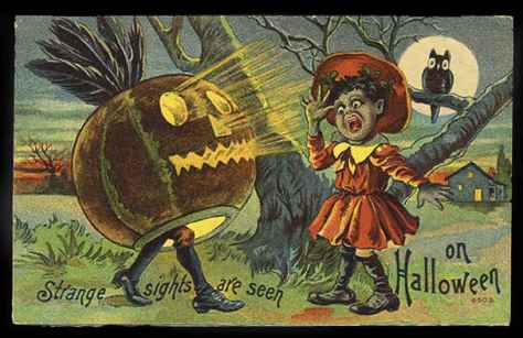
Traditions associated with Halloween which we are more familiar with such as trick or treating, dressing up and pumpkin carving all have their origins in much earlier superstitions.
A Canadian school girls Halloween costume. (1928 – wikimedia.commons)
Thus dressing up was a way to confound the evil spirits who might wish you harm whilst pumpkin carving began as turnip carving. In the United Kingdom a turnip would be hollowed out and a crude face carved into it, then a candle would be placed inside and the whole scary apparition would be positioned in a window – a declaration to all potential ghouls that this house was already haunted. It was also considered a wise course of action to carry said turnip when travelling out and about on this night as a warning to the spirits to keep away. The proliferation of pumpkin jack o lanterns in North America essentially comes down to a lack of turnips…
A Cornish turnip carved for Halloween. (photo courtesy of wikimedia.commons)The well known face of Halloween (with a demonic imp for company).
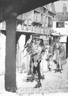
Trick or treating (every childs reason for celebrating Halloween) is a much evolved version of the earlier tradition of ‘guising’, ‘mumming’ and ‘souling’. Guising was were ordinary folk would dress up in bizarre costumes and then would wander door to door singing and performing for wealthier people (mumming). Often the wealthy would share sweetmeats or a cake known as a soul cake in exchange for their prayers for dead relatives (souling). Guising and mumming were not restricted to Halloween. Even today, in the far west of Cornwall guising and mumming are carried out during the midwinter festival of Montol.
An illustration depicting Souling – the verse at the bottom says “Soul, soul, for a soul-cake: Pray you, good mistress, a soul-cake!”
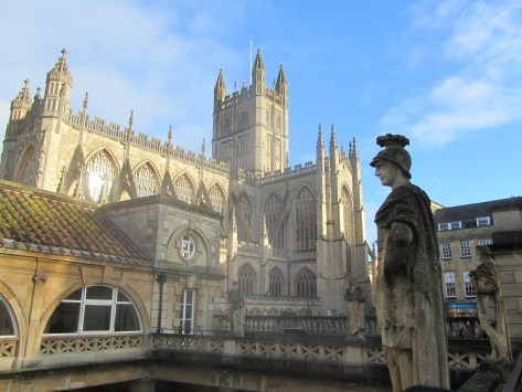
Holidaying in the UK in winter can be rather satisfying. Mainly because you don’t have to contend with the vast crowds which are usual in the warmer months at popular spots. One such place was the Roman bath complex in Bath, here we were able to meander around the buildings and displays without being jostled by eager tourists trying to capture the perfect selfie. This physical space allowed the imagination a chance to wander the halls of time. A multitude of questions and possible scenarios playing out in my minds eye and so ‘A Roman Moon’ was born.
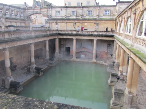
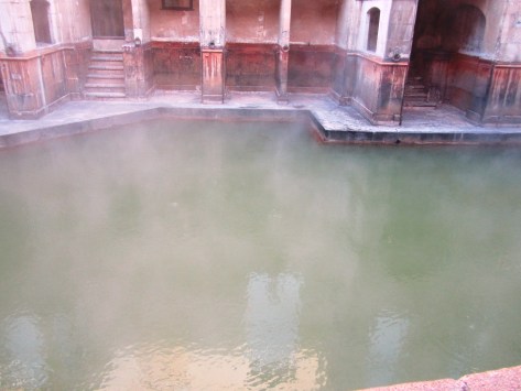
The imposing stucture of Bath Abbey looms over the now open Great Bath – originally the Great Bath would have been roofed, most likely with an arched roof.
Looking down on the Great Bath.
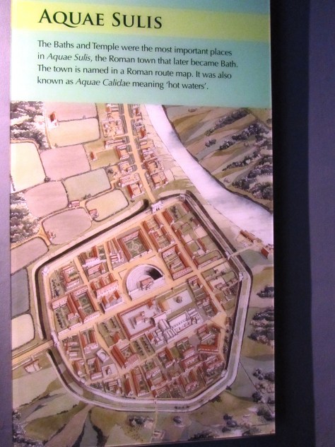
Bath complexes in the Roman period were not simply places to wash and clean the body but also places to meet, socialise, to be seen and make those all important contacts. At the Roman town of Aquae Sulis (Bath) the baths rose to prominence from the late first century AD as a result of the natural hot springs which were a feature of the landscape and worshipped for many generations prior to the arrival of the Romans.
As with so many aspects of the Iron Age/Celtic landscape of the time, the natural springs here had its own diety who was recorded by the Romans with the name of Sulis. The Romans were very good at adopting and blending local cultures with their own as part of their overall colonisation package. For the Romans the local goddess Sulis had much in common with one of their own – Minerva. Thus the hot springs became dedicated to the amalgamated goddess of Sulis Minerva.
The very roman looking head of a statue believed to be Sulis Minerva herself – most likely stood within the sacred space of the actual temple.
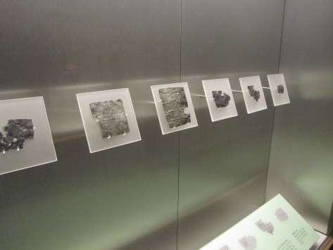
The success of Aquae Sulis (even the towns name pays homage to the goddess – ‘the waters of Sulis’) is down to it also being a place of pilgrimage. People from all around would come to the town to make offerings or petitions to the goddess. One such method to ensure the goddess knew what was required was to write a message on a sheet of lead. For this purpose a trained scribe would be employed. Once the wording was just so the lead sheet was folded or rolled and then thrown into the sacred spring – a number of these have been recovered from the spring, mostly they were curses for relatively small wrong doings.
A few examples of the inscribed lead sheets.
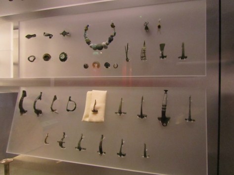
As well as the lead sheets, other gifts were found during excavations. Thousands of coins (and even today people throw coins into the spring), jewellery, pewter dishes and cups usually inscribed with a dedication to Sulis Minerva. The cups may have been used to drink the waters (as we continue to do so today) or as libation vessels. The belief in the healing powers of the spring waters was an important part of the towns fame.
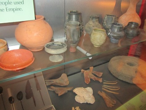
Some of the jewellery finds from the spring. It is interesting to note the continuity of ritual in this act of depositing important items into a watery context. For more on this read here.And a few of the more everyday items found during excavations – people lived and worked here too.
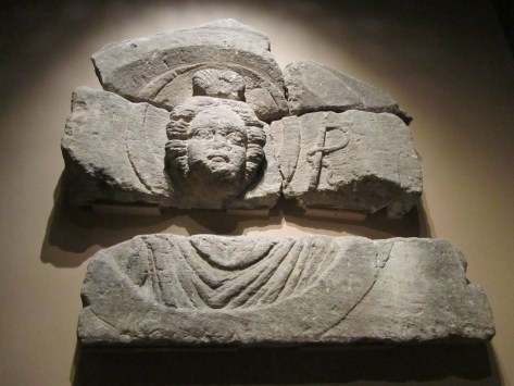
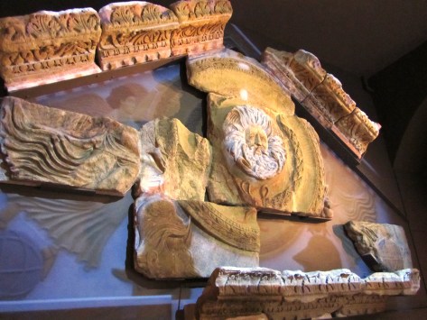
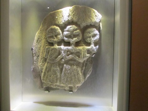
Besides Sulis Minerva there were within the temple complex depictions of other deities.
A relief carving of the goddess Luna – the disc of the moon can be seen behind her head and she holds a whip for driving her chariot across the sky. This carving would have decorated one of the buildings in the temple precinct. This massive pediment would have originally adorned the entrance to the temple of Sulis Minerva. Although interpreted as a gorgon others have suggested it may in fact be Oceanus or even the sun god Sol (or Bel, ‘the shining one’ if you are looking for Celtic diety which is also the nickname of our heroines bodyguard and friend…). This unassuming relief carving is believed to depict the triple goddess, a distinctly Celtic personification. As to who and what this may be is a complicated discussion but foremost is the ability of the goddess to have many faces – to be one and the same. Often the triple goddess in modern pagan/wiccan practice refers to the maiden, the mother and the crone however there is no way of telling if this was the case in the past. An interesting take on this can be read here.
The rituals in Roman religion took place mostly outdoors, the temples buildings were often small affairs where only the priests or priestesses would be allowed to enter. Public ceremonies would have been conducted outside in the surrounding precinct. Within the precinct there would have been altars dedicated to the diety set up by individuals in anticpation of a divine favour or to give thanks, these would have been decorated in offerings of all kinds or with bowls of incense.
“The temple, in its original late first century form, was a purely classical building set on a high podium reached by a steep flight of steps. Its porch was dominated by four massive Corinthian columns supporting an ornate pediment. Behind lay a simple room, the cella, where only priests could enter to tend the flames kept burning around the life-sized cult statue of Sulis Minerva” (from ‘The Essential Roman Baths” – a guidebook).
The above is a selection of the numerous altar stones and memorials found in the Roman layers during excavations.
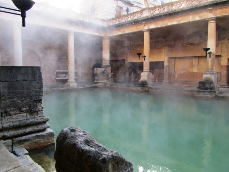
The complex at Aquae Sulis was quite extensive – with facilities for men and women to bath seperately which was rare and spoke volumes about the wealth of the town. At the heart of the complex is the Great Bath, a rectangular swimming bath surrounded by a walkway with alcoves for people to sit and relax in. The bath itself was and still is lined with 45 sheets of Mendip lead.
A model of the bath and temple complex in its heyday.
The Great Bath – looking across to one of the alcoves.
The East Bath – a rectangular tepid bath – the doors would have led to heated rooms known as tepidariums.
The remains of the extensive hypercaust system – ensuring visitors were kept warm and comfortable at all times.
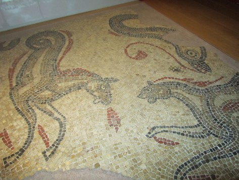
One of many mosaics which would have adorned the floors of the rooms within the complex.
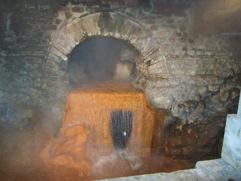
The arched overflow was part of the Roman engineering which kept the water flowing through the complex and still does today.
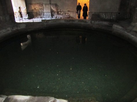
The dark interior of the circular bath, here bathers would complete their visit to the steam rooms with a cold plunge to rinse off – note the coins littering the bottom of the pool.
The complex at Aquae Sulis was quite extensive – with facilities for men and women to bath seperately which was rare and spoke volumes about the wealth of the town. At the heart of the complex is the Great Bath, a rectangular swimming bath surrounded by a walkway with alcoves for people to sit and relax in. The bath itself was and still is lined with 45 sheets of Mendip lead.
A model of the bath and temple complex in its heyday.
The Great Bath – looking across to one of the alcoves.
The East Bath – a rectangular tepid bath – the doors would have led to heated rooms known as tepidariums.
The remains of the extensive hypercaust system – ensuring visitors were kept warm and comfortable at all times.
One of many mosaics which would have adorned the floors of the rooms within the complex.
The arched overflow was part of the Roman engineering which kept the water flowing through the complex and still does today.
The above shows a reconstruction picture of how the town may have looked at its height based upon what has been discovered through various archaeological excavations. In “A Roman Moon” astute readers will note that I did away with the amphitheatre, replacing it with a Forum. Why? Well, to begin with the evidence for an amphitheatre is at this stage is quite thin on the ground and I am sure that a town of such importance would have had a Forum. In addition, you can also put it down to the authors whim, a bit of ‘literary licence’.
The river running beside the town is the Avon, known then as Afon which is Welsh for river (amusingly making the name of the River Avon, the River River)…
I hope you can see why the ancient town of Aquae Sulis inspired me to write ‘A Roman Moon’ – from the presence of Luna, the triple goddess and the sacred spring all play a part in Sarah’s story.
But before we get to pictures, a bit of background…
Built in 1268 by Gilbert de Clare (also known as “Red Gilbert” due to his hair colour) as part of his conquest Glamorgan and the continuing subjugation of the Welsh by the Normans. It is constructed on a natural gravel bank in the middle of a river basin and consists of two large artificial lakes within thirty acres making it the second largest castle in Britain.
The water defences of the castle were most likely inspired by a similar design at Kenilworth which de Clare would have witnessed in action during the seige of Kenilworth in 1266. The vast lakes prevents the castle walls from being undermined – a popular siege tactic at the time. Caerphilly was also the first concentric castle to be built in Britian and its walls were built using Pennant Stone.
A Brief Timeline
1268 – Construction begins with the daming and digging of the lakes, temporary wooden palisades and buildings.
1270 – Rising tensions with Welsh resulted in the castle being attacked by Llywelyn ap Gruffudd and supporters – the wooden structures were burnt to the ground.
1271 – In an effort to quell the tensions between the Welsh and the Normans the castle is taken over by royal officials who promise to negotiate and arbitrate a solution to the ongoing problems.
1272 – de Clare’s men seize back the castle and work recommences, the castle is completed later that year.
1294 – Once again the castle is attacked but this time by Madog ap Llywelyn.
1316 – And again the castle is attacked, during the Llywelyn Bren uprising.
1326-27 – And again during the overthrow of Edward III…
From the fifteenth century the castle begin to decline…
1776 – Caerphilly is acquired by the Marquesses of Bute but it is not until the third and fourth Marquesses that extensive restoration work begun.
1950 – The castle and grounds were given to the state.
Today – The site is managed by CADW – the Welsh heritage organisation.
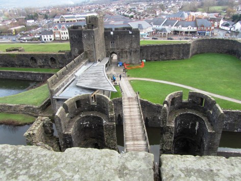
The massive gatehouse entrance – the large tower in the rear of the picture was designed to be defensible postion even if the entire castle was breached. A working portcullis and murder holes are visible today.One of the massive fireplaces in the gate tower.Looking out onto the inner courtyard.Looking down onto the tower gatehouse and outer gatehouse towards town. Originally there would have been a drawbridge across the moat.
This slideshow requires JavaScript.
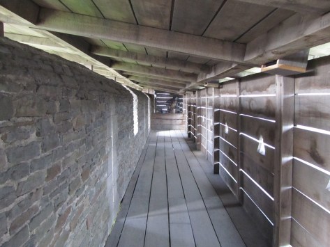
The archers corridor – made of timber with apertures for the archers to aim through and roofed this would have hung of the exterior walls of the castle and provided greater protection to the archers.The leaning tower – natural subsidence or as a result of Oliver Cromwell decreeing that the castle be ‘slighted’ during the Civil War?
This slideshow requires JavaScript.
Caerphilly Castle was a defensive stronghold – the lack of windows and decoration combined with forbidding walls was testimony to this fact – it was a castle which meant business.
More Information can be found at the following links:
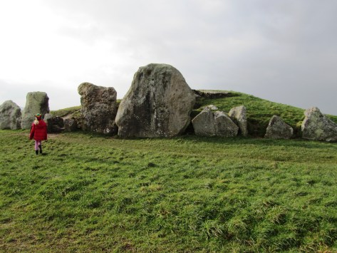
Avebury – the largest stone circle in Europe. It is an easy platitude and just as easily the visitor can wander around the giant stones, exclaiming, wondering why and who built the circle. Then with equal ease get back in their car/tour bus, tick it off the bucket list and move on. However, stop for a moment, look around, peruse the maps and the visitor will see Avebury sits within landscape full of engimatic archaeological sites – West Kennet long barrow and Avenue, Silbury Hill, Windmill Hill, the Sanctuary to name a few. Avebury, the largest stone circle in Europe is but a single element of a much wider sacred landscape.
In fact the Avebury landscape can lay claim to having the largest human constructed mound in Europe (Silbury Hill); the largest long barrow in Britian (West Kennet); one of the largest settlement sites of the earlier Neolithic in Britian (Windmill Hill) and the remains of the longest known avenue of standing stones in Britian (West Kennet Avenue). It would be easy to think that the people of Neolithic Avebury had something to prove but that would be putting modern thoughts of competition into a mindset many thousands of years old.
But lets not jump the gun, first consider what came before the Neolithic and then look at each of the sites individually.
Hunter gatherers in Avebury
To date no single site has been discovered which can be dated to the Mesolithic. In fact the hunter gatherer forebears of Avebury offer up very little in the way of evidence to say ‘we were here’. At the most, isolated findspots of flint tools are known and even these are sparse with just over thirty being recorded. However as many a archaeological lecturer will point out ‘absence of evidence does not equal evidence of absence’.
“As a landscape it is not necessarily empty of significance. There is plentiful ethnographic evidence to show how hunter-gatherer communities invest landscapes with symbolic, mythical and narrative meanings” (Pollard J & Reynolds A ‘Avebury. The Biography of a Landscape’ 2002).
Whilst it might not be obvious to modern eyes the positioning of sites in the earlier Neolithic may well be based on long term community memories, stories and myths which stretch back into the Mesolithic. The simple passing of time reinforcing the importance of place.
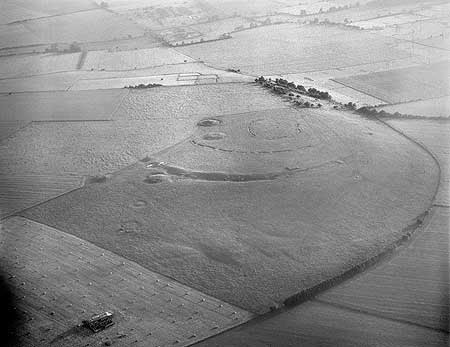
Windmill Hill
Windmill Hill was in use long before the Avebury of today was constructed and is one of a group of early Neolithic monuments known collectively as causewayed enclosures. Numerous examples are known across Britain and although they vary in size and geography there defining feature are the concentric rings of ditches with multiple ’causeways’.
An aerial photograph of Windmill Hill – photo from English Heritage, NMR.
“As the earliest recorded monuments designed to enclose open space, causewayed enclosures represent an unprecedented phenomenon in the archaeological record of the British Isles. The deliberate deposition of artefacts and other cultural material into features dug into the ground represents another important new departure. The creation of the monuments – especially the initial act of defining a place as seperate from the outside world – has therefor increasingly been stressed as a key aspect of their function.”
(Oswald A, Dyer C & Barber M ‘The Creation of Monuments: Neolithic Causewayed Enclosures in the British Isles’ 2001 English Heritage).
Windmill Hill consists of three concentric rings of ditches first dug between 3700-3500BC with a total area of around eight hectares. Within the Avebury area there are a further two similar but less well known enclosures dating to this early Neolithic phase – Knap Hill and Rybury. Windmill Hill has been excavated on several occasions beginning in the late 1920s by Alexander Keiller. Further excavations occured in 1957, 1958 and 1988.
The artefacts found during these excavations represent what can be seen as a microcosm of early Neolithic life. The large quantity of animal bones (mainly cattle) and over twenty thousand pottery sherds represent the importance of raising stock as well as food production and consumption, perhaps in the form of feasting. The one hundred thousand pieces of worked flint; worked sarsen stone; chalk artefacts; antler tools, human bone and axes made of non-local stone represent other aspects of exchange and manufacture; human interactions with the living and the dead.
Beyond the artefacts there is the enclosure itself – for the first time areas of the landscape are being seperated out from their surroundings. Whilst we cannot say for certain it is possible that Windmill Hill was already a place with special meaning and the bounding of the land gave the activities which occured here a greater significance. Evidence demonstrates that Windmill hill was not occupied all year round, most likely from spring to autumn.
“By providing a focus for people to come together on specific occasions, the creation and re-creation of the monuments may have helped to confirm links between groups and individuals, simultaneously establishing a place of lasting significance to all.” (ibid)
The importance of causewayed enclosures such as Windmill Hill should not be underestimated. Windmill Hill provides a point of origin for the development of the later ritual landscape all too evident in the Avebury area.
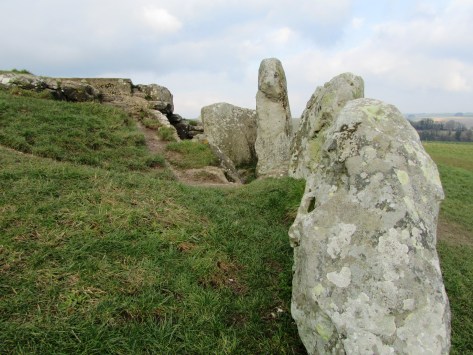
Long Barrows are another type of site which belong to the pre-Avebury stone circle phase and the early Neolithic. Consisting of trapezoidal or rectangular mounds of earth, turf and chalk. There are two types, megalithic or those with stone chambers and non-megalithic or earthen long barrows.
Looking down the megalithic passage.
One of the side chambers.
West Kennet is but one of fourteen long barrows known within a three mile radius of Avebury and is dated to around 3700BC – West Kennet however, is the longest (at 100m long) and the only one in the area which can be easily visited today. Belonging to a group known as the Cotswold-Severn type it was first excavated in 1859 and then in the late 1950s. It consists of five stone chambers connected by stone corridor at its eastern end. The chambers extend twelve metres into the mound and are fronted by an elaborate facade.
My daughter standing on top of the earthern mound of West Kennet.
Human remains were found in all five chambers, which would definitely suggest a funerary function for the site. Initially these were placed in the chambers as whole bodies but over time these were moved around, re-organised and in some cases completely removed (perhaps finding their way to the ditches of Windmill Hill and the like). After the final internments and over several hundred years the chambers were filled in with chalk rubble, pottery debris, animal bones, bone beads, stone, shell and worked flint. Within and on top of this fill other human bones were discovered, mainly of children and most dating to a later period of around 3300BC. There were ten seperate and distinct layers suggesting that this was a deliberate act and not random.
As a final act in the late third millenium BC a facade of three large sarsen stones was built across the forecourt effectively blocking access into the tomb – this act was contemporary with the main stone phase of Avebury; “…closing the monument and marking the end of ‘an older tradition focussed on ancestors and the past'” (Pollard J & Reynolds A ‘Avebury: The Biography of a Landscape” 2002).
The front facade of West Kennet long barrow – note the large blocking sarsens in the center.A view of behind the facade.
Avebury
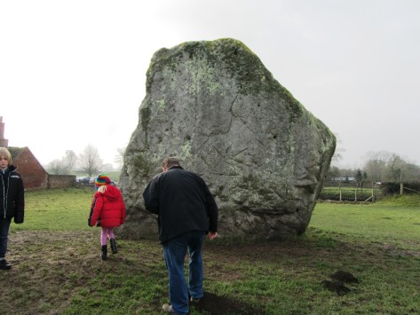
Avebury is approximately 420 metres in diameter and encloses around 11.5 hectares. The bank is on the outside of the ditch and there are four entrances (SSE, WSW, NNW and ENE). The ditch today is four to five metres deep but originally it would have been ten to fourteen metres deep and although grassed over today when first dug the walls of the ditch would have gleamed white, a very obvious feature within the landscape. Contained within the ditch and bank is the largest stone circle in Britain and although many are now missing, it has been estimated that originally there would have been between 95-100 stones around the circumference of the ditch. The largest blocks flank the southern and northern entrances making the route into the centre sinous and not straightforward. At the northern entrance stands a huge stone sometimes referred to as the Diamond Stone and it weighs in at around sixty tonne. Up until the eighteenth century a taller straighter partner stood on the opposite side. The stones are sarsen, a hard grey sandstone with quartz grains. When freshly cut the stones would of looked very different to what they do today.
The Diamond Stone – this has not been moved since it was first placed here in the late Neolithic.
This slideshow requires JavaScript.
One of the most influential people in the recent history of Avebury was Alexander Keiller who undertook many of the excavations in the area during the 1930s and resurrected thirty six of the current stones. When he first bought the land only fifteen of the stones remained upright.
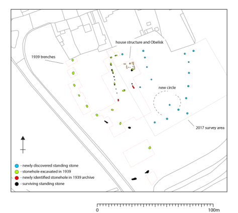
Within the larger circle there are two further smaller circles situated on the saddle of a crest over which the entire monument is situated. In their original form each circle would have had around 25-30 stones and a diameter of approximately 100 metres. In the centre of this were two further monuments referred to as the Cove and the Obelisk. The latter no longer exists but we know of due to William Stukeley who describes it as a pillar 5.5-6 metres high. The Cove are a box like setting of three stones of which only two still remain. In addition, fifteen metres to the west is a thirty two metre long row of nine small reddish stones; roughly half way between the southern small circle and the outer circle is another standing stone referred to as the Ring stone as it is naturally perforated. An aerial survey in 1995 identified numerous parchmarks which may represent more stones.
The smaller northern stone circle
The stone row
Further aerial work, geophysical survey and excavation have identified other features not of stone but of timber and earth. Not much can be said of these features in terms of character and date but it is likely some may be contemporary with Neolithic Avebury. For example, excavations in 1939 at the southern entrance uncovered a substantial 1 metre deep posthole suggesting a pre stone phase of timber posts. In the 1980s geophysical survey suggested the existence of multiple timber circle in the north-east quadrant about forty metres in diameter.
One notable feature of Avebury is the relative lack of prehistoric artefacts. When they are found during excavation they appear to be related to the earliest phases of the monument or its construction. The latter are often referred to as depositional deposits such as the antler picks used to dig the ditch which when the ditch was finished were then deposited on the base, in the primary fill and in the bank.
“We should avoid thinking of the construction of a monument like Avebury as a pragmatic process, as though the sanctity of the site was something conferred upon it once building was complete (not that for much of its early life is ever was). The process of digging ditches, creating banks, dragging in and erecting stones, of ‘altering the earth’, was fundamentally significant in itself – a direct intervention into nature and the cosmos. Indeed, the act of building may have been of as much significance as any completed project.” (Pollard J & Reynolds A ‘Avebury The Biography of a Landscape’)
Another view of the ditch and bank.
Other deposits are found in stone holes or around stones, although only in some parts of the circle. For example, excavations of the southern Inner Circle found a concentration of worked flint particularly around the Obelisk. The south-west sector by comparison was almost clean of artefacts. In the north-west quadrant a variety of artefacts were recovered including sherds of Grooved Ware, human and animal bone, flint flakes, fragments of axes and sandstone implements. Much of this material appears to have been brought in from elsewhere and some are even older than the date deposition.
Of course, all of this is very interesting but what was it used for? Which is of course a million dollar question…interpretations vary and as more research is conducted and more information comes to light so the interpretations change or are tweaked.
The variety of theories include rituals to celebrate certain times of the year; death; transitional periods within life; making contact with the ancestors or the supernatural. Such activities may have been perceived to be dangerous times and hence the act of enclosing the site kept the people safe. Francis Pryor has suggested that the bank outside the ditch allowed people to witness the activities in the interior but at the same time excluded them by the presence of the ditch. The lack of artefacts inside the circle also suggests that this was not a space for just anybody to occupy.
“In one form or another Avebury succeeded the earlier enclosure to the north on Windmill Hill. Both were locations for the periodic gatherings of large numbers of people; these gatherings involved the deliberate burial of artefacts, animal and human remains (though on a much reduced scale at Avebury); at both sites people were involved in a dialogue with spiritual and supernatural agencies…Avebury is more formalised in terms of architecture, and more restricted in terms of how it could be entered and encountered than Windmill Hill – it is less inclusive. But, like Windmill Hill, Avebury also incorporated references to the wider Neolithic social world and surrounding landscape.” (Pollard J & Reynolds A – Avebury. The biography of a landscape.)
Most recently news has come to light of an unusual feature within the centre of the southern inner circle. A research team led by the University of Leicester and University of Southhampton found a series of stone holes which formed a square shaped monument around the now lost Obelisk. Although currently undated, it has been suggested that this may be the oldest part of the entire site and may even be a form of dedication to an even earlier house structure. Only excavation will answer these questions and once again our understanding of this site will need re-evaluating. The team also found evidence for short lines of stones which radiated out from the square to edge of the inner circle.
Squaring the Circle – a blog from FragmeNTS regarding the square monument at Avebury.
From the FragmeNTS blog
The Avenues
In the later part of the Neolithic another type of megalithic monument emerged in the landscape – the Avenues. Leading from the henge at Avebury were two double lines of megalithic stones, one heading from the southern entrance – the West Kennet Avenue; the second heading from the western entrance – the Beckhampton Avenue. Of the two only the West Kennet can be easily walked today.
Both avenues are similar in construction – each are around fifteen metres wide and consist of paired of sarsen blocks that have not been modified. The stones are set every 20 – 30 metres and are around 1.5 – 3 metres tall. The West Kennet leads to the site known as the Sanctuary on Overton Hill and is made up of around one hundred stones. It has been suggested that the avenues were not laid out in one go but were constructed in a series of stages. Dating of the avenues has been relatively problematic due the ‘clean’ nature of the sites, although the Beckhampton Avenue is regarded as being the later monument – but not by much. The current date range is between c.2600-2300BC.
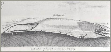
West Kennet Avenue by William Stukeley 1724
The full length of the Beckhampton Avenue is not yet known and was first recorded by William Stukeley in the 1720s and even then it was in a very sorry state. By the nineteenth century only two stones remained upright known as the Longstones (or Adam and Eve). For many years there was some doubt as to what Stukeley recorded but excavations in 1999 and 2000 proved the presence of the avenue and an associated Cove at the Longstones. This area of the Beckhampton avenue underwent a series of changes and readjustments overtime eventually ending with a box shaped setting of stones forming a terminal end to the Avenue.
In regards to purpose it is fair to say that the avenues represent a need to prescribe particular pathways of movement and approach to and from Avebury. It has also been suggested that the processional ways are all about social grading – someone is always in the lead whilst others must follow. In addition, the movement through the landscape also serves as a form of remembrance – linking significant places of cultural memory together.
“At another level, the avenues transformed a landscape of scattered monuments and significant places into a unified complex that was to be approached, read and understood in a very particular way.” (Pollard & Reynold ibid).
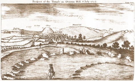
The Sanctuary
As mentioned above the Sanctuary is connected to Avebury via the West Kennet Avenue. Located on the southern spur of Overton Hill it is a complex monument which began life as a circle of timber posts roughly twenty metres in diameter, later becoming a larger double stone circle monument. Although our understanding of the constructional history is not complete it does seem as if many of the timber posts remained in situ during the construction of the stone circles and beyond. Giving an image of a ‘confusing mass of posts’ in both timber and stone. Today the site is marked by two rings of low concrete posts. In the 1720s the field was taken under the plough and the stone removed.
The Sanctuary by William Stukeley 1723 – even Stukeley noted the sites connection to other places of importance in the landscape.
However, it’s importance must not be underestimated. With commanding views along the Kennet valley, the long barrows at East and West Kennet are visible as is Windmill Hill. In addition, there is a long history of activity on the site stretching back into the fourth millenium BC. The most predominant artefact type found on site is flint knapping debris and animal bone, although finds of pottery and human bone were also found as formalised deposits.
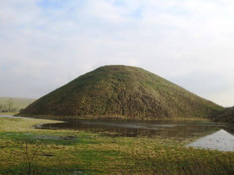
Silbury Hill
Thirty seven metres high, thirty metres across at the top and five hundred metres around the base – Silbury Hill is the largest prehistoric human made mound in Europe and probably the most enigmatic too. It sits on the valley floor close to where the River Kennet rises at the Swallowhead Springs. It seems the construction of the site began around 2400BC although an end date is even less certain. Many attempts have been made to tunnel in to see if anything lies inside and as of yet nothing has been found. Work in 2007 suggests that the mound grew as a result of many small events, giving an image of pilgrimage.
As to its purpose, well…
Final words
There are of course many more monuments within the Avebury landscape – the West Kennet Enclosures; Knap Hill; barrows and other stone circles at places like Winterbourne Bassett – but unfortunately this blog post is already long enough. If you are interested then I do recommend reading Avebury. The Biography of a Landscape by Joshua Pollard and Andrew Reynolds. But most of all I do encourage you to get out and see these places for yourself – it is through experiencing the places of our past do we begin to get a glimmer of understanding.
The following are some online sites that may be of interest:
Postscript – from the Telegraph today we learn that a ‘5000 year old house of the dead’ in the Vale of Pewsey (half way between Avebury and Stonehenge) is to be fully excavated.
The original article from which this post comes from was first published in June 2014 for The Celtic Guide, a free to download magazine.
Water – it is life giving and for some life changing.It shows us a reflection of ourselves and without it we and all around us would cease to exist.It is essential to our being.Many cultures, past and present, have recognised this simple fact.For the ancient Egyptians it was from water that all creation began, in ancient Mesopotamia water was regarded as a symbol of absolute wisdom.In many situations water is given anthropomorphic qualities which are almost always female.Interpretations of the meaning behind the names for the Rivers Dee and Don in Scotland range from ‘the goddess’ to ‘the mother’.Identification with the female is common thread across the world’s cultures.
Today the most sacred river to Hindus is the river Ganges; it is worshipped as the goddess Ganga who descended from heaven to earth.To bathe in the waters of the Ganges is to wash away your sins; her waters are seen as both pure and purifying.It is also believed the Ganges flows in heaven, earth and the netherworld and is regarded as a crossing point of all beings, the living and the dead.Thus it is very desirable to have the ashes of a loved one scattered on the Ganges.This belief in the sanctity of the river, and all rivers, began early in Indian culture and has continued uninterrupted for several thousand years.
Heading far to the west and much closer to home, we arrive in Britain and ask ourselves was water important to our ancestors?The answer would be a definitive “Yes”.In fact, the importance of watery places in Britain’s past is a given for archaeologists and other like-minded individuals.There have over the years been numerous outstanding excavations and archaeological finds to back this up.
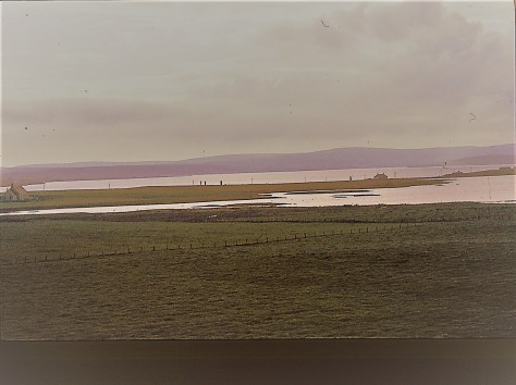
The relationship people had with water in both Britain and Irelands past can be seen as far back as the Neolithic.During this time people were beginning to make their mark on the landscape constructing sizable and (fairly) permanent monuments such as Stonehenge, Ness of Brodgar and New Grange.Such sites are usually part of a wider ‘sacred’ landscape, often surrounded by many other monuments of varying type and size but what is of interest to us here is their relationship to water.Thus the Stonehenge sacred landscape is bounded by the River Avon in the south and east, whilst New Grange and associated sites are nestled in what is known as the Bend in the Boyne (the river Boyne).The Ness of Brodgar, as well as a large number of other sites, in Orkney is situated on thin strip of land with the saltwater Loch of Stenness on one side and the freshwater Loch of Harry on the other.In this landscape there is very little to differentiate the water from the sky.
The view from Maes Howe in Orkney looking towards the Stones of Stenness and what would later be known as the Ness of Brodgar in the top right corner. This sacred landscape is bounded by expanses of water. (please excuse quality of the photo – it was taken a long time ago before digital…)
The reasons for the placement of such sites near rivers may never be fully understood but it is possible to say the symbolism is inherent but as Francis Pryor says in his book Britain BC (2003) “…it would be very easy to oversimplify our reading of that complex, layered symbolism that contained within it the shared histories of the people who created, nourished and guarded it.To say, for example, that water symbolised a soul’s journey to the next world is banal.It may have done – indeed it probably did – but it also marked boundaries in this world, and provided corridors along which people could move without crossing too many tribal frontiers.”
The Neolithic would have been a very alien world to our modern minds and trying to assess the symbolism of a natural phenomenon is fraught with numerous pitfalls.Regardless, it is important to take heed the role of waterways in Neolithic life.The lifestyle of the Neolithic would have been reasonably mobile, with people moving around the landscape following the seasons.
“Where people moved around the land, pathways between places would be emphasised, and monuments placed beside them.Given the scale of many Neolithic monuments, they may also have been placed at locales where groups were in closer proximity at certain times of the year.” (Barnatt J. ‘Monuments in the Landscape: Thoughts from the Peak’ Prehistoric Ritual and Religion. Eds. A Gibson and D. Simpson).
After the Neolithic we have the Bronze Age, a period heralded, as the name would suggest, by the appearance of metal objects (bronze, copper and gold) within the archaeological record.We also see an increasing (albeit gradual) degree of sedentary behaviour, with family type groups concentrating their activities at permanently laid out farms and fields.Many (but not all) of the monuments of the Bronze Age began to reflect this more localised behaviour with smaller monuments being built by these groups for their own use.The monuments are now found in all manner of landscapes and it would it appear that water is no longer of importance.However, excavations at sites such as Flag Fen, Lincolnshire and the finds from Duddington Loch, Edinburgh or the Rivers Thames, Trent or Witham to name a few all suggest that watery places were still of great ritual importance.
In the early days of discovery such finds were often attributed to accidental loss however the excavations at Flag Fen have seem to indicate the majority of the items deposited were done intentionally and with no desire to retrieve them.In 1984 Francis Pryor began excavating a post alignment at Flag Fen.It was 10m wide and consisted of five roughly parallel rows of posts.During the 1989 dig season the excavators began to find some unusual artefacts, some three hundred and twenty metal objects, mostly made of bronze and dating from the Bronze Age.Swords, daggers, jewellery, axe-heads, spearheads and pieces of a metal shield were amongst the artefacts uncovered.Interestingly every object had been deliberately damaged before being placed carefully into the water.The deliberate destruction of artefacts prior to deposition at Flag Fen is not an isolated example.
At Duddington Loch a number of bronze objects were found, mostly weapons, and once more all had been broken or burnt prior to deposition.Still in Scotland, Late Bronze Age swords were found in the River Tay and three Late Bronze Age shields were recovered from a bog in Yetholm, Roxburgshire.Another feature of Bronze Age deposition is its longevity, At Flag Fen and the bog sites of Ireland such as Dowris, Co. Offaly; Mooghaun, Co. Clare and the Bog of Cullen in Co. Tipperary deposition did not occur as a single event rather it was the result of many individual events over a number of years.In the case of the Irish bogs over two hundred bronze artefacts have been found, deposited over a number of years.
A few of the items recovered from Dunaverney Bog in County Antrim, Ireland. From ‘A Guide to the Antiquities of the Bronze Age in the Department of British and Medieval Antiquities’ 1904 Charles Hercules – The British Museum.
The tradition of deposition in watery places continues into the Iron Age. Still the weapons appear in rivers, for example, the Battersea Shield found in the River Thames, a horned helmet from under the Waterloo Bridge and the Witham Shield from the River Witham. An excavation at Fiskerton in Lincolnshire also discovered a causeway that led to Lindsey a significant patch of dry land which is essentially an island bounded by the rivers Humber and Trent to the north and east and the Witham and fens to the south.Here the archaeologists found swords, spearheads and other artefacts deposited into the wet ground.Interestingly it has been suggested that the deposits coincided with periods when the causeway was being rebuilt around the time of lunar eclipses.
The Battersea Shield – photo by Babelstone (CC0 commons.wikimedia.org)
Similar to the Bronze Age, the bogs and lakes of the west seem to be the place of choice for ritual deposition.The most well known is Llyn Cerrig Bach (originally a lake) in Anglesey.From here some one hundred and fifty objects were recovered.The finds from Lylyn Cerrig Bach are regarded as the most important collection of La Tene style metalwork in Britain to be found.The artefacts found included two slave chains, swords, spearheads, a bronze trumpet, cauldrons, iron bars, blacksmith tools and animal bones.Once more all had been deliberately broken and deposited over a long period of time, approximately from 300BC to 100AD.In fact there may have been a double whammy of sacredness here, as it has been suggested that islands represented sacred spaces because they were bounded by water on all sides.
This connection between water and the deposition of weapons is embodied by the later legends of King Arthur.In Malory’s version King Arthur instructs Sir Bedivere “…take thou Excalibur, my good sword, and go with it to yonder waterside, and when thou comest there I charge thee throw my sword in that water”.For some this could be regarded as a cultural memory, a continuation of a ritual performed by our ancestors for many generations.
Sir Bedivere throws Excalibur into a lake – painting by John Garrick 1862.
But it is not only lakes and rivers that were important there were also the peat bogs.Finds from peat bogs are of a relatively common occurrence given the use of peat for fuel.Of course the most famous of all bog deposits are the human bodies. Bog bodies are well known in several European contexts for example, Tollund Man found in a Danish bog.However, there are also examples from Germany, Holland, Norway and Sweden.The tradition goes right back to the Mesolithic and culminates in the Iron Age and early Roman period.
One of the most dramatic discoveries in Britain was that of ‘Lindow Man’ found in a peat bog at Lindow Moss in Cheshire.The remains were of a young male (mid 20s) who had been violently killed from a blow to his head, strangled and a cut to his throat. A detailed examination of the remains suggests he was of a high status.His teeth were healthy, his nails manicured and his beard and moustache neatly trimmed, in addition there were none of the usual signs on the bones that he had ever done any heavy manual labour.Radiocarbon dating has his death and deposition at somewhere in the mid first century AD.
Many reasons for such a grisly deposition have been put forth, from murder and violent robbery to human sacrifice.Sacrifice in the Iron Age was well known and took many forms either as the sacrifice of an object, an animal or a person.
“The Celts did not love their deities; they made contracts with them as they did in their own society.By making offerings into pits, wells, springs, peat bogs and all watery places, no doubt with the solemn attendant ritual, the druids were in fact ‘binding’ the gods into making reciprocal gifts to mankind…” (A Ross ‘Ritual and Druids’ in The Celtic World ed M Green).
It would seem that the greater the ‘ask’ the greater the sacrifice.The Lindow man was deposited at a time of turmoil in Britain, northern England was not properly subjugated by the Romans until well into the first century AD, perhaps he represents a last ditch attempt by the Druids asking for the Gods intervention? Perhaps his grisly death is a reflection of ‘destroying’ an object before it is deposited into its watery grave? Throughout Britan and Ireland there have been almost two hundred documented cases of bodies found in bogs.Not all are dated to the Iron Age and not all can be given a ritual explanation.
Any discussion on the sacredness of watery places needs to include springs and wells. Unfortunately, the majority of springs have been tampered with, cleared out and utilised to such a degree in our history the evidence is very sparse indeed.Some prehistoric sites are associated with springs through proximity such as Swallowhead springs which is near the Neolithic monuments of Silbury Hill and West Kennet long barrow.However, the best preserved piece of evidence comes from the town of Bath.Here we have the very famous Roman baths based around the springs dedicated to the goddess Sulis Minerva.The impressive complex of baths and temples built by the Romans began some fifteen years after the Boudiccan rebellion.It does seem this was an attempt to do honour to a local deity – Sulis – by aligning it with one of the more significant Roman deities – Minerva.It is well recorded by the Romans the importance of this site to the local people.Thousands of coins of both Roman and Celtic type have been found in or near the hot springs in addition to many curse tablets of a Roman date.
This slideshow requires JavaScript.
This tradition of offerings to a spring or well continues into the modern day.Throwing a coin into a well to make a wish is a common practice as is the tradition of well dressing.Every summer throughout the counties of Britain wells are cleaned up and made pretty.The longevity of this practice is well attested, in 960 a canon was issued that expressly forbade the ‘worship of fountains’ and yet it could not be suppressed, eventually the church turned these pagan sites into Christian holy wells.In some cases the well or spring has a special tree nearby, a Clootie tree.The clootie is a piece of cloth that has been dipped in the spring’s water and then tied to the tree, after which a supplication is given to the saint or deity of the spring.Many of these springs are associated with healing, in some cases the clootie represents the ailment and it is believed that once it has perished then so will the ailment.
Clooties hanging on a tree by Madron Well – West Cornwall
Chapel Euny Holywell – West Cornwall. Photo by Frances Watt.
Furthermore it is not unusual for a church to be built near a sacred spring or well such as St Oswalds in Cumbria or at Golant in Cornwall. Some have even embraced the sacred well as is the case for St Winefride’s well in Holywell, Wales. In fact the overall sanctity continues well into the Christian era, monasteries can be found on islands (St Michael’s Mount or Lindisfarne) and many other Christian religious houses are situated close to rivers.
St Winifreds Well, Holywell, Wales. A renown place of healing, it continues to be popular today. This image is available from the National Libary of Wales.
This article merely scratches the surface but from reading and research it soon becomes apparent that water in all its forms has played a major role in the history and prehistory of our world.It has defined where we live and it has defined how we live, indeed if we live at all.That our ancestors’ revered water should be of no surprise to us and yet often it is.
“Water is life’s mater and matrix, mother and medium.There is no life without water.” Albert Szent-Gyorgi
“Nothing is weaker than water, yet for overcoming what is hard and strong, nothing surpasses it.”Lao Tzu
A recent interesting blog from the British Museum which talks about the Thames – “Secrets of the Thames”.
Why fleeting you might ask? Well in a nutshell, the visit occured a couple of years ago during a whirlwind trip to London with the family and after a protracted visit to the Natural History Museum followed by getting distracted by a well known sci-fi shop I was left with a mere two and half hours to see the Museum…As some of you are well aware this is not nearly enough time and so it was, a fleeting visit. The following are a few of the photos I took along with brief explanations.
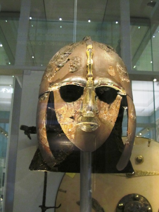
One of the first gallerys I made my way to was the early Medieval gallery – I had long wanted to see the artefacts from Mound 1 at Sutton Hoo, the famous Anglo-saxon ship burial. Sutton Hoo is located near Woodbridge in Suffolk and is the remains of a 6th and 7th century AD cemetary. Mound 1 was excavated in 1939 providing the world with a fascinating glimpse of the artistic ability of our Anglo-saxon forebears. The artefacts were richer and more intricate than any other found before.
The most famous face of Anglo-saxon England – the helmet was in in a bad way when excavated and the above shows only the few remaining pieces which could be salvaged.
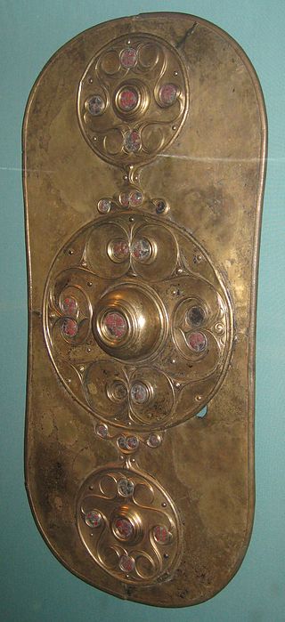
An ornate purse lid – would have originally covered a leather pouch which hung at the waist.
These ornate shoulder clasps are one of kind in Europe and were originally used to hold together the two halves of a stiff leather cuirass so it can fit the torso snugly in the Roman style.
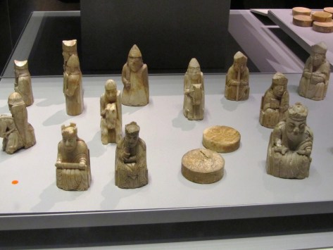
Not far from the Sutton Hoo treasure is the Lewis Chessmen. These fascinating wee carvings were discovered in 1831 in Uig on the Isle of Lewis (Outer Hebrides). They are 12th century in date and carved from walrus ivory; it is believed they were originally made in Trondheim in Norway – at the time the Outer Hebrides were ruled by Norway. A number of years ago, a travelling exhibition on the Vikings came to the Auckland Museum in New Zealand. Two of the Lewis Chessmen accompanied the exhibition and it was this that inspired me to write “A Viking Moon”.
The Lewis Chessmen
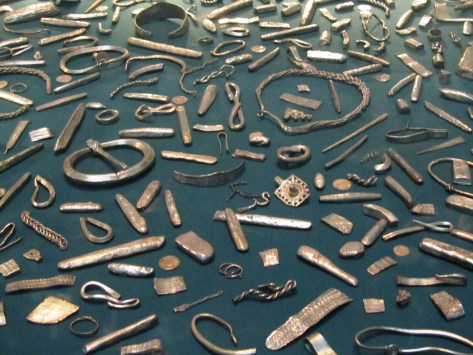
Staying with the Vikings we have the Cuerdale Hoard from Lancashire. The display at the museum is only part an enormous hoard of silver found in a lead chest beside the River Ribble. The hoard itself consisted of 7500 coins and 1200 pieces of silver bullion, weighing in at forty kilograms. The coins come from a variety of sources – mainly the eastern Viking kingdoms of England but also from King Alfred’s Wessex, Byzantium, Scandinavia, Islamic and Carolingian sources. The Ribble Valley was an important Viking route between the Irish Sea and York and this may have some bearing on why the hoard was found here.
Part of the Cuerdale Hoard
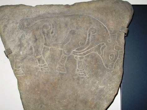
Staying in the early Medieval my next photo is of the Burghead Bull. The town of Burghead in Moray, Scotland occupies part of what was once a Pictish promontory fort of great importance. The Burghead Bulls were discovered in the late nineteenth century when much of the fort was destroyed to make way for more houses. Originally there were thirty panels carrying carved images of bulls, now however, only six remain – one of which is held at the British Museum. They are dated to 5th century AD and it has been suggested they formed a frieze set into the ramparts of the fort and possibly represent a warrior cult which celebrated strength and aggression. Regardless of what the bull represents it is a fabulous piece of Pictish art.
Burghead Bull
Travelling back in time I moved onto the Roman and Iron Age galleries (this was a flying visit, I had just recieved a text from an impatient husband…)
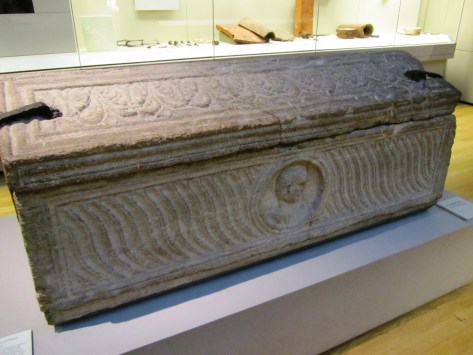
In the Roman gallery I took a moment to admire a stone sarcophagus found in London in 1853 within what was described as an extensive Roman cemetary outside the city wall to the east. It is dated to the early 4th century AD.
An early 4th century AD Roman stone sarcophagus.
Moving along swiftly I found myself in the British Iron Age and here I had to stop and admire the mirrors. Of all the artefacts from this period these are my favorite (and no its not because I have vain streak…). I have long held the belief that mirrors were more than a toilette item for these were never true mirrors that the modern person might be familiar with. Their surfaces were often burnished bronze and would at best reflect a fuzzy image. Instead I would suggest that the surface of a mirror acted in a similar way to the reflective surface of lake, pond or well providing access to the otherworld – a liminal space/place. Such places are well documented as being special, the vast numbersof artefacts found deposited into watery places at this time speaks for itself. Furthermore, it is surely no coincidence that later myths and stories use a mirror as a storytelling device (think Snow White).
The St Keverne Mirror (Cornwall) 120BC-80BC
The Desborough Mirror (50BC-50AD)
The Wetwang Mirror (Yorkshire) 210BC-160BC
Then of course something shiny caught my eye, first the Snettisham Torc and then the twisted gold torcs from the Ipswich Hoard. The Snettisham Torc was discovered in 1950 near the village of Snettisham in Norfolk. It is made up of a kilo of gold mixed with silver, there are 64 threads and each thread is 1.9mm wide, eight threads were pulled together and twisted then all were twisted again to make the torc. The terminal ends are hollow and were cast from a mould. The torc is dated to between 150BC and 50BC. The Ipswich Hoard was the second hoard to be found in the area, the first being Anglo-saxon in date. This particular hoard was discovered during the construction of a housing estate in 1968 by a digger driver and consisted of six twisted gold torcs. These torcs had less silver in them which has led the musuem to date their manufacture to around 75BC.
The Snettisham Torc
The Ipswich Hoard
Finally I wound my way through the Egyptian gallery and down the stairs to meet up with the family who were marvelling at the large statues from the ancient world. The following is a selection of the photos from this part of the museum.
This slideshow requires JavaScript.
There was so much else to see but I simply ran out of time and as we were flying out the next day any other sight seeing would have to wait until another visit – although I have heard recently that there are plans afoot for a downloadable VR experience for those who can’t visit in person.
Below are a few links which relate to the above photos.