Stonehenge may be the most famous, but fascinating prehistoric monuments and sites can be found across England.
Beyond Stonehenge: Where To Find Lesser-Known Prehistoric Sites in England
Stonehenge may be the most famous, but fascinating prehistoric monuments and sites can be found across England.
Beyond Stonehenge: Where To Find Lesser-Known Prehistoric Sites in England
The British countryside is littered with the enigmatic remnants of its ancient past, there are somewhere in the region of ten thousand pre-Roman standing monuments. Modern archaeological techniques and science may be helping us to understand such sites today but once upon a time the people who lived with them found other ways to explain their redoubtable presence. Dating back thousands of years, monuments such as stone circles, standing stones, burial mounds (round and long barrows), stone rows and other such megalithic remains, provide a wealth of folklore as answers to the how, why and who questions of the past.

There are many tales to be told but the following is simply a selection of some well known and some not so well known.
One of the most well-known megalithic sites in Britain is that of Stonehenge with its own fair share of fantastical tales attached. In the 12th century Stonehenge was referred to as the ‘Hanging Stones’ because they appeared to float in the air. Geoffrey of Monmouth writing in the same century declared that Merlin (of Arthurian fame) was responsible for the building of the stones, something which was taken as fact for many centuries.
In Geoffrey’s account the king Aurelius Ambrosius told Merlin he wanted to raise a monument for his nobles who had been killed at Amesbury by the Saxon invader Hengist. Merlin tells the king to fetch a circle of stones in Ireland called the Dance of Giants that had healing properties. Aurelius went to Ireland with an army and fought the local Irish who did not want to give up the Dance of Giants eventually winning. On seeing the size of the stones, they found it impossible to move them, but Merlin was at hand who with the use of ‘his own engines, laid the stones down so lightly as none would believe’.
Of course, we know through scientific endeavor that the largest stones come from nearby Marlborough Downs and the smaller blue stones are from the mountains in Wales, not Ireland. However, it is interesting that there did still seem to be some knowledge, a folk memory, that a part of Stonehenge came from far enough away to be a wonder. It is also of interest that these stones were believed to have healing qualities, as new theories suggest that there was strong connection between healing and the presence of the blue stones in the early phases of construction. Indeed, Geoffrey of Monmouth wrote that they washed the stones and poured the water into baths ‘whereby those who were sick were cured’.
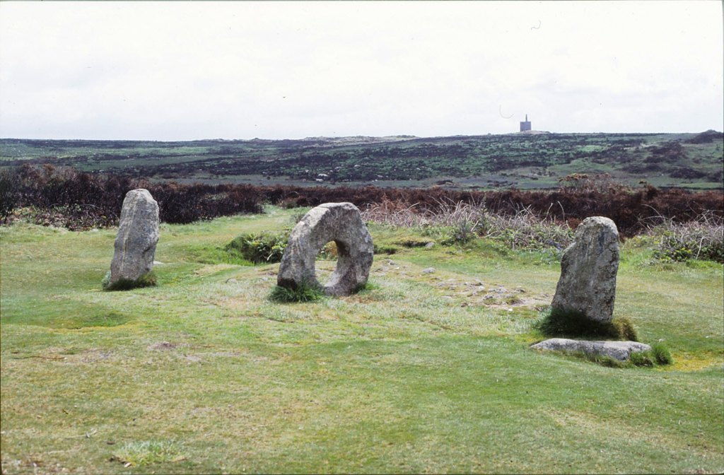
The healing power of certain stones is an enduring feature of the tales associated with them. The most well known is that of Men-an-Tol in West Cornwall, here there is a round upright stone with a hole in it situated between two small uprights. Children were passed through the hole as a cure for rickets; it was also believed to be good for a ‘crick in the neck’ and was sometimes referred to as the Crick Stone – having personally struggled through the aforementioned holed stone, it can be suggested that it causes the ‘crick in the neck’ rather than cures. At Horton in North Somerset there is a similar stone known as the Crick Stone.
In Scotland, at the chamber tomb of Carraig an Talaidh, the portal stone is known as the Toothie Stane as a result of local people who were suffering from toothache would drive a nail into the stone. The idea being that in causing pain to the stone their own would cease. At the Rollright Stones it is said that they confer fertility upon women who touch them with their bare breasts at midnight. In addition, they are offer the power of prayer for the sick a boost if the prayers are said at the center of the Kings Men (the stone circle). The Kings Stone has a peculiar kink as result of the practice of chipping off pieces as good luck charms and amulets against the devil.
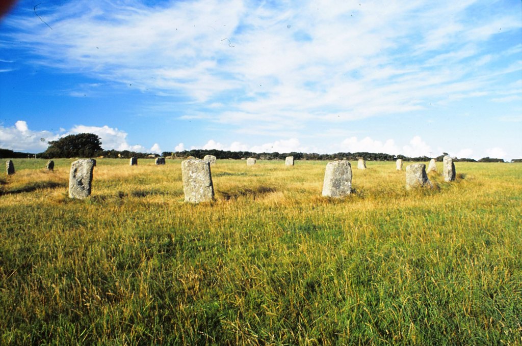
One of the most enduring tales associated with stone circles and standing stones is that of dancing. The Merry Maidens, a stone circle near St Buryan in West Cornwall, is said to be a circle of young girls who were turned to stone for dancing on the Sabbath. In field nearby are several standing stones known as the Blind Fiddler and the Pipers who were playing music for the dancers and when they saw their fate, they tried run but God struck them down turning them into stone. A similar tale is told of the Nine Maidens, also in Cornwall.
A common theme in the folklore of standing stones is of people who broke the Sabbath being punished by being turned to stone, something which would have been encouraged by the Church at the time. The stones represented the pagan and ungodly past, any idolatry of such places was to be discouraged. A classic example of the pagan vs the Christian can be seen in the story of Long Meg and Her Daughters, a stone circle in Cumbria. It was the wizard Michael Scott who when passing the place saw it was a witches sabbath and turned the participants into stone – the use of magic in this instance would appear to not sit comfortably alongside Christian beliefs but then if it is used to do God’s work.
In some cases, Christianity has taken an active role in the creation of the folktales surrounding sites. For example, the Long Stone near St Austell in Cornwall is said to once have been the staff and hat of the Saint Austell. The tale states that the saint was one day walking over the downs when his hat was blown off by a sudden violent gust of wind, he thrust his staff into the ground and chased after it. Unfortunately, the violent wind turned into an equally violent storm, driving the saint back to his home without both his staff and his hat. On returning the next day to retrieve his hat and staff he found that the Devil had turned them into stone.
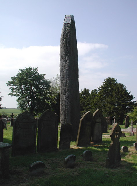
The Devil also features in a legend regarding the Rudston in Yorkshire, this huge monolith stands tall in the local churchyard and the story says that the Devil was up to his usual tricks of throwing stones at Christian places. Picking up a large stone he hurled it at Rudston church, but his aim was lousy, and he missed. The Devil’s Arrows near Boroughbridge consists of three stones and is all that remains of what would have been a very impressive stone row. Legend says that these stones were bolts thrown by an irate Devil aiming for the town at Aldborough and as we have already established his aim was lousy…
An example wrong doer being turned to stone comes from Gwynedd in Wales. The Carreg Y Lleidr stone is said to be a thief who stole some books from a neighboring church and was turned to stone along with the sack of books slung over his shoulder. Here folklore is being used to deter would be thieves and encourage moral behavior.
The connection between dancing and standing stones can also be seen in the notion that at certain times of the year certain stones are reanimated. Thus, Wrington’s Waterstone comes to life and dances on Midsummer’s Day but only when it coincides with a full moon. The previously mentioned Nine Maidens are said to sometimes dance at noon. On Orkney the Yetnasteen, a standing stone in Rousay, comes to life on New Year’s morning when it goes to the Loch of Scockness for a drink. Whilst at the Rollright Stones, the Kings Men are said to resume their human form on occasion, hold hands and dance to a nearby spring to drink.
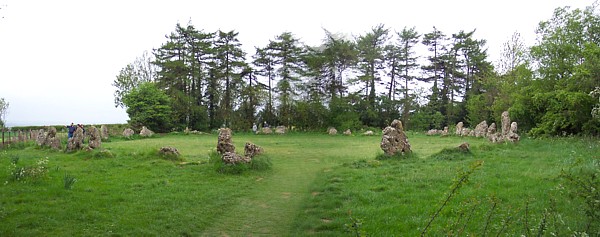
The Rollright Stones (Oxfordshire) have their own creation myth associated with witches and magic. The name itself refers to a group of megalithic structures which includes a circle of seventy-seven stones called the King’s Men, a trio of standing stones which lean together and are called the Whispering Knights and a single standing stone called the King Stone. The legend first recorded in 1586 in Camden’s Britannia tells of how a king was once heading off in an expedition to become the High King of England. When he and his men reached the site where the stones are today, the owner of the land, a formidable witch appeared and told the king:
‘Seven long strides thou shalt take,
And if Long Compton thou canst see
King of England thou shalt be.’
Determined to do just that, he strode forth but as he took his final step a large hillock appeared magically, hiding Long Compton from view. The witch then said:
‘Rise up, stick, and stand still stone,
For King of England thou shalt be none,
Thou and thy men hoar stone shall be
And I myself and elder tree’
Thus, the King and his men were turned to stone and between them up sprouted an elder tree.
Although the elder tree is no longer present, its inclusion in the tale is significant as it represents the pagan aspects of the site. Elder trees were regarded as the most sacred of trees and there are many superstitions and folklore associated with them. The Whispering Knights are said to either be knights who were plotting against the king or praying for him depending on who you talk to. A local legend tells of women who question the stones, leaning in close to receive their wisdom. The King Stone was known as the meeting place of Long Compton’s witches but was also believed to mark one of the entrances to the fairy halls under the circle.
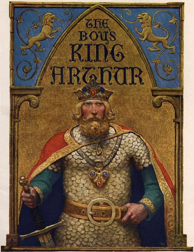
The Rollright stones also have a connection with King Arthur; the tale of King Arthur finishes with him and his knights lying in an underground chamber waiting for time when Britain is in great need. Where this is exactly is of course left to the imagination but for Oxfordshire locals the chamber is located beneath the Rollrights. There are many sites around Britain which attest some connection with the legend of King Arthur, far too many to go into detail here (may be in another post). Suffice it to say that there are very few counties that do not have a stone or two attached to the name Arthur.
As mentioned before Christianity has on numerous occasions used the presence of stone megaliths to demonstrate their own power of good over evil and the importance of being pious. However, they do not always have it their own way. It was the practice of the early church to build their churches on sites of pagan significance, not always with good results. In Scotland near Garioch there is a site called Chapel o’ Sink stone circle, so named because once there were attempts to build a chapel within the stone circle but each night the walls would sink into the ground to such an extent that work was eventually halted, never to be resumed. There are several other similar legends connected with stone circles in Scotland – those called the ‘Sunken Kirk’.
There are also numerous tales of folk who have interfered with the stones much to their own detriment. Death and sudden illness were not uncommon, acting as a deterrent for those who respected the legends. Animals in particular, are said to be affected by changes made to megalithic sites. When the sites of Lanyon Quoit in Cornwall and the Cairnford stone circle in Grampian were threatened with destruction the local farm animals all fell ill – in time when your livelihood depended on those animals this was a disaster. Another tale tells of two stones being removed the Mains of Hatton stone circle in Scotland and being used as gate posts, they had to be replaced as the horses refused to go through them. Similarly in Scotland a stone was taken from the Grenish circle and used as a lintel over the entrance to a cow shed, but no animal would enter from that day on.

At the Rollrights there are also tales of farmers trying to take the stones to use in farm buildings; one farmer in particular, tried to use the capstone from the Whispering Knights as a mill dam, but every night the uncooperative stone returned to its proper place.
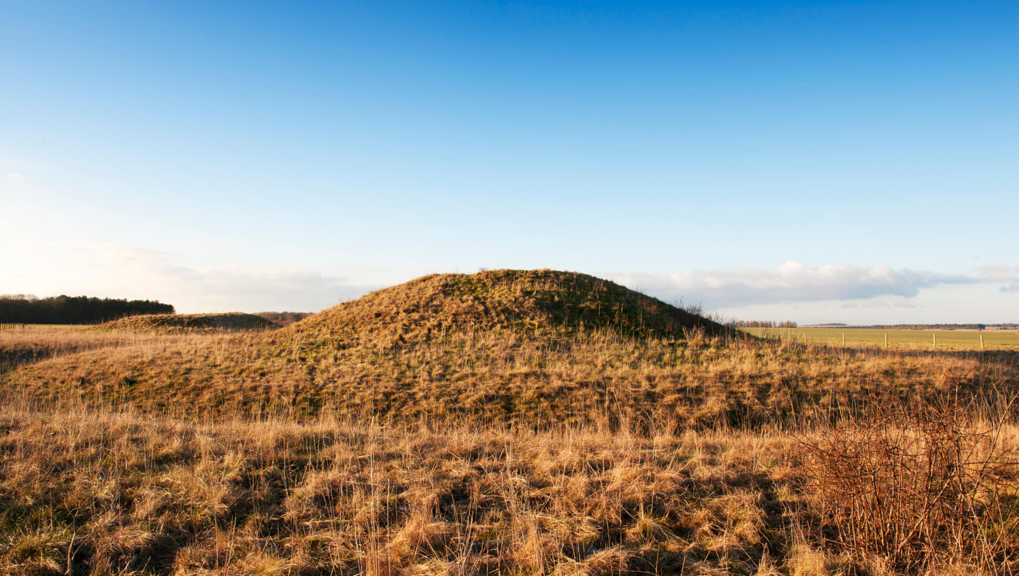
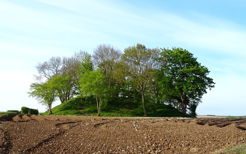
The final site type to consider is that of the barrow. A barrow is in essence a burial mound, some look like pimples on the face of a smooth landscape and others are long mounds built as a statement, many have long gone under the plough and only archaeology can tell they are there. They can range in date from the Neolithic up to the Anglo-Saxon period. The most common stories associated with these types of sites associated these places as the entrances to the Otherworld, a place where the fairy folk abide. Perhaps recalling the stories of the Tuatha De Danaan who were said to have retreated underground on their defeat by the Milesians.
In Tyne and Wear there is a barrow that goes by the name of the Fairies Cradle, it is said that on moonlit nights it is a favorite spot for fairy parades and celebrations. Near Carmyle in Strathclyde there is another barrow called the Fairy Folk Hillock where similarly revels are held by the fairy folk. These are just two examples of the many stories relating to fairy revels at ancient burial sites.
In Humberside the story goes a bit further, here there is a Neolithic long mound called Willy Howe. A chronicler writing in the twelfth century recorded how a man passing the mound found a doorway open on the side, curiosity got the better of him and peered in to find a brilliantly lit chamber in which a gathering of fairies were enjoying a feast. However, he was soon spotted gaping at the door and invited in. His hosts offered him a goblet of wine – anyone who knows anything about the fairy world knows that accepting food or drink there will seal your fate – but not wanting to offend his hosts he accepted and whilst they were not looking emptied the wine onto the ground, fleeing with the goblet. When his story got around, and the goblet inspected no one could identify the metal it was made from. The last recorded location of the goblet was when it was in the possession of Henry II.
The theme of treasure in these enigmatic humps in the landscape is highlighted by the stories of a King Sil and his treasure who was believed to be buried under Silbury Hill in Wiltshire or the gold horse and rider also said to be under Silbury. There are many tales of gold or treasure within the barrows, often such tales resulted in unscrupulous people digging into the mounds in search of such treasure but also tales of the retribution of the fairy folk for those who would dare to interfere with their sacred places. The traditional guardians of hidden treasure are the Spriggans – they would wait whilst the treasure hunter had dug a substantial hole before appearing threatening the would-be robber. Their appearance is said to be so ghastly that the mortal would depart with haste, and should he return later he would find his hole filled in. The stories tell how Spriggans had the ability to grow in size at will and in other tales they are referred to as the ghosts of the ancient giants.
On Dartmoor there is a triple stone row at Challacombe and at its northern end is Chaw Gully, said to be a ‘dangerous place inhabited by malevolent spirits, where rumors of buried gold have led many greedy treasure hunters to their doom’ (A Burnham ed The Old Stones – A Field Guide to the Megalithic Sites of Britain and Ireland).
In Fife there is a hill named Largo Law where it is ‘said that there so much gold buried in it that the wool of sheep turned yellow through eating the grass that grew upon it’ (M Alexander A Companion to the Folklore, Myths and Customs of Britain 2002). But there is also a rhyme that warns against blowing a horn at Largo Law – something a young man named Norrie failed to heed. Norrie blew his horn, no sooner had he finished then he fell down dead, buried where he lay and covered by a cairn now known as Norrie’s Law. Interestingly, a silver hoard was found nearby in 1819, giving some credence to the legend of treasure.
As we read and listen to the stories connected to these ancient monuments we begin to see the world as it may have been to those who came before. The need to explain their presence in the landscape, to understand how they were built and why within a world view that was perhaps much narrower than ours. Even though the number of fringe explanations in todays world would suggest otherwise – the continued insistence that Stonehenge was built by aliens etc is but one example. Telling stories is an integral part of the human world, often as a way of teaching morals and histories, the difference between right and wrong. Thus, whilst some might dismiss folklore as simply fantastical stories they do provide a glimpse into the minds and lives of our ancestors, helping us to understand the past in different ways, to give the past color and multiple facets.
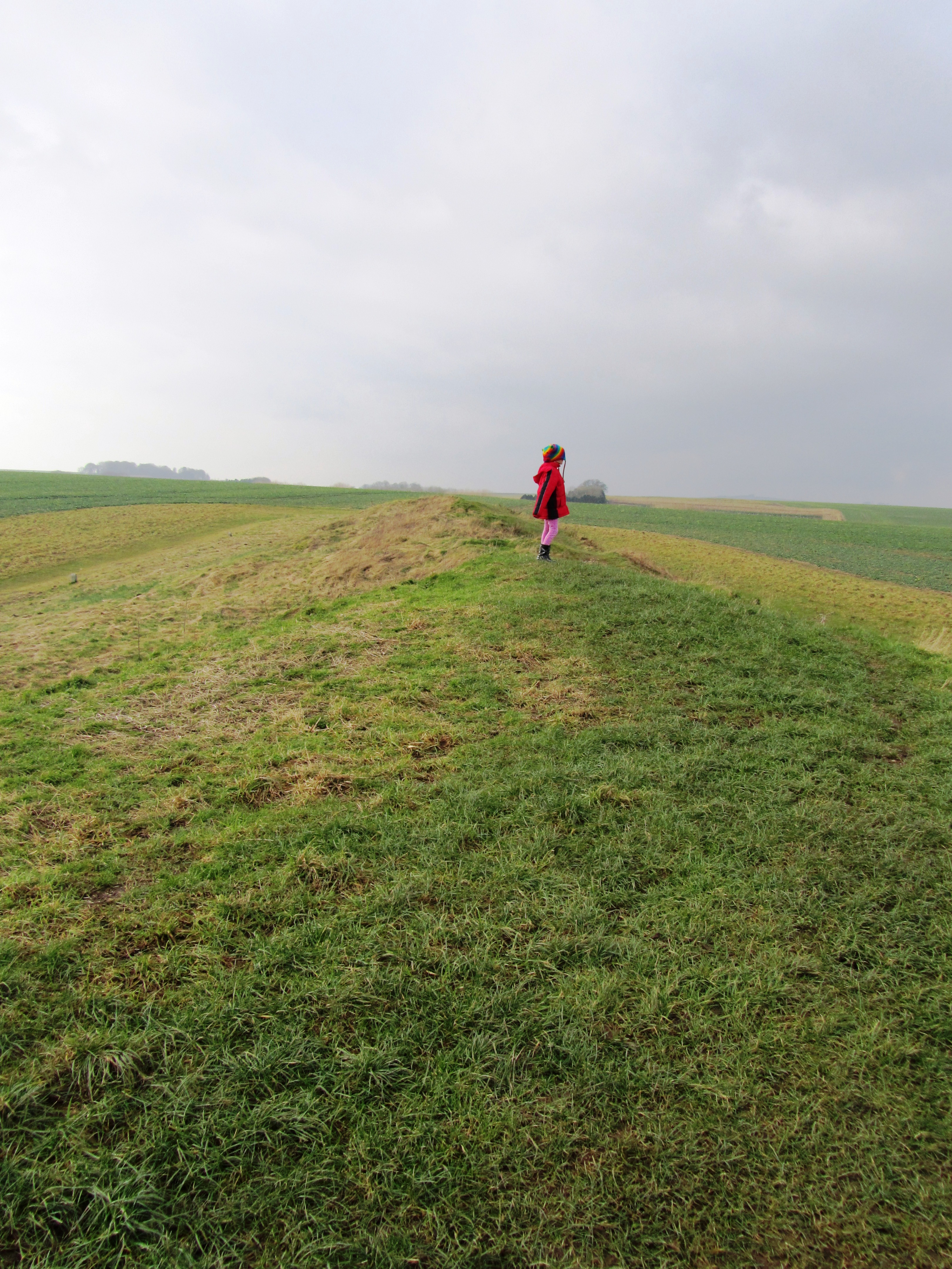
Avebury – the largest stone circle in Europe. It is an easy platitude and just as easily the visitor can wander around the giant stones, exclaiming, wondering why and who built the circle. Then with equal ease get back in their car/tour bus, tick it off the bucket list and move on. However, stop for a moment, look around, peruse the maps and the visitor will see Avebury sits within landscape full of engimatic archaeological sites – West Kennet long barrow and Avenue, Silbury Hill, Windmill Hill, the Sanctuary to name a few. Avebury, the largest stone circle in Europe is but a single element of a much wider sacred landscape.
In fact the Avebury landscape can lay claim to having the largest human constructed mound in Europe (Silbury Hill); the largest long barrow in Britian (West Kennet); one of the largest settlement sites of the earlier Neolithic in Britian (Windmill Hill) and the remains of the longest known avenue of standing stones in Britian (West Kennet Avenue). It would be easy to think that the people of Neolithic Avebury had something to prove but that would be putting modern thoughts of competition into a mindset many thousands of years old.
But lets not jump the gun, first consider what came before the Neolithic and then look at each of the sites individually.
Hunter gatherers in Avebury
To date no single site has been discovered which can be dated to the Mesolithic. In fact the hunter gatherer forebears of Avebury offer up very little in the way of evidence to say ‘we were here’. At the most, isolated findspots of flint tools are known and even these are sparse with just over thirty being recorded. However as many a archaeological lecturer will point out ‘absence of evidence does not equal evidence of absence’.
“As a landscape it is not necessarily empty of significance. There is plentiful ethnographic evidence to show how hunter-gatherer communities invest landscapes with symbolic, mythical and narrative meanings” (Pollard J & Reynolds A ‘Avebury. The Biography of a Landscape’ 2002).
Whilst it might not be obvious to modern eyes the positioning of sites in the earlier Neolithic may well be based on long term community memories, stories and myths which stretch back into the Mesolithic. The simple passing of time reinforcing the importance of place.
Windmill Hill
Windmill Hill was in use long before the Avebury of today was constructed and is one of a group of early Neolithic monuments known collectively as causewayed enclosures. Numerous examples are known across Britain and although they vary in size and geography there defining feature are the concentric rings of ditches with multiple ’causeways’.
“As the earliest recorded monuments designed to enclose open space, causewayed enclosures represent an unprecedented phenomenon in the archaeological record of the British Isles. The deliberate deposition of artefacts and other cultural material into features dug into the ground represents another important new departure. The creation of the monuments – especially the initial act of defining a place as seperate from the outside world – has therefor increasingly been stressed as a key aspect of their function.”
(Oswald A, Dyer C & Barber M ‘The Creation of Monuments: Neolithic Causewayed Enclosures in the British Isles’ 2001 English Heritage).
Windmill Hill consists of three concentric rings of ditches first dug between 3700-3500BC with a total area of around eight hectares. Within the Avebury area there are a further two similar but less well known enclosures dating to this early Neolithic phase – Knap Hill and Rybury. Windmill Hill has been excavated on several occasions beginning in the late 1920s by Alexander Keiller. Further excavations occured in 1957, 1958 and 1988.
The artefacts found during these excavations represent what can be seen as a microcosm of early Neolithic life. The large quantity of animal bones (mainly cattle) and over twenty thousand pottery sherds represent the importance of raising stock as well as food production and consumption, perhaps in the form of feasting. The one hundred thousand pieces of worked flint; worked sarsen stone; chalk artefacts; antler tools, human bone and axes made of non-local stone represent other aspects of exchange and manufacture; human interactions with the living and the dead.
Beyond the artefacts there is the enclosure itself – for the first time areas of the landscape are being seperated out from their surroundings. Whilst we cannot say for certain it is possible that Windmill Hill was already a place with special meaning and the bounding of the land gave the activities which occured here a greater significance. Evidence demonstrates that Windmill hill was not occupied all year round, most likely from spring to autumn.
“By providing a focus for people to come together on specific occasions, the creation and re-creation of the monuments may have helped to confirm links between groups and individuals, simultaneously establishing a place of lasting significance to all.” (ibid)
The importance of causewayed enclosures such as Windmill Hill should not be underestimated. Windmill Hill provides a point of origin for the development of the later ritual landscape all too evident in the Avebury area.
Listing on Pastscape
West Kennet Long Barrow
Long Barrows are another type of site which belong to the pre-Avebury stone circle phase and the early Neolithic. Consisting of trapezoidal or rectangular mounds of earth, turf and chalk. There are two types, megalithic or those with stone chambers and non-megalithic or earthen long barrows.


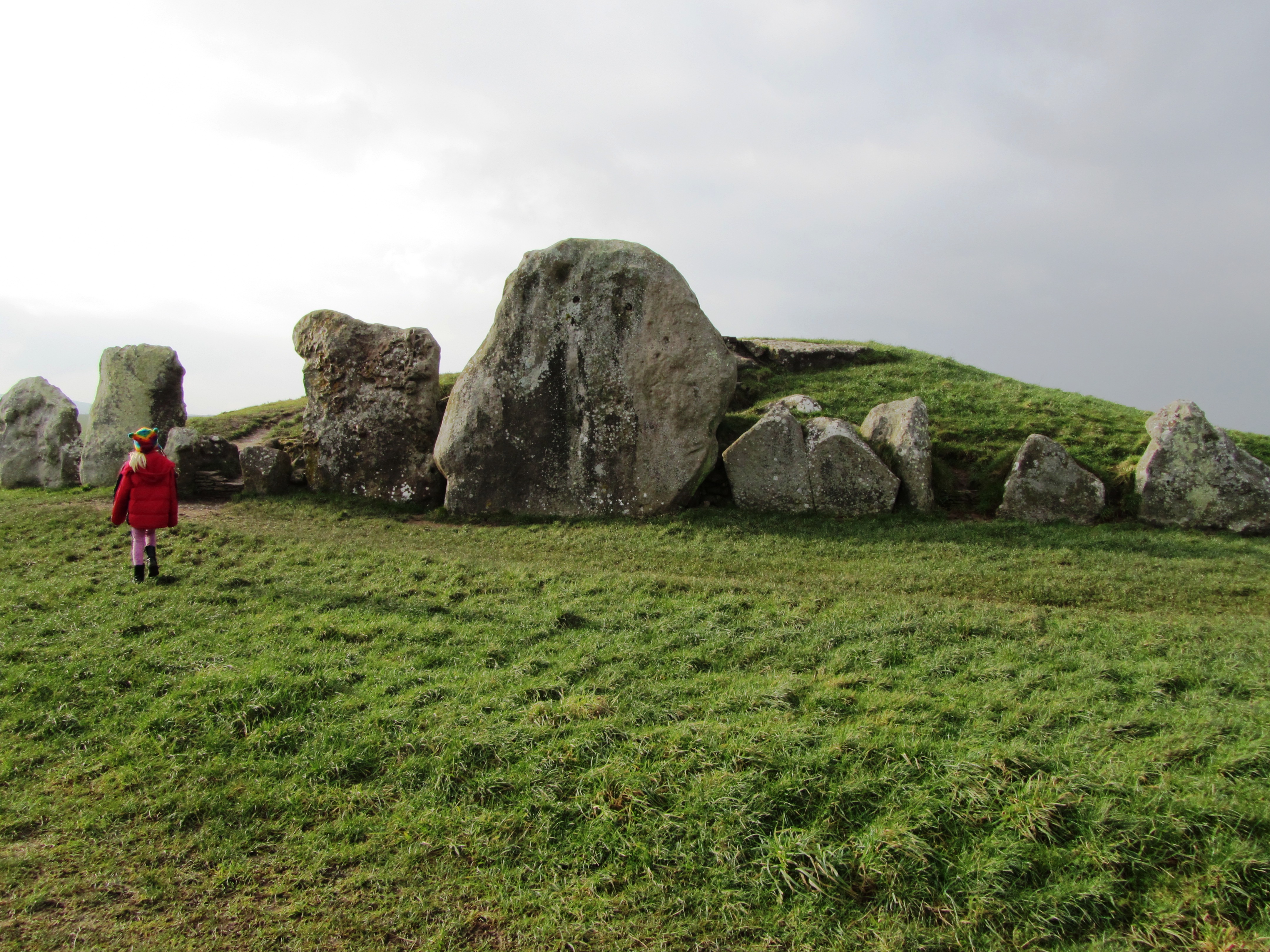
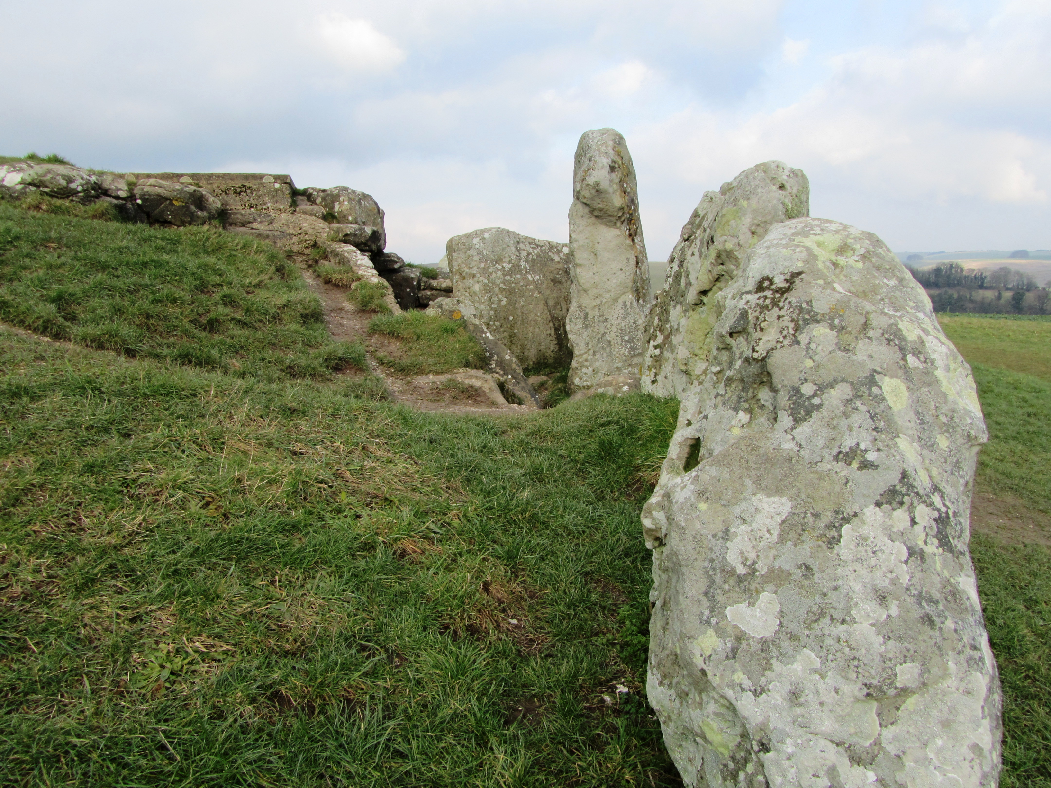
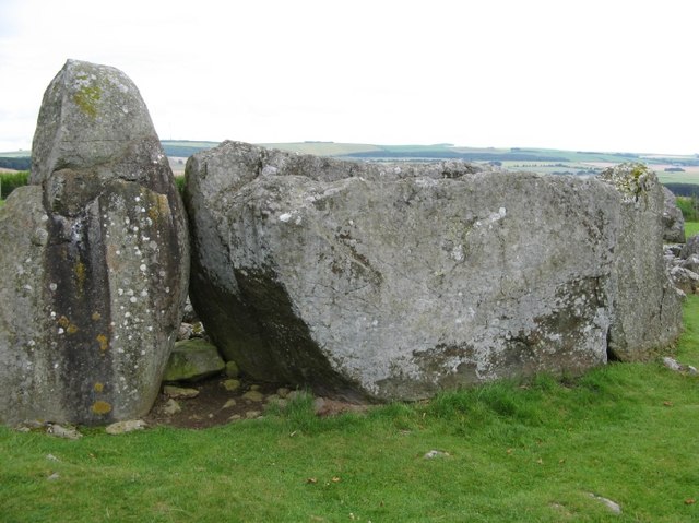
West Kennet is but one of fourteen long barrows known within a three mile radius of Avebury and is dated to around 3700BC – West Kennet however, is the longest (at 100m long) and the only one in the area which can be easily visited today. Belonging to a group known as the Cotswold-Severn type it was first excavated in 1859 and then in the late 1950s. It consists of five stone chambers connected by stone corridor at its eastern end. The chambers extend twelve metres into the mound and are fronted by an elaborate facade.
Human remains were found in all five chambers, which would definitely suggest a funerary function for the site. Initially these were placed in the chambers as whole bodies but over time these were moved around, re-organised and in some cases completely removed (perhaps finding their way to the ditches of Windmill Hill and the like). After the final internments and over several hundred years the chambers were filled in with chalk rubble, pottery debris, animal bones, bone beads, stone, shell and worked flint. Within and on top of this fill other human bones were discovered, mainly of children and most dating to a later period of around 3300BC. There were ten seperate and distinct layers suggesting that this was a deliberate act and not random.
As a final act in the late third millenium BC a facade of three large sarsen stones was built across the forecourt effectively blocking access into the tomb – this act was contemporary with the main stone phase of Avebury; “…closing the monument and marking the end of ‘an older tradition focussed on ancestors and the past'” (Pollard J & Reynolds A ‘Avebury: The Biography of a Landscape” 2002).
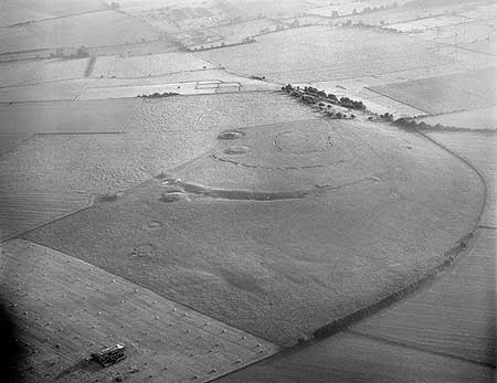
Avebury
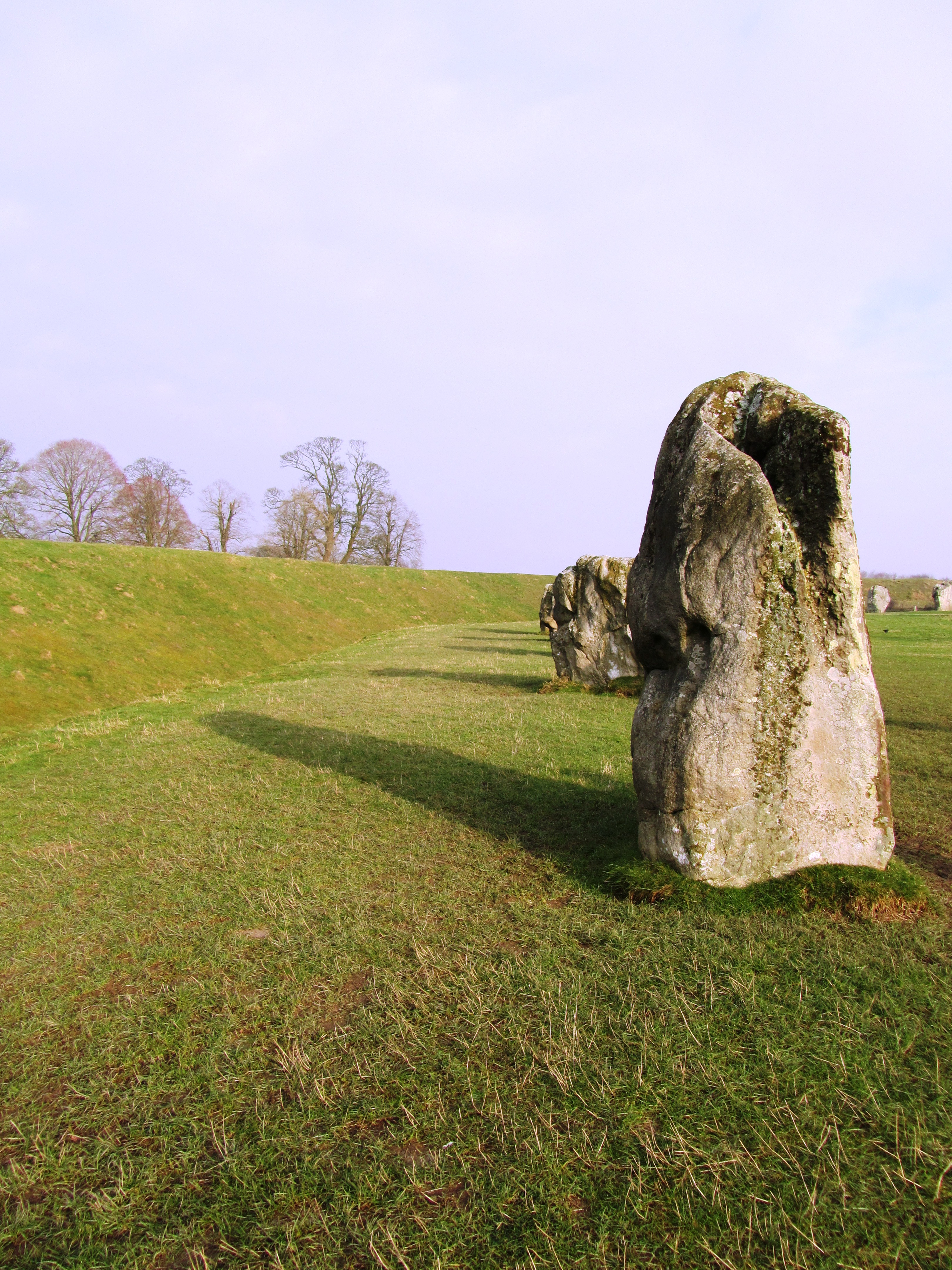
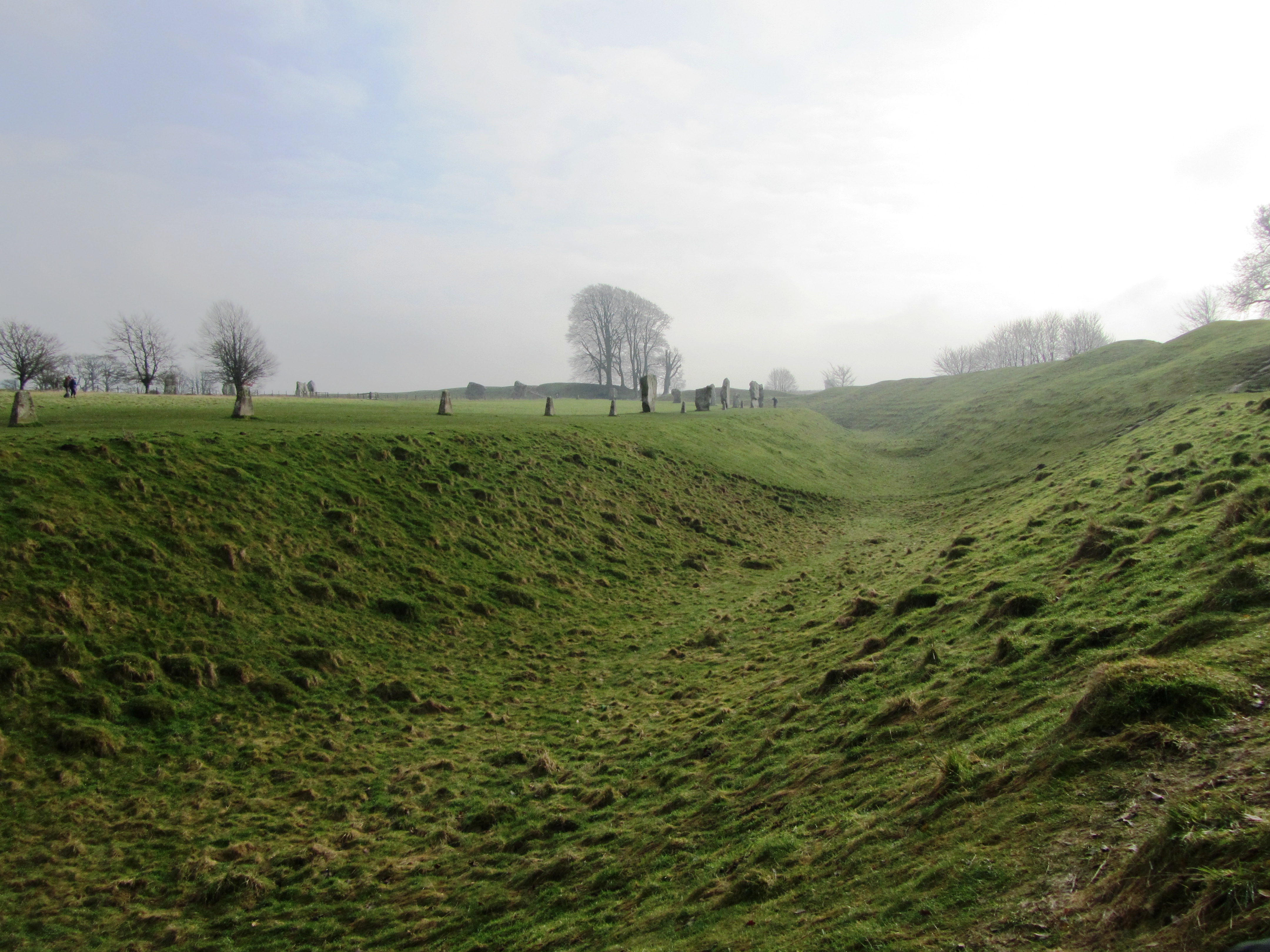
Avebury is approximately 420 metres in diameter and encloses around 11.5 hectares. The bank is on the outside of the ditch and there are four entrances (SSE, WSW, NNW and ENE). The ditch today is four to five metres deep but originally it would have been ten to fourteen metres deep and although grassed over today when first dug the walls of the ditch would have gleamed white, a very obvious feature within the landscape. Contained within the ditch and bank is the largest stone circle in Britain and although many are now missing, it has been estimated that originally there would have been between 95-100 stones around the circumference of the ditch. The largest blocks flank the southern and northern entrances making the route into the centre sinous and not straightforward. At the northern entrance stands a huge stone sometimes referred to as the Diamond Stone and it weighs in at around sixty tonne. Up until the eighteenth century a taller straighter partner stood on the opposite side. The stones are sarsen, a hard grey sandstone with quartz grains. When freshly cut the stones would of looked very different to what they do today.
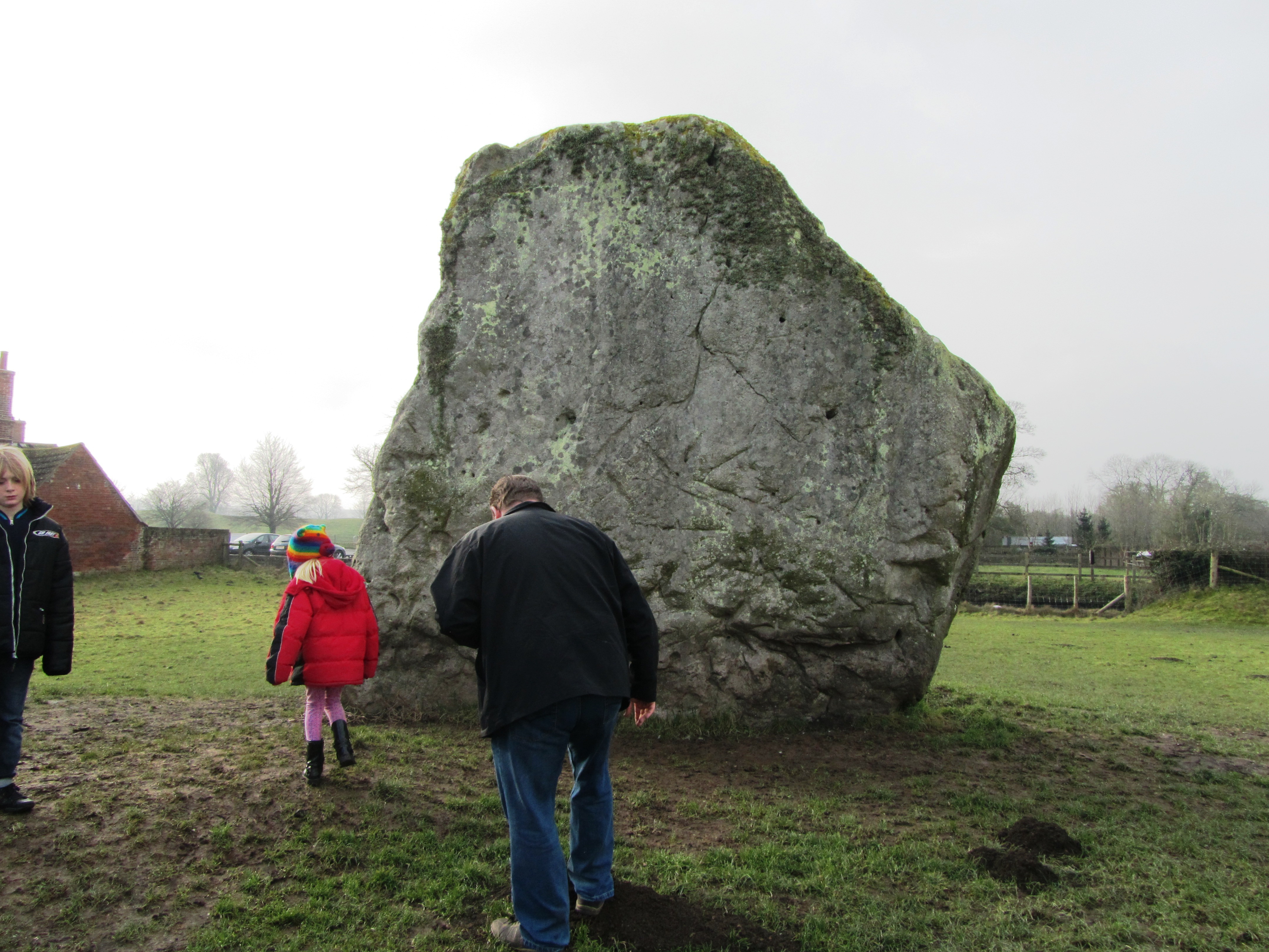
One of the most influential people in the recent history of Avebury was Alexander Keiller who undertook many of the excavations in the area during the 1930s and resurrected thirty six of the current stones. When he first bought the land only fifteen of the stones remained upright.
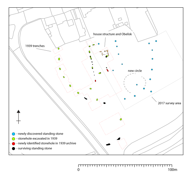
Within the larger circle there are two further smaller circles situated on the saddle of a crest over which the entire monument is situated. In their original form each circle would have had around 25-30 stones and a diameter of approximately 100 metres. In the centre of this were two further monuments referred to as the Cove and the Obelisk. The latter no longer exists but we know of due to William Stukeley who describes it as a pillar 5.5-6 metres high. The Cove are a box like setting of three stones of which only two still remain. In addition, fifteen metres to the west is a thirty two metre long row of nine small reddish stones; roughly half way between the southern small circle and the outer circle is another standing stone referred to as the Ring stone as it is naturally perforated. An aerial survey in 1995 identified numerous parchmarks which may represent more stones.


Further aerial work, geophysical survey and excavation have identified other features not of stone but of timber and earth. Not much can be said of these features in terms of character and date but it is likely some may be contemporary with Neolithic Avebury. For example, excavations in 1939 at the southern entrance uncovered a substantial 1 metre deep posthole suggesting a pre stone phase of timber posts. In the 1980s geophysical survey suggested the existence of multiple timber circle in the north-east quadrant about forty metres in diameter.
One notable feature of Avebury is the relative lack of prehistoric artefacts. When they are found during excavation they appear to be related to the earliest phases of the monument or its construction. The latter are often referred to as depositional deposits such as the antler picks used to dig the ditch which when the ditch was finished were then deposited on the base, in the primary fill and in the bank.
“We should avoid thinking of the construction of a monument like Avebury as a pragmatic process, as though the sanctity of the site was something conferred upon it once building was complete (not that for much of its early life is ever was). The process of digging ditches, creating banks, dragging in and erecting stones, of ‘altering the earth’, was fundamentally significant in itself – a direct intervention into nature and the cosmos. Indeed, the act of building may have been of as much significance as any completed project.” (Pollard J & Reynolds A ‘Avebury The Biography of a Landscape’)
Other deposits are found in stone holes or around stones, although only in some parts of the circle. For example, excavations of the southern Inner Circle found a concentration of worked flint particularly around the Obelisk. The south-west sector by comparison was almost clean of artefacts. In the north-west quadrant a variety of artefacts were recovered including sherds of Grooved Ware, human and animal bone, flint flakes, fragments of axes and sandstone implements. Much of this material appears to have been brought in from elsewhere and some are even older than the date deposition.
Of course, all of this is very interesting but what was it used for? Which is of course a million dollar question…interpretations vary and as more research is conducted and more information comes to light so the interpretations change or are tweaked.
The variety of theories include rituals to celebrate certain times of the year; death; transitional periods within life; making contact with the ancestors or the supernatural. Such activities may have been perceived to be dangerous times and hence the act of enclosing the site kept the people safe. Francis Pryor has suggested that the bank outside the ditch allowed people to witness the activities in the interior but at the same time excluded them by the presence of the ditch. The lack of artefacts inside the circle also suggests that this was not a space for just anybody to occupy.
“In one form or another Avebury succeeded the earlier enclosure to the north on Windmill Hill. Both were locations for the periodic gatherings of large numbers of people; these gatherings involved the deliberate burial of artefacts, animal and human remains (though on a much reduced scale at Avebury); at both sites people were involved in a dialogue with spiritual and supernatural agencies…Avebury is more formalised in terms of architecture, and more restricted in terms of how it could be entered and encountered than Windmill Hill – it is less inclusive. But, like Windmill Hill, Avebury also incorporated references to the wider Neolithic social world and surrounding landscape.” (Pollard J & Reynolds A – Avebury. The biography of a landscape.)
Most recently news has come to light of an unusual feature within the centre of the southern inner circle. A research team led by the University of Leicester and University of Southhampton found a series of stone holes which formed a square shaped monument around the now lost Obelisk. Although currently undated, it has been suggested that this may be the oldest part of the entire site and may even be a form of dedication to an even earlier house structure. Only excavation will answer these questions and once again our understanding of this site will need re-evaluating. The team also found evidence for short lines of stones which radiated out from the square to edge of the inner circle.
Squaring the Circle – a blog from FragmeNTS regarding the square monument at Avebury.
The Avenues
In the later part of the Neolithic another type of megalithic monument emerged in the landscape – the Avenues. Leading from the henge at Avebury were two double lines of megalithic stones, one heading from the southern entrance – the West Kennet Avenue; the second heading from the western entrance – the Beckhampton Avenue. Of the two only the West Kennet can be easily walked today.
Both avenues are similar in construction – each are around fifteen metres wide and consist of paired of sarsen blocks that have not been modified. The stones are set every 20 – 30 metres and are around 1.5 – 3 metres tall. The West Kennet leads to the site known as the Sanctuary on Overton Hill and is made up of around one hundred stones. It has been suggested that the avenues were not laid out in one go but were constructed in a series of stages. Dating of the avenues has been relatively problematic due the ‘clean’ nature of the sites, although the Beckhampton Avenue is regarded as being the later monument – but not by much. The current date range is between c.2600-2300BC.
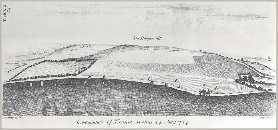
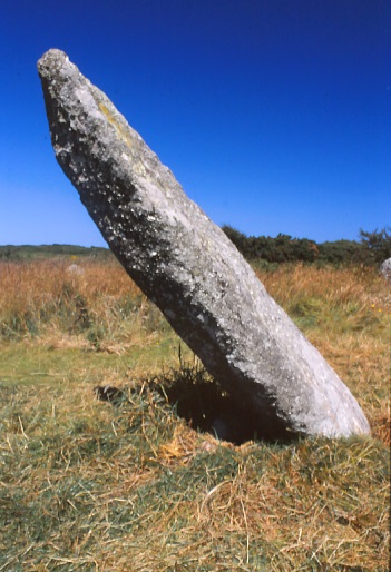
The full length of the Beckhampton Avenue is not yet known and was first recorded by William Stukeley in the 1720s and even then it was in a very sorry state. By the nineteenth century only two stones remained upright known as the Longstones (or Adam and Eve). For many years there was some doubt as to what Stukeley recorded but excavations in 1999 and 2000 proved the presence of the avenue and an associated Cove at the Longstones. This area of the Beckhampton avenue underwent a series of changes and readjustments overtime eventually ending with a box shaped setting of stones forming a terminal end to the Avenue.
In regards to purpose it is fair to say that the avenues represent a need to prescribe particular pathways of movement and approach to and from Avebury. It has also been suggested that the processional ways are all about social grading – someone is always in the lead whilst others must follow. In addition, the movement through the landscape also serves as a form of remembrance – linking significant places of cultural memory together.
“At another level, the avenues transformed a landscape of scattered monuments and significant places into a unified complex that was to be approached, read and understood in a very particular way.” (Pollard & Reynold ibid).
The Sanctuary
As mentioned above the Sanctuary is connected to Avebury via the West Kennet Avenue. Located on the southern spur of Overton Hill it is a complex monument which began life as a circle of timber posts roughly twenty metres in diameter, later becoming a larger double stone circle monument. Although our understanding of the constructional history is not complete it does seem as if many of the timber posts remained in situ during the construction of the stone circles and beyond. Giving an image of a ‘confusing mass of posts’ in both timber and stone. Today the site is marked by two rings of low concrete posts. In the 1720s the field was taken under the plough and the stone removed.
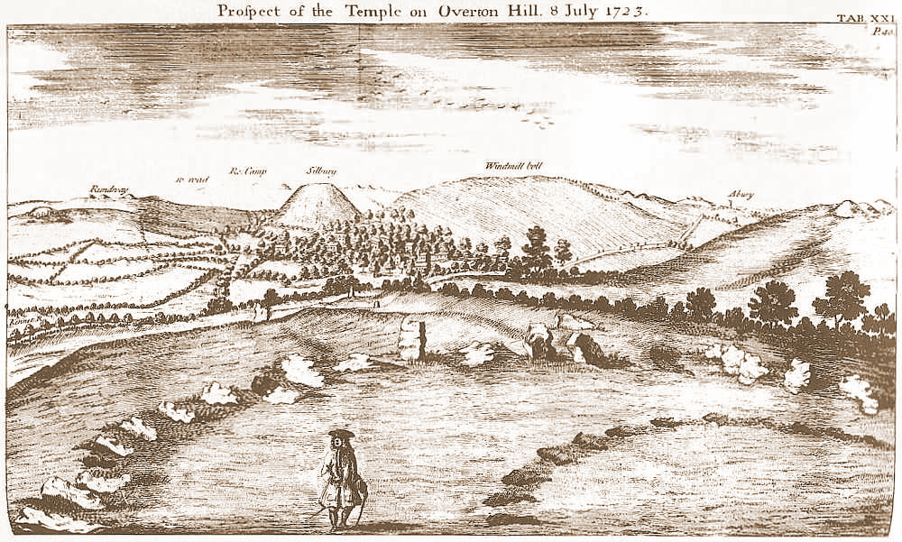
However, it’s importance must not be underestimated. With commanding views along the Kennet valley, the long barrows at East and West Kennet are visible as is Windmill Hill. In addition, there is a long history of activity on the site stretching back into the fourth millenium BC. The most predominant artefact type found on site is flint knapping debris and animal bone, although finds of pottery and human bone were also found as formalised deposits.
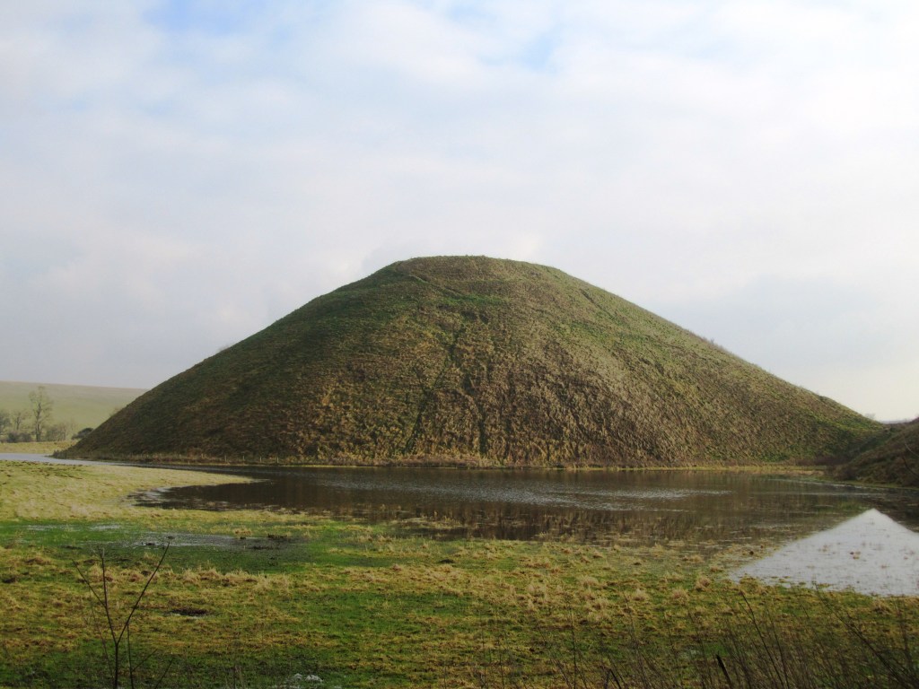
Silbury Hill

Thirty seven metres high, thirty metres across at the top and five hundred metres around the base – Silbury Hill is the largest prehistoric human made mound in Europe and probably the most enigmatic too. It sits on the valley floor close to where the River Kennet rises at the Swallowhead Springs. It seems the construction of the site began around 2400BC although an end date is even less certain. Many attempts have been made to tunnel in to see if anything lies inside and as of yet nothing has been found. Work in 2007 suggests that the mound grew as a result of many small events, giving an image of pilgrimage.
As to its purpose, well…
Final words
There are of course many more monuments within the Avebury landscape – the West Kennet Enclosures; Knap Hill; barrows and other stone circles at places like Winterbourne Bassett – but unfortunately this blog post is already long enough. If you are interested then I do recommend reading Avebury. The Biography of a Landscape by Joshua Pollard and Andrew Reynolds. But most of all I do encourage you to get out and see these places for yourself – it is through experiencing the places of our past do we begin to get a glimmer of understanding.
The following are some online sites that may be of interest:
Avebury: A Present from the Past


Postscript – from the Telegraph today we learn that a ‘5000 year old house of the dead’ in the Vale of Pewsey (half way between Avebury and Stonehenge) is to be fully excavated.
In the second novel – A Megalithic Moon – our heroine, Sarah, finds herself transported back in time some five thousand years (ish). For archaeologists and those with an interest in the past this is the Late Neolithic, a time of massive stone constructions, of megaliths, of stone circles.
For many years stone circles have fascinated me and so I was really very keen to weave these monuments into Sarah’s story. There are some 1300 recorded stone circles in Britain and this is not the place to discuss each and every one of them. Instead I wish to look at two stone circles in particular which feature in A Megalithic Moon, Boscawen Un and Loanhead of Daviot. For those who want to find out more about stone circles I highly recommend Aubrey Burl’s The Stone Circles of Britain, Ireland and Brittany published by Yale University Press (2000).
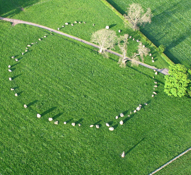
In the very early pages of A Megalithic Moon the reader is introduced to one of my all time favourite sites – Boscawen Un – a stone circle in the heart of West Penwith, Cornwall.
Boscawen Un
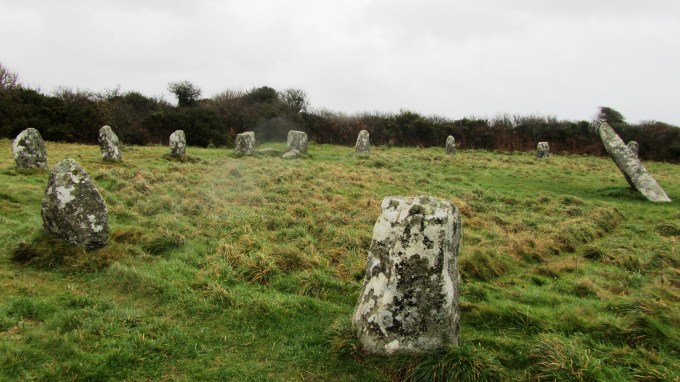
Not a true circle the stone ring measures 24.9m and 21.9m in diameters making it more elliptical than circular. The ring consists of nineteen stones varying in height from 0.9m to 1.3m and has two unique features. Firstly there is a central stone which leans sharply to the north east. Originally it was believed that the lean on the central stone was the result of people digging for treasure believed to be at its base but recent archaeological work has confirmed that the stone was deliberately placed in the ground at a lean. Another interesting fact about the central stone is the presence of two faint, but real, carved axeheads near the base which can best be seen at the midsummer sunrise.
Secondly all but one of the stones are of local granite, the odd one out is a solid chunk of white quartz. For those of a pagan leaning, the quartz stone is significant as it serves to represent the feminine lunar deity (and thus the central stone is the male). Quartz is often found on sites of ritual significance, the Duloe stone circle (also in Cornwall) is smaller but all of the stones are quartz. Excavations at the Hurlers, a stone circle complex on Bodmin Moor, uncovered traces of a quartz pavement which highlights the importance of this material in the rituals of the past. It is easy to imagine how the quartz in its freshly cut state might glow in the light of the moon. The use of quartz is not restricted to Cornwal and much further afield in Aberdeenshire the recumbent stone circles often feature quartz.

The circle was restored in 1862 when three stones were re-erected and the hedge which originally cut through the ring was diverted around it. Historically Boscawen Un was believed to be the Beisgawen yn Dumnonia named in the Welsh Triads as one of the ‘Three Principal Gorsedds’. So much so, in 1928 the modern Cornish Gorsedd was inaugurated here. Unfortunately recent academic work by Rachel Bromwich revealed that the Triads were in fact an eighteenth century forgery.
There is a west facing gap which may represent an entrance not unlike the one found at the Merry Maidens, another well known stone circle in West Cornwall, which can be seen from Boscawen Un.
Much later in A Megalithic Moon the reader is introduced to another kind of stone circle but much farther away, those of north east Scotland in Aberdeenshire. Recumbent stone circles are so called due to a common feature of a large single stone lying ‘recumbent’ between two flanking uprights. The recumbent always occupies a position on the circles arc between SSE – SW and the uprights are graded in size from the smallest on the northern arc and the tallest flanking the recumbent. They are unique to this area of Scotland and are not found elsewhere except for in the south west of Ireland.
Unfortunately, agricultural practices of the 17th and 18th centuries resulted in many of the circles being destroyed. Some well preserved examples which are worth a visit include Loanhead of Daviot, Easter Aquorthies, Sunhoney and Tyrebagger.
Loanhead of Daviot
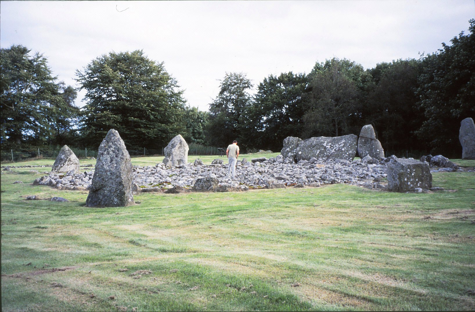
This recumbent stone circle is situated near the summit of gentle hill overlooking the village of Daviot and few miles from Inveruries. Excavations conducted in 1934 provided evidence for the longevity of the site from the late Neolithic through to the Iron Age. The site itself consists of two concentric rings of stone with a central cairn. In addition adjacent to the main stone circle is a late Bronze Age cremation cemetery.
The outer circle is 19.5m in diameter and is made up of ten upright stones and one recumbent. Around the base of each upright a small cairn of stones were piled and in some evidence of burials were found. Several of the uprights also have faint cupmarks engraved into the stones surface.
The inner circle is 16.5m in diameter and forms a kerb of low stones to the central cairn which was built over a cremation pyre. Here some 2.3kgs of burnt bone lay in the central space. Interestingly the type of stone to be found in the central cairn consists mostly of quartz.
Just north of Loanhead a second recumbent is known, however all that remains is the recumbent itself and its two flankers. A third circle was recorded in the 18th century to the south of Loanhead in the village of Daviot, sadly nothing remains of this circle.
Stone Circles and the Moon
A great deal has been written about the astronomical associations between megaliths and the night sky. In relation to stone circles it was Aubrey Burl who pointed out that a circle is not the most efficient means to observe the night sky, rather a single line of stones would work considerably better. Indeed there are scattered throughout the British landscape enigmatic lines of stones and often in association with stone circles, such as the previously mentioned Hurlers on Bodmin Moor.
So if stone circles are not for astronomical observations, what are they for? Increasingly, there is a body of work which is leaning towards a lunar and/or solar explanation. Often the emphasis is on the solstices, the rising and setting sun, midwinter and midsummer being the most popular. However, there is some suggestion that the spring and autumn solstices were just as important if not more so, particularly in Cornwall where the people of the Neolithic and Early Bronze Age were most likely to be pastoralists rather than agriculturalists.
In regard to the recumbents of Aberdeenshire it appears to be the procession of the moon which was important. Thus the recumbent were laid in line with the southern moon but not as it rose or set but when it was actually up in the sky.
“The majority of the recumbent lie in the arc between the moon’s major rising and setting…” Aubrey Burl p227 The Stone Circles of Britain, Ireland and Brittany.
Another feature of these recumbent circles is the presence of both quartz and cupmarks and again an association with the moon could be made. The quartz shining brightly in the moonlight perhaps representing pieces of the moon itself and the cupmarks themselves do seem to generally align with either the major or minor moonset or moonrise.
“To the users of the circles it may have been the steady procession of the moon above the recumbent that was wanted rather than a particular moment, minutes of moonlight when quartz glowed luminescently and when nocturnal ceremonies where performed.” Aubrey Burl p226 ibid.
And so, all of these elements are woven throughout Sarah’s story and have become my inspiration for the Daughters of the Moon – the Myhres an Loor.
Please find below some links to interesting websites about stone circles and megaliths in general. Enjoy!
Stone Circles of North East Scotland
//www.smashwidgets.com/1/widgets.js


