Tag Archives: Mining

The Tinners Way – An Old Track Through Time.

In the far west of Cornwall lies a trackway that has been trodden by many feet over many millennia.  Once a central part of a wider network of tracks it is now only used by ramblers, dog walkers, horse riders and those interested in the sites along its way.  What it was called in the past is unknown but today it has become known as the Tinners Way.

Paths and tracks traverse the landscape creating a maze of possible routes from A to B and are probably one of the least understood aspects of the past in Britain.  The greatest issue is in the understanding of the chronology of this particular site type.

“Unmetalled roads and trackways are extremely difficult to date.  They have no constructional material to aid interpretation and artefacts are rarely present.  This difficulty is compounded by the fact that their form has remained unchanged from prehistoric to modern times and that many were in continuous use for centuries, even millennia” (Prehistoric Roads, Trackways and Canals – Historic England 2011)

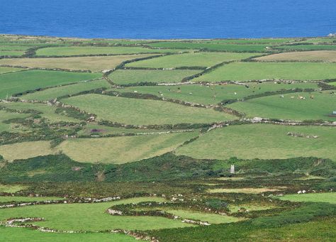
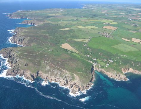
Historic England/English Heritage have defined a trackway as a ‘linear route which has been marked on the ground surface over time by the passage of traffic.  Trackways are usually relatively short routes for local use’.   In west Cornwall the Tinners Way has been identified as one such trackway, one which in all likelihood has a lengthy history going back into prehistory.  It follows the granite backbone of West Penwith passing by and sometimes through archaeological sites as well as the remains of later of tin mining.

So, from where does the Tinners Way begin and where does it end?  Well the answer to that would very much depend on from what direction you are coming as it travels between Cape Cornwall and St Ives.  For our purposes here we will begin at Cape Cornwall in the very far west, stopping at various points and ending up on the  Island in St Ives.

kenidjack_valley_meets_the_sea_-_geograph-org-uk_-_493077
Kenidjack Valley with Cape Cornwall in the background – photo by Tony Aitkin (geograph.co.uk)

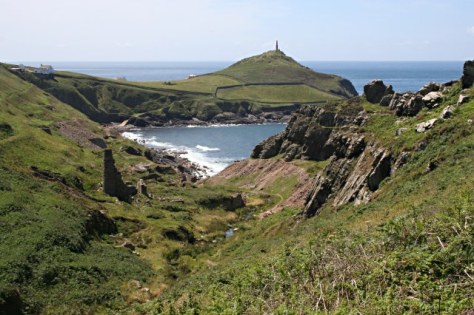
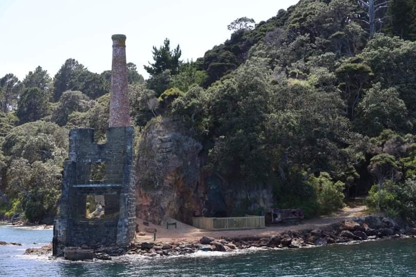
It is probable that the Kenidjack Valley which runs alongside the Cape was the source of one of the earliest and most accessible deposits of alluvial tin ore.  Tin was an important resource to the Cornish economy from the Bronze Age into the 19th century. 

img_0033
The bracken covered sides of Kenidjack Valley hide the remains of alluvial mining.

.

img_0044
A view of one of the trio of stone circles known as the Tregeseal stone circles with Carn Kenidjack in the background.


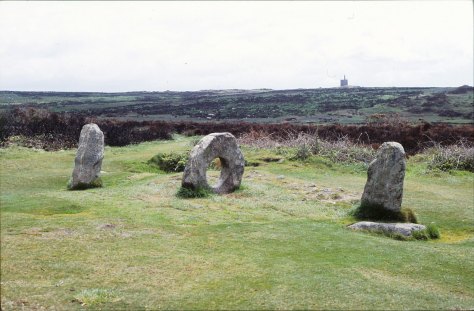
From here the trackway heads inland and up onto the moors of Penwith past Carn Kenidjack and the Tregeseal Stone Circles not to mention the mysterious holed stones.   Continuing on to the fascinating sites of Chun Quoit and Chun Castle.

chunquoitborlase2
Chun Quoit – drawing by William Copeland Borlase 1872

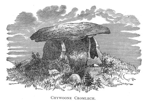
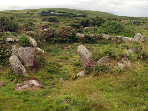
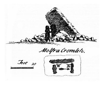
Back long before metals were exploited in Cornwall our Neolithic  ancestors built great stone tombs, archaeologically these are known as quoits or chambered cairns.  Although this is not the place to go into a lengthy discussion on the function of such sites it should be pointed out that many of these sites do seem to appear in significant places in the landscape and thus would seem to have a function beyond simple burial.  Along the Tinners Way there are several quoits which serve to mark the way – Zennor Quoit, Mulfra Quoit, and of course Chun Quoit with the possibility of more having been ravaged by time.

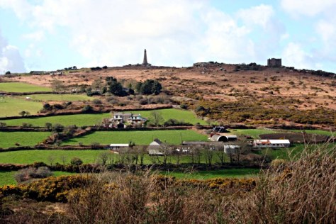
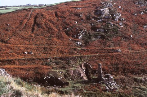
Just past Chun Quoit are the remains of what was once a great stone walled hillfort – Chun Castle.  The walls are still impressive even after the attempts at removal for use in other building projects (the pavement on Market Jew St in Penzance is made up of stone from the hillfort).  Originally occupied in the Iron Age it straddles the trackway, interestingly it was later occupied in the 5th and 6th centuries – a time of unease – and the evidence does seem to suggest it was used as a stronghold for the storage of tin ore.

chuncastleknight
Plan drawing of Chun Castle by Charles Knight 1845.


chun_castle_-_geograph-org-uk_-_1065624
The imposing gateway of Chun Castle – photo by Rod Allday (geograph.co.u


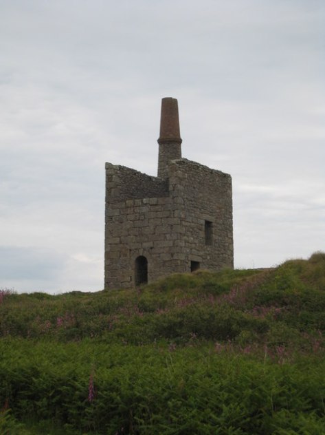
All along the Tinners Way there is evidence of tin mining (hence the name) – old mine shafts can be a hazard for those wandering off the beaten track (please remember to keep your dogs under control when walking along here).  Much of the visible mining remains date from the 17th to the 19th centuries.

greenburrow_pumping_engine_house_at_ding_dong_mine_-_geograph-org-uk_-_846597
The pumping engine house over the Greenbarrow shaft of Wheal Malkin often referred to as Ding Dong Mine – photo by Rod Allday (geograph.co.uk)

On leaving Chun Castle you pass the overgrown Iron Age courtyard house settlement of Bosullow Trehyllys – see an earlier article on the more well known courtyard house settlements of Chysauster and Carn Euny.  From here the trackway follows the well trod path past the Men-an-Tol and Men Scryfa.

img_0039
Men-an-Tol – the moorland behind is covered in disused mining shafts.  In the far distance is the abovementioned pumphouse of Ding Dong Mine.

The first was probably once a chambered tomb which has suffered at the hands of people over a very long time.  The latter an inscribed stone dating to the 5th/6th century and is a memorial stone to “Rialobrani Cunovali Fili’ – roughly translated as ‘the royal raven son of the glorious prince’.  It’s position along this important route undoubtedly deliberate.

men_scryfa_-_geograph-org-uk_-_1071474
The Men Scryfa Stone – photo by Jim Champion (geograph.co.uk)

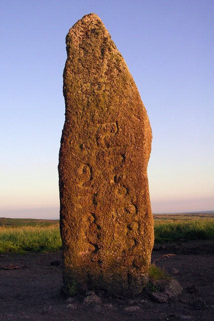
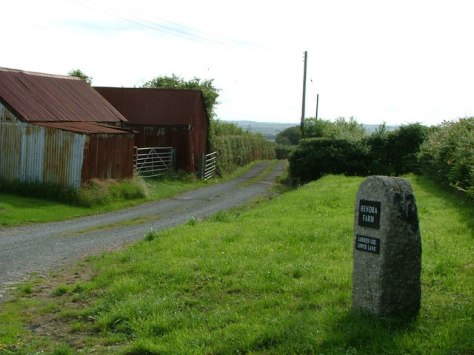
Not far from Men Scryfa is the Four Parish Stone.  This stone indicates the point in which the boundaries of the four ancient parishes of Zennor, Gulval, Madron and Morvah meet.  This is not the modern civil parish boundaries but the much older church boundaries.  A document from the 17th century mentions this place in the landscape, referring to it as ‘Meane Crouse’ or ‘stone cross’ suggesting the presence of a stone cross which marked this important crossroads.  Any traveller to Cornwall will note how stone crosses covered in moss and worn by weather are often found at road junctions.

From here the landscape is dominated by the impressive tor known as Carn Galva and whilst not the highest point in West Penwith (Watch Croft the adjacent tor takes that accolade) it is the most atmospheric of tors with its giant granite boulders standing silent sentinel over the millennia.  It is now generally believed that Carn Galva is one of the few Neolithic enclosures to be found in Cornwall – Carn Brea, Helman Tor and Trencrom are the more well known.

bodrifty_ancient_settlement_-_geograph-org-uk_-_1041
One of the many remains of roundhouses to be found at Bodrifty – behind can be seen the high ground leading to Zennor Hill and Carn Glava. Photo by Alan Simkins (geograph.co.uk)

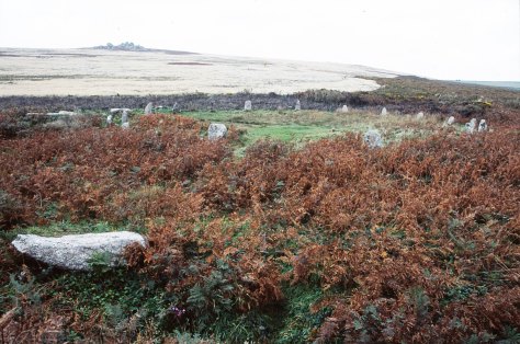
Further on the walker can take a minor side trip to see the Nine Maidens stone circle and the remains of a roundhouse settlement probably dating to the late Bronze Age/early Iron Age (Bodrifty).  Nearby the farmer at Bodrifty Farm has recreated a roundhouse and it is possible to visit but do ask first.  After Bodrifty the trackway goes past Mulfra Quoit.

mulfraquoitborlase
Mulfra Quoit – drawing by William Borlase 1769.

Alternatively and the most likely direction for the trackway to follow is across the moorland of Bosporthennis Common between the highpoint of The Beacon and Mulfra Hill to the parish boundary stone known as the Bishops Head and Foot.

“Used over generations, these trackways created permanent scars across hills and valleys, and formed a web of easily followed routes which were later utilised to mark the extent of private estates which had superseded previous communal use of tribal lands.  When the system of parishes was established about the 12th century additional use was made of these muddy tracks to form their boundaries in conjunction with streams and prominent rocks” (Antiquities of West Cornwall – The Tinners Way.  Ian Cooke 1991)

It is often speculated that the old parish boundaries are based on ancient trackways and at the Bishops Head and Foot there are important paths which traverse Penwith from Zennor to Castle-an- Dinas and Chysauster (both important Iron Age sites) and on to Mounts Bay.  The Tinners Way as already demonstrated follows several sections of parish boundaries along the high ground.  The trackway then continues through the parish of Towednack along the base of Rosewall Hill covered in old mining shafts and then onto the village of St Ives and The Island.

OLYMPUS DIGITAL CAMERA
The view from the Lady Downs in Towednack looking east.  In the distance it is possible to see Perran Sands and St Agnes Beacon.  Photo by Sheila Russell (geograph.co.uk)

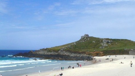
Although today there stands a small chapel to St Nicholas on the Island it is thought that originally the headland was a much older promontory fort.  Its position which overlooks Porthmeor Beach and the wider expanse of St Ives bay including the entry to Hayle Harbour and with views all the way up the coast would suggest it was an important site.

OLYMPUS DIGITAL CAMERA
The Island at St Ives – Porthmeor Beach is in the foreground.  Photo by Chris Dixon (geograph.co.uk)

The Hayle Estuary was an important trading port on this coast until the Medieval period.  Dredging in the now silted harbour has in the past brought up finds from all periods including the Roman period and earlier.  Overlooking the harbour is the ancient enclosure of Trencrom Hill which as mentioned before can be dated to the Neolithic and later.

“It used to be thought that the earliest routes in Britain were prehistoric ‘ridgeways’, long distance trackways…This idea grew up in the early years of archaeological studies when the most obvious prehistoric monuments, such as Bronze Age burial mounds and Iron Age hillforts, were found concentrated in upland areas.” (Pre-industrial Roads, Trackways and Canals Historic England 2011).

Even though there is no concrete way of dating this particular route there are certainly a lot of indicators which point to it being an important part of the landscape in West Penwith with a long and fascinating history.

A useful wee book to read if you can get hold of one is “The Tinners Way”by Ian Cooke.  It is in essence a guidebook for walkers wishing to do the the Tinners Way, detailing the route and the  various features along the way.


Clues in the Landscape – Placenames, Maps and Fields.

“When you hear the Cornish folk mentioning the names of their villages, hills, and other landmarks, you will notice something un-English about them.  In the accent and cadence of some of the placenames there is an echo of the goblin world.  Is there not, in such names as Ogbeare, Killeganogue and Poulza, an oddity – a twist that is just on the edge of the bizarre.”

(Hopkins T. ‘Our Beautiful Homeland: Cornwall’ date unknown)

It is true that the first thing a visitor to Cornwall will notice is the placenames, they are very ‘un-English’ in particular the further west you go.  My interest in them began many years ago as a student writing a masters dissertation on the landscape continuity on the north coast of West Penwith.

The study of placenames can be highly complex, after all names do change for whatever reasons and in the case of Cornwall the names are often in Cornish which as a language has also undergone many changes.  The Cornish language is related to both the Welsh and Breton languages, all of which are regarded as being descended from the language spoken by the ‘Celts’.  The relationship with these Brittonic languages is often used as evidence for the age of a particular placename, albeit in a general sense.

“The name of a village or farm or field may describe the locality as it was when the name was given, or refer to a natural or man-made feature nearby, or include the name of a pioneer farmer or priest (the latter often termed a ‘saint’).  Names can seldom be translated with the certainty aimed a in normal translation between languages; generally they can only be interpreted, with a greater or less degree of probability, as unconscious and unintended messages from the past which are seldom free from ambiguity or obscurity.  The prime rule in placename interpretation is to attempt none until all available forms of the name have been considered, and then to place greater reliance on earlier rather than later forms.” (Pool P. A. S. 1990 ‘The Fieldnames of West Penwith).

The distribution of Cornish placenames is not uniform across the county, those places nearest the Tamar River – the natural boundary between  Cornwall and Devon – have a greater tendency to be more English than those in the far west.  In my dissertation I surveyed an area of the north coast of west Penwith (within the parishes of Morvah and Zennor) and of the forty placenames to be found on the Tithe map of 1841 only one had an English name – the hamlet of Wicca.

Below are a handful of the most common prefixes used in Cornish placenames and their meaning (from Weatherhill C. 1998 ‘Cornish Placenames and Language’)

Bos – as in Boscastle, Boscawen or Bosavern.  Also found as Bot-, Bo-, Boj-, Bus-, and Bod-.  Meaning dwelling or home it seems to be a very early form whose usage dwindles by 1500.  It is often followed by a persons name such as Bodilly on the Lizard which can be translated as ‘the dwelling of Deli’.

Car-/Gear-/Caer-/Cr- as in Caervallack, Carwythenack or Carvossa.  Meaning an enclosed settlement and occasionally a ‘fort’.  Often found associated with late prehistoric farmsteads within round enclosures as well as Iron Age hillforts.  Carvedras near Truro can be translated as ‘Modret’s fort’.

Carn – as is in Carn Brea, Carn Meal or Carn Clew.  One of the most common still in use today and is used in reference to prominent rock formations, on hilltops it can translated to ‘tor’ whilst at other locations it might mean ‘crag’ or ‘rockpile’.  Occasionally it may even refer to a Bronze Age Barrow.


carn_brea_hill_from_the_east_-_geograph-org-uk_-_353749
Carn Brea – the rocky tor visible on the hill top. (geograph.co.uk – 1185968)


Chy-/Che-/Ch-/Ty- as in Chun, Chyanvounder or Chynoweth.  Meaning either ‘cottage’ or ‘house’.   Thus Chyandour can be translated as ‘house by the water/stream’.  This prefix replaces the earlier ‘Bos’.

Hen – as in Hendra or Henscath. Meaning old as in former, ancient.  Hendra can in its simple form mean ‘old farm’ but is better interpreted as ‘farm which still stands on its original site.


hendra_farm_-_geograph-org-uk_-_210812
Entrance to Hendra Farm (geograph.co.uk – 210812)


Lan – as in Lamorran or Lanzeague.  Meaning ‘church enclosure’ it became redundant by 1500, historians usually take the presence of this prefix as an indicator for an early church site often surrounded by an enclosure which in some cases is a reused prehistoric site.

Tre-/Trev-/Tr- as in Tregenna or Tregeseal to name but two – this is by far and away the most common of all prefixes.  Meaning “farming settlement’ and later used to denote a larger settlement such as village.  They are often followed by a persons name such as Tregiffian or ‘Gifyan’s farm’ and in other cases it might be followed by a descriptive word such as Trencrom or ‘the farm on the curve’.

Venton-/Fenton- as in Venton Vedna or Ventonraze.  Meaning ‘a well’ in the sense of a natural spring, an artificially dug well is ‘Peeth’.  Often the prefix is followed by a name of a saint such as Venton Uny or ‘the well of St Euny’ others might be followed by a distinguishing feature such as Ventonwyn or ‘the white well’.

Of course understanding the meaning behind the names is not the only source of information.  Looking at the distribution of certain placenames within a given area may hint at the evolution of the human landscape.  In some areas it is possible to see the stratigraphy of the landscape.  An essential part of such a study involves the use of maps.


john_speed_-_map_of_cornwall_-_1614_-_001
John Speed’s Map of Cornwall 1614


No study of the landscape can be conducted without a good range of maps.  Early Ordnance Survey maps and Tithe maps are crucial in understanding any landscape before modern incursions such as motorways, housing subdivisions, caravan parks and business parks, make an appearance.  Even in the case of West Penwith the choice of the 1841 Tithe Map during my dissertation was to ensure that any more recent names attached to barn conversions and holiday lets did not lead to false results.  Maps can also show features which may no longer be obvious on the ground such as hedges which may have later been removed and mining remains among others.


1280px-ordnance_survey_drawings_-_lands_end_osd_1
An early drawing for large scale OS map of Lands End.  Two points of interest are – the tin and copper mines are indicated by a dotted lines, also the circular marking on the left indicate the area around Sancreed and the hillfort of Caer Bran.  It was not until 1816 that the recording of archaeologica sites on OS maps became obligatory.


Of course very early maps can be quite frustrating as often the information included is not clear and/or very selective according to who made the map and why.   Just because a settlement does not appear on one map does not mean it did not exist at the time of surveying.  For example, the Domesday Book records only a handful of settlements in the whole of West Penwith.  It seems highly unlikely that the region was all but empty, but given this was an economic text and not a history one it is not too surprising either.  To this extent gaining insight from a wide range of maps is often the best course of action.

Another source of information which can often be overlooked in the study of past landscapes are fieldnames.  Although they are less well documented and it is not until the Tithe Apportionment of 1841 that fieldnames are properly recorded,  albeit by this stage most are in English. It is also important to note that by their very nature fieldnames are transient, their names can change as their usage does.  However there is on occasion names which stick and just occasionally these names can hint at a previously unknown archaeological site or field usage.  For example Park an Vellan could suggest the presence of a mill (vellan being a form of melyn or mill) and Park Menheere suggests the presence of standing stone.

In the case of later English fieldnames some may well have been directly translated from the Cornish and are thus older than expected.  So Spring Field may have originally been Park an Venton or Barrow Field was Gweal Creeg.


800px-fields_near_zennor
A view of fields near the hamlet of Zennor demonstrating the higgly-piggly nature of the fields systems.  (geograph.co.uk – 633)


The study of placenames, maps and fieldnames is one of the least intrusive forms of research a person can do and yet can yield a myriad of information that in some cases was not known.  When combined with other sources such as documents and aerial photography it becomes a powerful part of archaeological research providing fresh insight into our ancient landscapes.


775px-west-penwith-coast-2-edited
An aerial photo giving a birds eye view over a portion of the West Penwith coastline (copyright Tom Corser 2009)


Once you have got your eye in so to speak, it will be forever impossible to go for a simple walk in the landscape.  I am doomed to be wandering the landscape always looking for patterns, asking what does that name mean and is it in it’s original form.

Sources:

Gelling M. (2000) Place-Names in the Landscape Phoenix Press

Hopkins R. T. (?) Our Beautiful Homeland: Cornwall Blackie and Son Ltd

Pool P. A. S (1990) The Fieldnames of West Penwith Published by the Author

Weatherhill C. (1998) Cornish Place Names and Language Sigma Leisure


A Day Trip to Kawau Island

Blue sea, blue sky, warm sunshine and a gentle breeze.  It was a perfect day for a trip to the beautiful island of Kawau in the Hauraki Gulf .

Kawau Island is roughly 8 kilometers long and 5 kilometers wide, its highest point is Mt Grey at 182metres above sea level.  Kawau is the Maori word for cormorant and although these birds may appear plentiful today it is undoubted that in times past they would have been far greater in number.  For those wishing to experience island life access is by the service known as the Mail Run. The ferry to the island leaves from the seaside hamlet of Sandspit, just north of Warkworth and about an hour from Auckland. Full of day trippers slathered in sunscreen it visits the various wharves dotted along the sheltered side of the island delivering the mail, groceries and other goods.  For the visitor it is a good introduction to an island which has only two short private roads and where the majority of properties rely on access to the sea.  Neighbours visit neighbour either on foot or by boat and kayak.

img_4739

School House Bay – there is no longer a school on the island. The few school age children go to school on the mainland.

Island History

Prior to the Europeans Kawau was often fought over by local Maori.  During the 18th century a ‘pirate’ like group of Maori lived on the island – there are at least three known pa sites (two on Bon Accord Harbour and one in the north of the island).  According to tradition the Kawau Maori would attack other Maori travelling around the island, something which was not tolerated for long.  Eventually, other local iwi (tribes) from the mainland banded together and attacked the Maori of Kawau.  Those on the island were completely massacred and tradition says a large feast ensued at Bostaquet Bay.  A tapu was placed on Kawau making it no-go area for Maori – the tapu is still in place.

The next important phase of the history of the island began in 1842 with the discovery of copper and manganese.  Miners were brought in from Wales and Cornwall to work the mines and smelting works.  The population of the island at this time was approximately 300.

The remains of the smelting works can be seen in Bon Accord Harbour just along from the present day yacht club.  On a small point between Dispute Cove and South Cove there is also the ruins of pumphouse constructed to alleviate flooding issues.  The pumphouse would not look out of place in Cornwall.  In 1844/45 the mine produced some 7000 pounds of Copper which represented a third of Auckland’s exports for that year.  Unfortunately issues with flooding, shipping and infighting resulted in the mines being closed down in 1855.

received_512183903808061received_2165629283613444

In 1862 Sir George Grey, then the Governor of New Zealand paid 3,700 pounds for Kawau Island and turned it into a private retreat.  He turned the former mine managers house into the imposing mansion you see today and imported many exotic plants and wildlife to the island.  In 1888 Sir Grey sold Kawau and Mansion house had several owners and in 1910 it became a guest house and a popular retreat for Aucklanders.  The last private owner sold the house in 1967 to the Government for inclusion in the Hauraki Gulf Maritime Park.

img_4750
Mansion House, Mansion House Bay – the ferry drops people off here to swim, picnic and walk island paths.

However it was not until the late 1970s was a plan put together to preserve the historical character of the island and thus the house.  Today 10% of the island is in public ownership as the Kawau Island Historic Reserve (and includes Mansion House and Bay) which is administered by the NZ Department of Conservation.   One of the many ongoing issues faced by the island is the damage done to the native flora and fauna by Sir Grey’s introduced species, namely the wallabies and possums.  Both animals have been responsible for the destruction of much of the native bush.  However, slowly but surely the tide is turning and now there are kiwi, bellbirds, tui, kereru and more returning to the island.  Kawau Island is in fact home to two thirds of the entire population of the North Island weka.

img_4753
One of the many weka who frequent the picnic benches…


Kawau Island 2022

It was another sunny day and the ferry ride out to Kawau was as always a lovely way to spend the day. Unlike the previous visit, several years earlier, Mansion House was open to visitors. An opportunity not to be missed. 

The following photos are of the interior of the house, in the main room there is a display of ethnographic and Maori items loaned to the Mansion House from the Auckland Museum. 


Life has been a little strange in the last two years but spending time on the sea and on Kawau was the much needed balm to soothe those frayed edges. Its peace and tranquility (even with peacocks) allowed the mind and soul to reset itself and I for one came home feeling refreshed and ready for whatever else might come my way.

It is a highly recommended day trip…